Endeavour Drive - Drivability analysis |

  |
Endeavour Drive - Drivability analysis |
 Sep 23 2008, 12:46 PM Sep 23 2008, 12:46 PM
Post
#181
|
|
|
Senior Member  Group: Members Posts: 2920 Joined: 14-February 06 From: Very close to the Pyrénées Mountains (France) Member No.: 682 |
Plus we could quite already be there by next Mars winter.
-------------------- |
 |
 
|
|
Sep 23 2008, 01:30 PM
Post
#182
|
|
 Junior Member Group: Members Posts: 57 Joined: 17-May 06 From: Houston, Texas Member No.: 776 |
This is great news. The trip to Victoria was the most exciting space journey I ever witnessed. This one will be just as exciting.
-------------------- |
|
|
|
|
Sep 23 2008, 01:46 PM
Post
#183
|
|
 Member Group: Members Posts: 593 Joined: 20-April 05 Member No.: 279 |
With apologies to Mr Shakespeare and, of course, our very own poet laureate:
A Sonnet for Opportunity Alight on Mars and now work your thoughts: feast The mind's eye on the edge of Victoria. See our heroine now looking southeast Eyes focussed on this brave new endeavour. As thin air tugs sand-blasted mast, behold! Wheels turn, powered by Phoebus' distant light And with steady grip, this valiant soul, Now roves to take on the furrow'd sight That stretches before: the constant billows Of the endless, immutable, sand-sea Whose lofty, rusted surge in past days Became a near-fatal purgatory. So wish her luck with this dangerous quest And should failure await, think on her best. Andy |
|
|
|
|
Sep 23 2008, 02:03 PM
Post
#184
|
|
|
Member Group: Members Posts: 877 Joined: 7-March 05 From: Switzerland Member No.: 186 |
I wonder in which way the HIRISE folk could help by processing these huge images for better visualization and understanding of possible paths. Run they any special software to create enhanced reliefs from the images?
-------------------- |
|
|
|
|
Sep 23 2008, 02:06 PM
Post
#185
|
|
|
Founder Group: Chairman Posts: 14432 Joined: 8-February 04 Member No.: 1 |
Well - shape from shading with ISIS would work to a degree, but to be honest, human judgement is probably best.
Doug |
|
|
|
|
Sep 23 2008, 02:18 PM
Post
#186
|
|
|
Member Group: Admin Posts: 976 Joined: 29-September 06 From: Pasadena, CA - USA Member No.: 1200 |
QUOTE (djellison @ Sep 23 2008, 06:06 AM)  Well - shape from shading with ISIS would work to a degree, but to be honest, human judgement is probably best. Doug I am pretty sure shape from shading would work, but when I worked on Victoria a student who worked in my group did terrain classification from texture and color and the results were quite impressive. Unfortunately she is now working for Google. Maybe I'm going to ping her and see if I can get ahold of her code. I agree with you that human processing is probably more flexible. I definitely was not planning to just use the map and let Opportunity blindly drive through. MANY eyes will look over HiRISE, PANCAMs and NAVCAMs. Paolo -------------------- Disclaimer: all opinions, ideas and information included here are my own,and should not be intended to represent opinion or policy of my employer.
|
|
|
|
|
Sep 23 2008, 02:23 PM
Post
#187
|
|
|
Forum Contributor Group: Members Posts: 1372 Joined: 8-February 04 From: North East Florida, USA. Member No.: 11 |
I am encouraged to hear Oppy won't be commanded to drive blindly !!!!!
 |
|
|
|
|
Sep 23 2008, 02:59 PM
Post
#188
|
|
 Senior Member Group: Members Posts: 2173 Joined: 28-December 04 From: Florida, USA Member No.: 132 |
QUOTE (TheChemist @ Sep 23 2008, 04:45 AM) Please, don't waste any time looking at the "path" I posted earlier... I thought the tone and copious use of smilies made the (lack of) seriousness of the post clear. Too late. Your route has already been coded, uploaded, and locked into Opportunity's navigation program. Off we go and good luck! 
|
|
|
|
| Guest_Oersted_* |
Sep 23 2008, 03:49 PM
Post
#189
|
|
Guests |
Ok, it is great fun to make route maps, but obviously not what Paolo needs, as he said so well.
What´s needed is an overview map, with ripple type areas clearly delineated. I still didn´t see a better suggestion, IMHO, than the one I posted earlier in the thread and which I copy here below. Sorry for the impertinence, but I think we should focus on what Paolo is asking for and not go out in a lot of fascinating but not really relevant tangents, with poetry, specific route maps, etc. This is the first time we´re getting a request from the rover team for actual help. We got it because the cumulative talents at UMSF are very impressive. But let´s focus those talents on the job at hand! QUOTE (Oersted @ Sep 22 2008, 05:49 PM) Great idea Cody, that's what I want to see too! Colouring for area ripple orientation and area ripple height (inferred by spacing) is a good idea, but I have a different suggestion: We could have a "geological" map with differently striped areas, where the striped areas are enlarged images of the prevalent ripple structure in a given area. Either artificially drawn stripes or photographic enlargements of a typical ripple structure in the given area. We'd then have a clear overview map with striped areas, where stripe width and orientation indicate the structure of the given area. I think that would be a nice tool for large-scale planning of this mega-drive, because the underlying ripple/surface structure would be immediately obvious to the eye, with no extra effort required to "translate" colouring to a particular terrain type. Good map-making is about immediately and instinctively being able to infer information. A map that could be printed out in 1x2 meters would be a great "overview" tool to hang on the wall in the rover driver's room. |
|
|
|
| Guest_Oersted_* |
Sep 23 2008, 03:55 PM
Post
#190
|
|
Guests |
I´ve highlighted our MISSION STATEMENT, as set out by Paolo, in bold:
QUOTE (RoverDriver @ Sep 23 2008, 02:23 AM) Seriously, at the moment I'm trying to find a way to classify the HiRISE image that includes VC and surrounding areas so that we can identify areas that look similar to what we have driven on. Paolo No route but a visual classification of surface and ripple type areas. |
|
|
|
|
Sep 23 2008, 04:13 PM
Post
#191
|
|
|
Member Group: Members Posts: 507 Joined: 10-September 08 Member No.: 4338 |
It might help to have a collection of example HIRISE images of the terrain that has already been driven over, with an indication of how easy or difficult it was to traverse. The indication could either be subjective (coming from the rover driver), or a measure of the number of meters covered in that drive. This could be used as a guide in analyzing the new terrain.
|
|
|
|
|
Sep 23 2008, 04:15 PM
Post
#192
|
|
|
Founder Group: Chairman Posts: 14432 Joined: 8-February 04 Member No.: 1 |
QUOTE (marsophile @ Sep 23 2008, 05:13 PM) It might help to have a collection of example HIRISE images of the terrain that has already been driven over, Phil already did that. |
|
|
|
|
Sep 23 2008, 04:20 PM
Post
#193
|
|
|
Senior Member Group: Members Posts: 2173 Joined: 28-December 04 From: Florida, USA Member No.: 132 |
QUOTE (djellison @ Sep 23 2008, 12:15 PM) Phil already did that. http://www.unmannedspaceflight.com/index.p...st&p=126432 |
|
|
|
|
Sep 23 2008, 05:57 PM
Post
#194
|
||
|
Solar System Cartographer Group: Members Posts: 10153 Joined: 5-April 05 From: Canada Member No.: 227 |
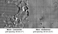
Someone asked about a comparison of LeMonnier and Endeavour - 'which was the largest crater explored by a rover?'
Here's a side by side comparison from Map-A-Planet - you can have endless fun playing with that website. The scale is almost the same. The grids are 1 degree for the Moon and 0.5 degree for Mars, both about 30 km per grid space, to provide scale. LeMonnier is twice the diameter of Endeavour, at least, and much more dramatic. Phil
-------------------- ... because the Solar System ain't gonna map itself.
Also to be found posting similar content on https://mastodon.social/@PhilStooke Maps for download (free PD: https://upload.wikimedia.org/wikipedia/comm...Cartography.pdf NOTE: everything created by me which I post on UMSF is considered to be in the public domain (NOT CC, public domain) |
|
|
|
|
|
|
Sep 23 2008, 06:00 PM
Post
#195
|
|
|
Member Group: Members Posts: 235 Joined: 2-August 05 Member No.: 451 |
QUOTE (Phil Stooke @ Sep 23 2008, 11:57 AM) Someone asked about a comparison of LeMonnier and Endeavour - 'which was the largest crater explored by a rover?' How's LeMonnier compare to Gustav? |
|
|
|
|

|
Lo-Fi Version | Time is now: 28th April 2024 - 03:07 AM |
|
RULES AND GUIDELINES Please read the Forum Rules and Guidelines before posting. IMAGE COPYRIGHT |
OPINIONS AND MODERATION Opinions expressed on UnmannedSpaceflight.com are those of the individual posters and do not necessarily reflect the opinions of UnmannedSpaceflight.com or The Planetary Society. The all-volunteer UnmannedSpaceflight.com moderation team is wholly independent of The Planetary Society. The Planetary Society has no influence over decisions made by the UnmannedSpaceflight.com moderators. |
SUPPORT THE FORUM Unmannedspaceflight.com is funded by the Planetary Society. Please consider supporting our work and many other projects by donating to the Society or becoming a member. |
|