

Endeavour Drive - Drivability analysis |

  |
Endeavour Drive - Drivability analysis |
 Sep 23 2008, 06:09 PM Sep 23 2008, 06:09 PM
Post
#196
|
|
|
Solar System Cartographer  Group: Members Posts: 10153 Joined: 5-April 05 From: Canada Member No.: 227 |
Gusev! I'll let someone else do this.
Phil -------------------- ... because the Solar System ain't gonna map itself.
Also to be found posting similar content on https://mastodon.social/@PhilStooke Maps for download (free PD: https://upload.wikimedia.org/wikipedia/comm...Cartography.pdf NOTE: everything created by me which I post on UMSF is considered to be in the public domain (NOT CC, public domain) |
 |
 
|
|
Sep 23 2008, 06:09 PM
Post
#197
|
|
|
Senior Member Group: Moderator Posts: 4279 Joined: 19-April 05 From: .br at .es Member No.: 253 |
Hurricane Gustav?
 (sorry, I couldn't resist) |
|
|
|
|
Sep 23 2008, 06:10 PM
Post
#198
|
|
|
Senior Member Group: Moderator Posts: 4279 Joined: 19-April 05 From: .br at .es Member No.: 253 |
Now seriously and back to the main topic:
Sorry to be pedantic but I still believe this task must be automated in some way. I think its already clear that whats needed is a map that characterizes the terrain in terms already known like tarmac, purgatory, bedrock, small ripples. This map should also be of a lower resolution than the HiRISE pictures; or in other words, it should reduce an e.g. 100x100 pixels area to a single characterized point, otherwise it looses its purpose which is to allow mid and long-range route planning. One way to do this task is to slice the big picture in 100x100pix. pieces and to manually compare them with a set of pre-selected types of terrain. Needless to say that such a task would be time consuming and in case it was shared among a number of volunteers the results wouldnt be homogeneous. What would be classified as purgatory like by one might be characterized as small ripples by another one. Another way to do this task could be again to slice the big picture in 100x100pix. pieces and to automatically characterize them. It was already proposed to use the wavelength of the dunes as an indicator so the mean wavelength of each 100x100 piece could be compared with the mean wavelengths of the reference pieces (tarmac, purgatory, etc.). The mean wavelength could be calculated, probably using FFT, and I think some of the HiRISE images (e.g. the one I use in the route map) have enough dynamic range and S/N ratio to be used for this purpose, but we need someone with experience on this area (I havent). I think its worth a try. |
|
|
|
|
Sep 23 2008, 06:27 PM
Post
#199
|
|
 Senior Member Group: Moderator Posts: 2262 Joined: 9-February 04 From: Melbourne - Oz Member No.: 16 |
Well just to update you on my progress (less than I hoped as I have a lot on at the moment). I'm now able to load chunks of the JP2 into a C++ program and am going to attempt to get it to recognize different ripple sizes, probably with some sort of Fourier analysis.
No promises though, it maybe too hard given for very limited amount of time I have to work on this. -------------------- |
|
|
|
|
Sep 23 2008, 06:28 PM
Post
#200
|
|
|
Newbie Group: Members Posts: 14 Joined: 23-October 06 Member No.: 1277 |
The Mars Express images by ESA are sometimes great in detail..
and I have seen some images made as in "fly over" Did Mars Express photograph and "3d" the Opportunity area it is currently located.. Or can it do so soon ? |
|
|
|
|
Sep 23 2008, 07:07 PM
Post
#201
|
|
|
Senior Member Group: Members Posts: 1074 Joined: 21-September 07 From: Québec, Canada Member No.: 3908 |
The HRSC on Mars Express has a resolution of only 10m (2m on selected targets), not enough for our current purpose.
|
|
|
|
|
Sep 23 2008, 07:15 PM
Post
#202
|
|
 Senior Member Group: Moderator Posts: 2785 Joined: 10-November 06 From: Pasadena, CA Member No.: 1345 |
QUOTE (Tesheiner @ Sep 23 2008, 02:10 PM)  One way to do this task is to slice the big picture in 100x100pix. pieces and to manually compare them with a set of pre-selected types of terrain. Needless to say that such a task would be time consuming and in case it was shared among a number of volunteers the results wouldnt be homogeneous. What would be classified as purgatory like by one might be characterized as small ripples by another one. Could we take a "Galaxy Zoo" approach and divvy up each chunk of terrain among multiple volunteers? (Judging from the posts on this thread, I'll bet there's a heckuva lot of volunteers rarin' to go). Using Phil's template as a guide, each volunteer makes his ratings, then sends back the data. Multiple volunteers per terrain unit could allow a statistical average to be developed for each terrain piece. (And like the "Galazy Zoo" approach, a training set could be used for training, and for validating that the volunteers are ready.) -Mike -------------------- Some higher resolution images available at my photostream: http://www.flickr.com/photos/31678681@N07/
|
|
|
|
|
Sep 23 2008, 07:19 PM
Post
#203
|
|
 Senior Member Group: Members Posts: 3419 Joined: 9-February 04 From: Minneapolis, MN, USA Member No.: 15 |
QUOTE (efron_01 @ Sep 23 2008, 01:28 PM) The Mars Express images by ESA are sometimes great in detail.. and I have seen some images made as in "fly over" Did Mars Express photograph and "3d" the Opportunity area it is currently located.. Or can it do so soon ? Not in the kind of resolution needed to actually see and characterize the ripples. For that, you need the HiRISE camera. (At least, if the MEX cameras, even the HRSC, can image something as small as the ripples in enough detail to do a stereo image that gives you the size and extent of individual ripples, I'm certainly not aware of it...) -the other Doug -------------------- The trouble ain't that there is too many fools, but that the lightning ain't distributed right. -Mark Twain
|
|
|
|
|
Sep 23 2008, 07:43 PM
Post
#204
|
|
|
Senior Member Group: Members Posts: 1582 Joined: 14-October 05 From: Vermont Member No.: 530 |
QUOTE (Juramike @ Sep 23 2008, 03:15 PM) Could we take a "Galaxy Zoo" approach and divvy up each chunk of terrain among multiple volunteers? Those who suggested that clickworkers was the closest analogy were correct. Basically you just need an "impassible dune" cursor for image markup. Galaxyzoo and stardust@home are similar, but galaxyzoo doesn't use clickable images and stardust@home allows a single click on a movie. |
|
|
|
|
Sep 23 2008, 08:17 PM
Post
#205
|
||
 Senior Member Group: Members Posts: 1229 Joined: 24-December 05 From: The blue one in between the yellow and red ones. Member No.: 618 |
QUOTE (Stu @ Sep 22 2008, 07:46 PM) I can't decide if that's very funny, or very hurtful...  I certainly hope that you, like Rui, decide it's funny, Stu. It was definitely intended to be. Seriously though, you two are far and away the most poetically inspired and poetically eloquent members at UMSF, and I would love to see the outcome of a period of collaboration between you, in giving expression to the spirit that pervades this forum. The desert island is only one idea for a venue, and comes to me because I can see out my window a perfect example in Mokoli'i

-------------------- My Grandpa goes to Mars every day and all I get are these lousy T-shirts!
|
|
|
|
|
|
|
Sep 23 2008, 08:24 PM
Post
#206
|
||
|
Member Group: Members Posts: 877 Joined: 7-March 05 From: Switzerland Member No.: 186 |
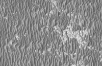
Unsharp masking could be useful for the chunks:
GIF format
Attached thumbnail(s)
-------------------- |
|
|
|
|
|
|
Sep 23 2008, 08:26 PM
Post
#207
|
|
 The Poet Dude Group: Moderator Posts: 5551 Joined: 15-March 04 From: Kendal, Cumbria, UK Member No.: 60 |
Don't worry, just kidding, I thought it was really funny.
 Not as funny as Rui's follow-up sketch... that had me chuckling all day during a rather challenging and not-exactly-laugh-a-minute Course about constipation and caring for terminally ill patients (and you lot all thought my life was full of poetry and martian daydreaming, eh?)... god, we'd be like a space geek version of "Withnail and I"...!!! 
-------------------- |
|
|
|
|
Sep 23 2008, 08:32 PM
Post
#208
|
|
 Member Group: Members Posts: 646 Joined: 23-December 05 From: Forest of Dean Member No.: 617 |
Bundling up comments on several posts plus my own ramblings; apologies for the length.
It seems support is emerging for two approaches: 1. software automation
2. A Mechanical Turk, human-driven distributed process. (several variants on this have been suggested.)
I suggest that we do both. There's no reason we couldn't start on a Mechanical Turk process whilst the bit-twiddlers do their thing; at some point (a week, two, ten,..) the software's results become more useful than the manual ones, and the baton is passed. A purely manual process could start whilst work is underway on a web-based, semi-automated, galaxy-zoo type solution, AND a dedicated program to do the whole thing. I hate it when people say this in email at work, but as I've already used the word "solution"...  ... "thoughts?" ... "thoughts?"QUOTE (Geert @ Sep 23 2008, 04:49 AM) Note for ships we normally find that the height of the waves is of less importance then their wavelength (compared to the ships length), I guess it is more or less similar for oppy: a low but steep ripple will give you far more trouble then a high but 'long' ripple. Correct me if I'm wrong, but my impression is that all the dunes encountered on the way to Victoria had the same angle of repose, so the visible width has a linear relationship to cross-a-bility. QUOTE (ustrax @ Sep 23 2008, 08:10 AM) Stu - Rui! Isn't that a boat?! They've come to rescue us! Me - Rescue...boat...us...(processing information...)... My friend...Who are we, Mankind, but the rescue, the boat, the sea, the Onward?... And then we would battle ourserlves to death with coconuts... $wine{'cava'}->spray("nose"); QUOTE (RoverDriver @ Sep 23 2008, 08:38 AM) So for the time being my problem still is "find the quickest and safest path to Endeavour". Question: which part of Endeavour? I've been assuming your aim point is the jagged western rim peaks; is that right? Is there a definite aim point, or a defined area to aim at? -------------------- --
Viva software libre! |
|
|
|
|
Sep 23 2008, 08:36 PM
Post
#209
|
|
|
Junior Member Group: Members Posts: 27 Joined: 22-September 08 Member No.: 4349 |
QUOTE (Shaka @ Sep 22 2008, 04:04 PM) Holy mackrel dere, Beauford! You're way ahead of us all! Can you show us this track drawn on a maximum HiRISE resolution image of the area? At least the first few km from Victoria. Here's my rudimentary attempt at showing a proposed track. For more detail at the "points" of interest, zoom in on the HiRISE image at: http://marsoweb.nas.nasa.gov/HiRISE/hirise...SP_001414_1780/ At this point I don't seem much merit to tracking beyond the giraffa camelopardalis, except in very general terms. ...lots of options.
Attached File(s)
|
|
|
|
|
Sep 23 2008, 08:52 PM
Post
#210
|
|
|
Senior Member Group: Members Posts: 1229 Joined: 24-December 05 From: The blue one in between the yellow and red ones. Member No.: 618 |
QUOTE (RoverDriver @ Sep 23 2008, 04:18 AM) I am pretty sure shape from shading would work... MANY eyes will look over HiRISE, PANCAMs and NAVCAMs. Paolo Thank you, Paolo, for clearly stating your wishes, and thank you Oersted, Imipak, Tesh, Phil and the others who have made clear, practical contributions to fulfilling those wishes. An area map of favorable and unfavorable terrain for Oppy (especially if it can be generated by automated software) will be a major contribution to planning the course of rovers in this and other missions. I have no expertise in this higher order image processing, but I would hope that a way could be found to include points of scientific interest - e.g. craters and cobble clumps - as map features so that a planned track can incorporate them, if the PIs judge them to be worth closeup examination. It is probably too complex a task to automate selecting points of interest, but I would be willing to manually circle any such features I could resolve in a HiRISE mosaic. Points that are isolated by impassable ripple zones could be easily bypassed in preference to those lying in 'safe' zones. -------------------- My Grandpa goes to Mars every day and all I get are these lousy T-shirts!
|
|
|
|
|

|
Lo-Fi Version | Time is now: 27th April 2024 - 08:16 PM |
|
RULES AND GUIDELINES Please read the Forum Rules and Guidelines before posting. IMAGE COPYRIGHT |
OPINIONS AND MODERATION Opinions expressed on UnmannedSpaceflight.com are those of the individual posters and do not necessarily reflect the opinions of UnmannedSpaceflight.com or The Planetary Society. The all-volunteer UnmannedSpaceflight.com moderation team is wholly independent of The Planetary Society. The Planetary Society has no influence over decisions made by the UnmannedSpaceflight.com moderators. |
SUPPORT THE FORUM Unmannedspaceflight.com is funded by the Planetary Society. Please consider supporting our work and many other projects by donating to the Society or becoming a member. |
|


 )
)