Endeavour Drive - Drivability analysis |

  |
Endeavour Drive - Drivability analysis |
 Sep 24 2008, 01:10 PM Sep 24 2008, 01:10 PM
Post
#241
|
|
|
Founder  Group: Chairman Posts: 14432 Joined: 8-February 04 Member No.: 1 |
"at anytime we could need a path change"
Which is why we need to try and get some sort of survey done before we leave the Victoria Annulus 
|
 |
 
|
|
Sep 24 2008, 01:31 PM
Post
#242
|
|
 Junior Member Group: Members Posts: 57 Joined: 17-May 06 From: Houston, Texas Member No.: 776 |
I wonder if we'll get to see the Explorer crater on the south side of Victoria? It would be interesting to see the zone between the two craters.
-------------------- |
|
|
|
|
Sep 24 2008, 01:43 PM
Post
#243
|
|
|
Junior Member Group: Members Posts: 57 Joined: 17-May 06 From: Houston, Texas Member No.: 776 |
Is it just me, or do the camera lenses look a little cleaner now that we are out of Victoria (perhaps a wind gust help clean them)?
-------------------- |
|
|
|
|
Sep 24 2008, 02:29 PM
Post
#244
|
|
|
Senior Member Group: Members Posts: 2922 Joined: 14-February 06 From: Very close to the Pyrénées Mountains (France) Member No.: 682 |
QUOTE (djellison @ Sep 24 2008, 03:10 PM)  "at anytime we could need a path change" Which is why we need to try and get some sort of survey done before we leave the Victoria Annulus Definitively My proposition is for during the "real" trip. -------------------- |
|
|
|
|
Sep 24 2008, 02:38 PM
Post
#245
|
|
|
Senior Member Group: Moderator Posts: 4279 Joined: 19-April 05 From: .br at .es Member No.: 253 |
Wow, that's really "back seat driving" to an extreme!
... I have a mental image of a big bus full with people (about 40 or 50) screaming to the driver: "left on the next cross; no, no, straight ahead; no, stop! ..." 
|
|
|
|
|
Sep 24 2008, 03:05 PM
Post
#246
|
|
|
Member Group: Admin Posts: 976 Joined: 29-September 06 From: Pasadena, CA - USA Member No.: 1200 |
QUOTE (Tesheiner @ Sep 24 2008, 06:38 AM) Wow, that's really "back seat driving" to an extreme! ... I have a mental image of a big bus full with people (about 40 or 50) screaming to the driver: "left on the next cross; no, no, straight ahead; no, stop! ..." That's more or less what happens in reality when there's more than two drivers in the room in a tactical shift. Paolo -------------------- Disclaimer: all opinions, ideas and information included here are my own,and should not be intended to represent opinion or policy of my employer.
|
|
|
|
|
Sep 24 2008, 03:54 PM
Post
#247
|
||||
 Senior Member Group: Members Posts: 4247 Joined: 17-January 05 Member No.: 152 |
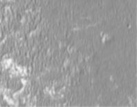
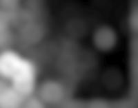
Here's the results of my fiddling with ImageJ. I started with the hirise crop from jekbradbury's post (not sure if it's full res). I resized it to 50%:
Then applied a 5 pix gaussian blur, which reduces the visibility of the smaller, traversible (?) ripples relative to the bigger ones:
Finally I applied the "variance" filter with 40 pix width, followed by a 20 pix gaussian blur and a gamma tweak:
In the final plot, dark areas have small, traversible ripples, and middle-bright areas have large ripples. The brightest areas have bedrock. This was very quick and dirty, and unfortunately I don't have time to do much more.  There's no directional info here like you'd get from FT: I've just evaluated the total variance. It's not clear if bedrock can be distinguished reliably, but I'd think it would be quite easy to measure the max brightness (after some smoothing) in a small window and say you've got bedrock if the max is above some cutoff. Discriminating dangerous from safe ripples on bedrock may be hard to do automatically. There's no directional info here like you'd get from FT: I've just evaluated the total variance. It's not clear if bedrock can be distinguished reliably, but I'd think it would be quite easy to measure the max brightness (after some smoothing) in a small window and say you've got bedrock if the max is above some cutoff. Discriminating dangerous from safe ripples on bedrock may be hard to do automatically.Anyway, this would have to be tested extensively of course... |
|||
|
|
|
|||
|
Sep 24 2008, 04:35 PM
Post
#248
|
|||
|
Senior Member Group: Moderator Posts: 4279 Joined: 19-April 05 From: .br at .es Member No.: 253 |
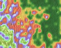
Interesting results, Fredk!
Here's what I get when applying the same process to the image I'm using on the route map.
(2.5m/pix) |
||
|
|
|
||
|
Sep 24 2008, 04:55 PM
Post
#249
|
|
|
Senior Member Group: Members Posts: 4247 Joined: 17-January 05 Member No.: 152 |
Thanks for that, Tesheiner. And now we already have one important conclusion: whatever route we take to Endeavour, we should not go via the interior of Victoria!
Seriously, I have one more comment about the route (this is for after our drivability maps are ready). It might make sense to drive as much eastwards as we can early in the drive. I mean, we know we have to make significant west-east movement, across the ripples. So perhaps we should take any opportunity we can to make progress eastwards, even if it may not look like the best direction to start (as long as we won't get completely bogged down). Then later, if the ripples worsen, we'll have already made progress east and could head south instead. Also, if a wheel goes it may become much harder to move east. Basically, the philosophy is we should move east when at all possible, and then head south when we can't move east due to big ripples. |
|
|
|
| Guest_Bobby_* |
Sep 24 2008, 04:57 PM
Post
#250
|
|
Guests |
I have a few Questions:
1. Is the area south of Victoria lower in Elevation then Victoria 2. Is the top of Endeavour lower in Elevation then the bottom of Victoria Crater??? 3. If the area is lower will we discover different bedrock or layers then we saw inside Victoria 4. Where has Pando Vanished to??? last post in June? Hope he's ok? |
|
|
|
|
Sep 24 2008, 05:08 PM
Post
#251
|
|
 Member Group: Members Posts: 813 Joined: 8-February 04 From: Arabia Terra Member No.: 12 |
Some more thoughts on the distributed computing/mechanical turk method of doing things:
Is there a really wide diversity of dune forms here, or do they all (more or less) exist somewhere on on a continuum of possible forms? If it's the latter, it might make processing of the 'identify this terrain' output data more precise, in that we can take the mean 'ripple value' of the results rather than the modal one. For example: Say a particular square has five votes for 'terrain type 3' and 2 for 'terrain type 4'. We could then claim the square is type 3.29. I am willing to do the gridding and contouring for the output data from such a project, should it get off the ground. |
|
|
|
|
Sep 24 2008, 06:02 PM
Post
#252
|
||
|
Member Group: Members Posts: 293 Joined: 22-September 08 From: Spain Member No.: 4350 |
I played with the same image than fredk using GIMP and got this:
I pixelated copies of the image to a few square sizes between 10 and 25px, stretched them from black to white and stacked them at 50% transparency (bigger dunes seem to make brighter averages, but if a square boundary catches half a dune, you get an artifact), then gaussian blurred it at 25px, adjusted brightness and contrast, applied a color degradation map and overlayed it on the original image. |
|
|
|
|
|
|
Sep 24 2008, 06:30 PM
Post
#253
|
|
|
Senior Member Group: Moderator Posts: 4279 Joined: 19-April 05 From: .br at .es Member No.: 253 |
Now, who wants to do the same with these images?
http://www.unmannedspaceflight.com/index.p...y&pid=76383 |
|
|
|
|
Sep 24 2008, 07:07 PM
Post
#254
|
|
 Member Group: Members Posts: 267 Joined: 5-February 06 Member No.: 675 |
QUOTE (jamescanvin @ Sep 23 2008, 05:29 PM) Yes, that is what I was thinking. I've started doing Fourier transforms on 256 pixel (east-west perpendicular to the ripples) slices and have confirmed to myself that I can at least detect ripples. <snip> I'm sure the signature will change significantly as the ripple size changes. It's bedtime for me now, but tomorrow I'll put the code in place to run these FT's over the whole image and then make maps of various characteristics of the Fourier profiles generated. James Nice work with the one-dimensional Fourier transform, but it seems to me that the kind of two-dimensional Fourier Transform used in image processing applications would be more useful for measuring the distance between ripples of arbitrary orientation and would also provide information on the orientation of the ripples (we can't count on their local tendency to a general N-S orientation in this part of Meridiani). I don't have the math to handle that but you might want to look into it as a possibility. Steve M |
|
|
|
|
Sep 24 2008, 08:02 PM
Post
#255
|
|
|
Senior Member Group: Members Posts: 4247 Joined: 17-January 05 Member No.: 152 |
QUOTE (Fran Ontanaya @ Sep 24 2008, 07:02 PM) I played with the same image than fredk using GIMP and got this: Nice job. I had noticed that areas with bigger dunes tend to be brighter, so a simple blurring might work. But you might need to worry about trends in suface brightness, ie some areas with ripples of size x may be brighter on average than other areas with ripples the same size. To deal with this some Fourier type method or a simple variance as I did may be more robust. |
|
|
|
|

|
Lo-Fi Version | Time is now: 29th May 2024 - 07:45 PM |
|
RULES AND GUIDELINES Please read the Forum Rules and Guidelines before posting. IMAGE COPYRIGHT |
OPINIONS AND MODERATION Opinions expressed on UnmannedSpaceflight.com are those of the individual posters and do not necessarily reflect the opinions of UnmannedSpaceflight.com or The Planetary Society. The all-volunteer UnmannedSpaceflight.com moderation team is wholly independent of The Planetary Society. The Planetary Society has no influence over decisions made by the UnmannedSpaceflight.com moderators. |
SUPPORT THE FORUM Unmannedspaceflight.com is funded by the Planetary Society. Please consider supporting our work and many other projects by donating to the Society or becoming a member. |
|