Endeavour Drive - Drivability analysis |

  |
Endeavour Drive - Drivability analysis |
 Sep 25 2008, 07:53 PM Sep 25 2008, 07:53 PM
Post
#301
|
|
|
Senior Member  Group: Members Posts: 1583 Joined: 14-October 05 From: Vermont Member No.: 530 |
QUOTE (SFJCody @ Sep 25 2008, 03:44 PM)  Now that is truly excellent!  I'm pleased to see that Oppy has already passed through a much denser patch of 'red terrain' travelling down past Erebus to Victoria than anything that lies further south! I'm pleased to see that Oppy has already passed through a much denser patch of 'red terrain' travelling down past Erebus to Victoria than anything that lies further south!Huh. Makes you wonder if Victoria would have been the destination if HiRise images had existed when they planned the trek. |
 |
 
|
|
Sep 25 2008, 08:16 PM
Post
#302
|
|
|
Senior Member Group: Members Posts: 2922 Joined: 14-February 06 From: Very close to the Pyrénées Mountains (France) Member No.: 682 |
It prove once again what Rui says : this is the trip that matters, not the destination...
-------------------- |
|
|
|
|
Sep 25 2008, 09:07 PM
Post
#303
|
|
|
Member Group: Members Posts: 258 Joined: 22-December 06 Member No.: 1503 |
The huge red zone around Victoria just illustrates my point. Red is not necessarily bad. Red just means slow down and use extreme caution. We cannot change directions very easily without getting into trouble when we are in a red zone. Like I said before
while some red zones are impassable, some are highways north and south. We just need to watch out for the odd dune going in the wrong direction, the occasional sand trap from a buried crater, and potential cliffs. There is little wrong about flat pavement in between large dunes.
The shortest distance from A to B is a straight line. Because of transit time, the shortest distance is not necessarily the shortest path. Yet, often the best thing to do is try to match that straight line as close as possible and within reason. Some of those red areas have near perfect highways between the dunes. You just don't want one of those dunes blocking the path you want to take. Furthermore, we want to do some science on the way to Endeavor. Large dunes with cobbles strewn about might be good targets. I already found a large cobble about the size of the rover much closer to mini-endeavor. Im sure there will be plenty on the way, but Im not sure how many of the really big ones will be available on the flattest of terrain. We have all wheels working at this point. There is concern about one failing soon. It might be easier dragging it over pavement than through a sand layer that is relatively flat. There are just lots of different aspects to this trip that need to be considered. We just dont want to head directly into an known type of obstacle. While some dune fields are clear obstacles, others are somewhat irrelevant despite their potential size. |
|
|
|
|
Sep 25 2008, 09:22 PM
Post
#304
|
||
 Senior Member Group: Moderator Posts: 2785 Joined: 10-November 06 From: Pasadena, CA Member No.: 1345 |
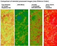
Here's a side by side comparison of some of the image techniques near Erebus Crater:
(I added the track from Astro0's post to all the images for comparison)
-Mike -------------------- Some higher resolution images available at my photostream: http://www.flickr.com/photos/31678681@N07/
|
|
|
|
|
|
|
Sep 25 2008, 09:34 PM
Post
#305
|
|
 Senior Member Group: Moderator Posts: 2262 Joined: 9-February 04 From: Melbourne - Oz Member No.: 16 |
Here are a couple of 1/4 resolution images (click for my website) with my coloured overlay.
Looks good. In fact, considering the crudeness of what I have done, I'm astonished how well it does.Just north of Erebus - I assume Purgatory is in there somewhere.  Where we are now.  James -------------------- |
|
|
|
|
Sep 25 2008, 09:39 PM
Post
#306
|
|
 Senior Member Group: Members Posts: 1229 Joined: 24-December 05 From: The blue one in between the yellow and red ones. Member No.: 618 |
Absolutely spellbinding, Mike! The oarsome foursome! (I don't know which I'd prefer to steer by, but I know which I'd prefer on my bathroom floor!
 ) )I suppose all we need is to tweak them a bit until the path we successfully followed shows as green, and the places we got stuck are red. The suspense is killing me. Ultreya! -------------------- My Grandpa goes to Mars every day and all I get are these lousy T-shirts!
|
|
|
|
|
Sep 25 2008, 11:15 PM
Post
#307
|
|
 Senior Member Group: Members Posts: 4247 Joined: 17-January 05 Member No.: 152 |
James, that's looking fantastic! Just a couple of remarks: could we see a higher-resolution crop of an area that contains extensive bedrock (eg Erebus highway) so we can see how the FT does there? Also, there are lots of areas that are almost saturated red - perhaps the colour table could be tweaked to give more gradations of red so we can see more easily what's the worst of the worst and what's the best of the worst etc?
|
|
|
|
|
Sep 25 2008, 11:41 PM
Post
#308
|
|
|
Member Group: Members Posts: 293 Joined: 22-September 08 From: Spain Member No.: 4350 |
Meh, the method I used doesn't work for flat featureless land. The area around Victoria and any ground without cracks will look red.
|
|
|
|
|
Sep 26 2008, 03:02 AM
Post
#309
|
|
 Member Group: Members Posts: 753 Joined: 23-October 04 From: Greensboro, NC USA Member No.: 103 |
James, I'm astonished, speaking as one of the 10% of the population who is red-green color deficient, that you chose shades of red and green that I can actually distinguish! What a great map!
What I find really interesting is that Purgatory does not particularly stand out. It's not like it's in the middle of a huge red area. It just highlights that we still need to be very careful even if we avoid the large concentrations of red. -------------------- Jonathan Ward
Manning the LCC at http://www.apollolaunchcontrol.com |
|
|
|
|
Sep 26 2008, 03:05 AM
Post
#310
|
|
|
Member Group: Members Posts: 139 Joined: 14-October 05 From: Toronto, Canada Member No.: 529 |
QUOTE (Fran Ontanaya @ Sep 25 2008, 06:27 AM) Bingo. By Jove I think you've got it! I like how you captured the big dune as no go (red) and still left the bed rock as drivable areas. Well done! 
-------------------- -- Robin
|
|
|
|
|
Sep 26 2008, 04:22 AM
Post
#311
|
|||
|
Senior Member Group: Moderator Posts: 2785 Joined: 10-November 06 From: Pasadena, CA Member No.: 1345 |
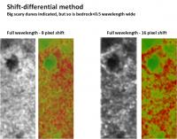
Well, after messing with this for most of the evening, I don't think the shift differential method is going to work out. I tried using 0.5 wavelength and 1 full wavelength shifts. Here are the results:
Any bedrock that is less than 1 dune wavelength wide will get indicated as "scary" due to the margin shift. I thought I could get it to cancel out but to no avail. The big scary dunes AND the bedrock zones get indicated as "no go". If anyone has ideas to improve this, be my guest. Here's what I did: 1) Paste image 2) Copy image into new layer 3) Gaussian blur both images to 1/4 wavelength (in pixels) 4) Shift first image either 0.5 or 1 full wavelength (in pixels) 5) Take difference 6) Merge layers - gaussian blur 2 x wavelength 7) Increase contrast (from lowest signal - black; highest signal = white) 7) Colorize images (green --> yellow --> red) 8) Overlay (multiply) the hi-res BW with the colorized image. Here's the image indicated above of Purgatory. Note that even the big dunes here are NOT indicated as scary when this method was applied.
*sigh* This seems appropriate about now:  Marvin_Martian_drawing.wav ( 39.69K )
Number of downloads: 272
Marvin_Martian_drawing.wav ( 39.69K )
Number of downloads: 272-Mike -------------------- Some higher resolution images available at my photostream: http://www.flickr.com/photos/31678681@N07/
|
||
|
|
|
||
|
Sep 26 2008, 04:26 AM
Post
#312
|
||
 Senior Member Group: Admin Posts: 3108 Joined: 21-December 05 From: Canberra, Australia Member No.: 615 |
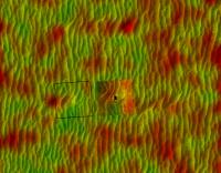
JamesCanvin - Just north of Erebus - I assume Purgatory is in there somewhere.
I compared James' image to Phil's route map and here's Purgatory in the highlighted circle. It shows up as an unremarkable spot in this image. Check out the insets - one blank and the other with Oppy's path marked.
What does that say for finding these sandtraps in advance? |
|
|
|
|
|
|
Sep 26 2008, 04:37 AM
Post
#313
|
||
|
Senior Member Group: Admin Posts: 3108 Joined: 21-December 05 From: Canberra, Australia Member No.: 615 |
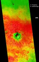
Also, here's James' map with the rover's route from Eagle to VC.
I've marked Purgatory (A) and Jammerbugt (B ).
Astro0 |
|
|
|
|
|
|
Sep 26 2008, 04:42 AM
Post
#314
|
|
|
Senior Member Group: Moderator Posts: 2785 Joined: 10-November 06 From: Pasadena, CA Member No.: 1345 |
QUOTE (Astro0 @ Sep 26 2008, 12:26 AM) It shows up as an unremarkable spot in this image. Bummer. I was really hoping the Fourier transform method would solve all the problems: big dune detection, funky dune detection, finding safe bedrock zones. Would it be possible to do some sort of double Fourier analysis? To look for a change in the regular pattern from the parallel lines? The really big sandtraps seem to have off-parallel curves. And large sweeping, well...sand-traps. -Mike -------------------- Some higher resolution images available at my photostream: http://www.flickr.com/photos/31678681@N07/
|
|
|
|
|
Sep 26 2008, 04:49 AM
Post
#315
|
|
 Senior Member Group: Admin Posts: 4763 Joined: 15-March 05 From: Glendale, AZ Member No.: 197 |
QUOTE (Juramike @ Sep 25 2008, 09:22 PM) Here's the image indicated above of Purgatory. Note that even the big dunes here are NOT indicated as scary when this method was applied. If anyone wants to relocate the highest resolution of the area, the regional location is available here at the tip of the big red arrow in an image from two Novembers ago when the HiRISE image was first released. And then Emily's full-res cropped segment of Vostok-Erebus highway that contains Purgatory is hosted here. FWIW -------------------- If Occam had heard my theory, things would be very different now.
|
|
|
|
|

|
Lo-Fi Version | Time is now: 29th May 2024 - 06:45 PM |
|
RULES AND GUIDELINES Please read the Forum Rules and Guidelines before posting. IMAGE COPYRIGHT |
OPINIONS AND MODERATION Opinions expressed on UnmannedSpaceflight.com are those of the individual posters and do not necessarily reflect the opinions of UnmannedSpaceflight.com or The Planetary Society. The all-volunteer UnmannedSpaceflight.com moderation team is wholly independent of The Planetary Society. The Planetary Society has no influence over decisions made by the UnmannedSpaceflight.com moderators. |
SUPPORT THE FORUM Unmannedspaceflight.com is funded by the Planetary Society. Please consider supporting our work and many other projects by donating to the Society or becoming a member. |
|