Endeavour Drive - Drivability analysis |

  |
Endeavour Drive - Drivability analysis |
 Sep 28 2008, 04:53 PM Sep 28 2008, 04:53 PM
Post
#391
|
|
 Senior Member  Group: Members Posts: 4247 Joined: 17-January 05 Member No.: 152 |
QUOTE (Fran Ontanaya @ Sep 27 2008, 01:13 AM)  BTW, I tried to match the distant peaks of Endeavour as seen from Cape Verde with an HRSC image. Is this right? I think A and B are right, but not C and D. Check out this post and this post. |
 |
 
|
|
Sep 28 2008, 07:22 PM
Post
#392
|
|
|
Member Group: Members Posts: 202 Joined: 9-September 08 Member No.: 4334 |
Was my "selective Gaussian" method here any good?
Is there anything else I can do to help with this analysis? All of this is amazing! |
|
|
|
|
Sep 28 2008, 08:18 PM
Post
#393
|
|
|
Member Group: Admin Posts: 976 Joined: 29-September 06 From: Pasadena, CA - USA Member No.: 1200 |
QUOTE (Vultur @ Sep 28 2008, 11:22 AM) Was my "selective Gaussian" method here any good? Is there anything else I can do to help with this analysis? All of this is amazing! If I read ypur description of the algorithm correctly the regions, after the edge prserving smoothing, are selected based on brightness (the fuzzy select). I'm not sure that ripples, bedrock and sand are distinguishable by intensity values. The currently proposed filters (variance, texture, fourier transform) try to measure "local differences" so to speak. They are therefore somewhat insensitive to the absolute values of brightness. Paolo -------------------- Disclaimer: all opinions, ideas and information included here are my own,and should not be intended to represent opinion or policy of my employer.
|
|
|
|
|
Sep 28 2008, 09:06 PM
Post
#394
|
|
|
Member Group: Admin Posts: 976 Joined: 29-September 06 From: Pasadena, CA - USA Member No.: 1200 |
Many many thanks to all who contributed so far. I want to reiterate something I want to make sure this is constantly clear. When I participate and write here on UMSF I do it as a private citizen who accidentally drives rovers on Mars. The discussion and my request for help was from me, not JPL. Therefore, your contribution will be to me, you cannot claim to have helped JPL drive the rovers or provide a traverse map to JPL. The silver lining is that as a consequence you are not liable for the actual safety of the mission.
 This starts to sound like a lawyer speak, doesn't it? Well, it isn't. It comes from me. I could have attempted to go through the official channels at JPL but decided that I much rather put my limited resources into making this experience as close as possible. This has the disadvantage that you are not talking to JPL but to me. I hope this does not discourage anybody from continuing the discussion and hard work. Just looking at the quality and sheer volume of your contributions makes me really really happy. It has been a good week on good old Earth. Paolo -------------------- Disclaimer: all opinions, ideas and information included here are my own,and should not be intended to represent opinion or policy of my employer.
|
|
|
|
|
Sep 28 2008, 09:12 PM
Post
#395
|
|
|
Member Group: Members Posts: 202 Joined: 9-September 08 Member No.: 4334 |
QUOTE (RoverDriver @ Sep 28 2008, 09:18 PM) If I read ypur description of the algorithm correctly the regions, after the edge prserving smoothing, are selected based on brightness (the fuzzy select). I'm not sure that ripples, bedrock and sand are distinguishable by intensity values. The currently proposed filters (variance, texture, fourier transform) try to measure "local differences" so to speak. They are therefore somewhat insensitive to the absolute values of brightness. Paolo OK, thanks. That's good to know. |
|
|
|
|
Sep 28 2008, 09:22 PM
Post
#396
|
||
 Senior Member Group: Moderator Posts: 2785 Joined: 10-November 06 From: Pasadena, CA Member No.: 1345 |
My final iteration for the Erebus to Etched Terrain section:
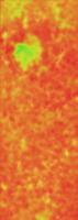
Differential image shifted 10 pixels to the E AND 5 pixels to S (0.5 wavelength of SW-NE dune) to better light up the scary curvy dunes. Colors are balanced, too. Exact Recipe: 1) Load image 2) Select rock areas (using Magic Wand): recolorize as grayscale 160/256 3) Gaussian blur 4 pixels (big dune wavelength = 22 pixels) 4) Copy layer 5) Move upper layer 10 pixels to the E and 5 pixels to the S (big dune wavelength = 22 pixels) 6) Set upper layer combination style as "Differential" 7) Merge the two layers 8) Gaussian blur 30 pixels (big dune wavelength = 22 pixels) 9) Add Curves layer (set 0/256 as black level, white level at 25/256) 10) Add Brightness/contrast layer (set Brightness +75) 12) Flatten layers: convert Image Mode to Indexed Color 13) Color table: 1/256 pixel value = Green[125/100%/100%] (Hue/Saturation/Brightness) 80/256 pixel value = Yellow[65/100%/100%] (Hue/Saturation/Brightness) 160/256 pixel value = Orange [30/100%/100%] (Hue/Saturation/Brightness) 256/256 pixel value = Red[0/100%/100%] (Hue/Saturation/Brigthness) 14) Convert Image Mode to RGB: duplicate layer 15) Reload original image 16) Combine the two images using Normal mode (original image at 30% opacity) 17) Crop slightly to remove edge artifacts -Mike -------------------- Some higher resolution images available at my photostream: http://www.flickr.com/photos/31678681@N07/
|
|
|
|
|
|
|
Sep 28 2008, 09:44 PM
Post
#397
|
|
|
Senior Member Group: Members Posts: 2922 Joined: 14-February 06 From: Very close to the Pyrénées Mountains (France) Member No.: 682 |
QUOTE (RoverDriver @ Sep 28 2008, 11:06 PM) Therefore, your contribution will be to me, you cannot claim to have helped JPL drive the rovers or provide a traverse map to JPL. I could have attempted to go through the official channels at JPL but decided that I much rather put my limited resources into making this experience as close as possible. This has the disadvantage that you are not talking to JPL but to me. I hope this does not discourage anybody from continuing the discussion and hard work. Paolo I also speak for me only (one that doesn't contribute so far but hope he'll help more on a day by day basis later on) you're statment was clear from the begining. The idea that "I" can provide you with "choices" even if you'll never choose one (or tell you did) is enough for me to feel I participate in the Exploration. Since you've started to post the feeling is different. I know you tell us what you're allowed to tell but it's much more than what we had before. And it's good to know we have an Italian driver but I'm happy Oppy is not a Ferrari; they've not be very lucky at Singapore Grand Prix today... -------------------- |
|
|
|
|
Sep 28 2008, 11:26 PM
Post
#398
|
|
|
Member Group: Members Posts: 910 Joined: 4-September 06 From: Boston Member No.: 1102 |
I like what your doing Mike, but the bigest green area on your map is a known death trap filled with fine dust (the center of Erebus).

-------------------- |
|
|
|
|
Sep 29 2008, 12:33 AM
Post
#399
|
|
|
Senior Member Group: Moderator Posts: 2785 Joined: 10-November 06 From: Pasadena, CA Member No.: 1345 |
Ahhh, but at least it's a smooth fine dust.
I think the shift-differential image technique (and Fourier technique also) will only be able to help avoid areas with dune crests. There will still be a visual inspection part that will be necessary to winnow the routes down further. But at least there should be significantly less real estate to have to examine closely. -Mike -------------------- Some higher resolution images available at my photostream: http://www.flickr.com/photos/31678681@N07/
|
|
|
|
|
Sep 29 2008, 01:22 AM
Post
#400
|
||
|
Senior Member Group: Moderator Posts: 2785 Joined: 10-November 06 From: Pasadena, CA Member No.: 1345 |
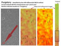
The curved dunes usually come in pairs. (There is a curved trough, with two crests).
By shifting 10 pixels to the E and then 5 pixels to the S, it appears that you can get maximal brightness signal from the SW-NE oriented dunes after taking the differential - these are the ones like Purgatory. These will get lumped into the category of "big, scary" dunes. But it is comforting to know that Purgatory Dune and it's buddies (and there are several in the area) will get indicated as "RED = Caution!" Here are the comparison images of Purgatory Dune from ElkGroveDan's post (here) and images from the "Differential Shift 10E5S Method". Purgatory and friends indicated by black arrows:
(In retrospect, this was kinda scary.) -Mike (I don't know if a Fourier analysis would pick this up. It's only a repeating number of 2 instead of a regular set.) -------------------- Some higher resolution images available at my photostream: http://www.flickr.com/photos/31678681@N07/
|
|
|
|
|
|
|
Sep 29 2008, 01:26 AM
Post
#401
|
||
|
Senior Member Group: Moderator Posts: 2785 Joined: 10-November 06 From: Pasadena, CA Member No.: 1345 |
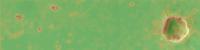
Here is the Eagle Crater to Endurance area:
(This was used to set the "parking lot" color level.) -Mike -------------------- Some higher resolution images available at my photostream: http://www.flickr.com/photos/31678681@N07/
|
|
|
|
|
|
|
Sep 29 2008, 01:31 AM
Post
#402
|
||
|
Member Group: Members Posts: 293 Joined: 22-September 08 From: Spain Member No.: 4350 |
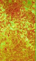
Some area South of Victoria. There are red artifacts on very flat patches at the top left side.
This is about the maximum size I can work with.
I saved a raw version here (7 MB), an high quality version here (10 MB) and some smaller resolution images here. I did an edges map, but I find it more confusing than informative. At this area I don't see many long troughs, and they could be even dangerous to reach. |
|
|
|
|
|
|
Sep 29 2008, 01:31 AM
Post
#403
|
||
|
Senior Member Group: Moderator Posts: 2785 Joined: 10-November 06 From: Pasadena, CA Member No.: 1345 |
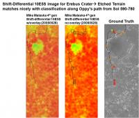
Shift Differential 10E5S Erebus Crater to Etched Terrain prediction compared with Ground Truth classification based on Oppy's images:
-Mike -------------------- Some higher resolution images available at my photostream: http://www.flickr.com/photos/31678681@N07/
|
|
|
|
|
|
|
Sep 29 2008, 02:41 AM
Post
#404
|
|||
|
Senior Member Group: Moderator Posts: 2785 Joined: 10-November 06 From: Pasadena, CA Member No.: 1345 |
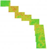
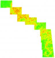
Here is (I think) part of the putative route from Explorer Crater towards Endeavor.
This is from Tman's image higher resolution linked to in this post (this thread, post 123) (This is the only chunk that I could find in jpeg format of the region beyond Victoria.) Since the big dune wavelength was only 10 pixels (I assume this is at ca. 50% resolution) I used 5E2S for the differential shift. Here are the results. (Edge effects were a pain, Explorer crater just beyond the NW corner had to get clipped) Overlay with terrain (left) and Colorized only (right):
And getting back to Floyd's post, in the second "box" to the SE from Explorer crater (off screen, sorry!) there is a green zone surrounded by big scary dunes (in red). This central green zone could be another Erebus style fine dust deathtrap and should be examined carefully (or avoided). -Mike -------------------- Some higher resolution images available at my photostream: http://www.flickr.com/photos/31678681@N07/
|
||
|
|
|
||
|
Sep 29 2008, 04:53 AM
Post
#405
|
|
 Senior Member Group: Members Posts: 2228 Joined: 1-December 04 From: Marble Falls, Texas, USA Member No.: 116 |
I remain blown away by the cleverly calculated maps posted by so many talented people here. I can't choose a favorite among them. It will be very fascinating to learn which were deemed the most helpful by the navigators.
QUOTE (RoverDriver @ Sep 28 2008, 03:06 PM) ... Therefore, your contribution will be to me, you cannot claim to have helped JPL drive the rovers or provide a traverse map to JPL. The silver lining is that as a consequence you are not liable for the actual safety of the mission. ...what climber said... Hopefully, most here understand the rules you've made exceptionally clear from the beginning. I'm sure most of us are quite comfortable with those conditions. 
-------------------- ...Tom
I'm not a Space Fan, I'm a Space Exploration Enthusiast. |
|
|
|
|

|
Lo-Fi Version | Time is now: 29th May 2024 - 11:54 PM |
|
RULES AND GUIDELINES Please read the Forum Rules and Guidelines before posting. IMAGE COPYRIGHT |
OPINIONS AND MODERATION Opinions expressed on UnmannedSpaceflight.com are those of the individual posters and do not necessarily reflect the opinions of UnmannedSpaceflight.com or The Planetary Society. The all-volunteer UnmannedSpaceflight.com moderation team is wholly independent of The Planetary Society. The Planetary Society has no influence over decisions made by the UnmannedSpaceflight.com moderators. |
SUPPORT THE FORUM Unmannedspaceflight.com is funded by the Planetary Society. Please consider supporting our work and many other projects by donating to the Society or becoming a member. |
|