Endeavour Drive - Drivability analysis |

  |
Endeavour Drive - Drivability analysis |
 Oct 3 2008, 05:00 AM Oct 3 2008, 05:00 AM
Post
#466
|
|
 The Insider  Group: Members Posts: 669 Joined: 3-May 04 Member No.: 73 |
QUOTE (Bobby @ Sep 24 2008, 09:57 AM)  I have a few Questions: ... 4. Where has Pando Vanished to??? last post in June? Hope he's ok? Hey Bobby, can I answer your question #4?!!  I'm ok, just lurking here every once in a while. I must find some time for this stuff, again, soon, or I'll miss the greatest mapping project in the history of the multiverse... umm... or just to keep ustrax in line if nothing else.  (just looked up my old alter ego... holy **** has it been that long?!?) (just looked up my old alter ego... holy **** has it been that long?!?)I'm checking the drivability analysis that's going on here and this stuff is just amazing. Ustrax -- you must already be dreaming what's next after Endurance/Ithaca, as we already know we're going there! 
|
 |
 
|
|
Oct 3 2008, 05:31 AM
Post
#467
|
||
 Senior Member Group: Members Posts: 2228 Joined: 1-December 04 From: Marble Falls, Texas, USA Member No.: 116 |
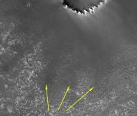
QUOTE (Oersted @ Oct 2 2008, 03:02 AM) Fantastic to see those hitherto hidden rays emanating out from Victoria. It all looked like a uniform ripple field before, but now some avenues might be opening up. This thread has had many comments about the hidden "rays" that have been made apparent by the various image processing techniques being used here. I'd like to point out that, while much of the processing being done is amazing, those "ray" features are rather obvious on the original HiRise gray scale imagery. We can easily see those textural areas of small ripples extending into the region of larger ripples to the south. I am attaching a highlighted, cropped, HiRise image at 1/8th scale as evidence.
For me, the fact that many of the processed images outline those areas as safe for driving is one indication that the processing analysis is working properly. I think the value of spatially/texturally analyzing the imagery will make itself apparent in areas much less obvious than these "rays." Finally, I really doubt these features are rays of Victoria Crater. They are areas of smaller ripples within a region of mostly large ripples, all of which were formed very recently compared to the extremely old age of Victoria Crater. Perhaps some underlying feature of Victoria's ancient bedrock debris apron could affect the ripple sizes nearby, but I'm not sure how that might work. -------------------- ...Tom
I'm not a Space Fan, I'm a Space Exploration Enthusiast. |
|
|
|
|
|
|
Oct 3 2008, 06:31 AM
Post
#468
|
|
 Senior Member Group: Members Posts: 1229 Joined: 24-December 05 From: The blue one in between the yellow and red ones. Member No.: 618 |
I agree, Tom.
We should not imagine that the best course traverses only sand. Scientifically, the best course will be on the exposed bedrock, diverting only to avoid "sand traps" or to visit interesting cobbles on the sand. -------------------- My Grandpa goes to Mars every day and all I get are these lousy T-shirts!
|
|
|
|
|
Oct 3 2008, 07:05 AM
Post
#469
|
|
 Special Cookie Group: Members Posts: 2168 Joined: 6-April 05 From: Sintra | Portugal Member No.: 228 |
QUOTE (Pando @ Oct 3 2008, 06:00 AM) Ustrax -- you must already be dreaming what's next after Endurance/Ithaca, as we already know we're going there! Pando...I've missed you!  And yes...it has been that long but what a fantastic years these have been so far! About what's next...huumm...I'd prefer not to answer that...but now that Oppy is sent on a new journey maybe it is time to look at Gusev's HiRise images... -------------------- "Ride, boldly ride," The shade replied, "If you seek for Eldorado!"
Edgar Alan Poe |
|
|
|
|
Oct 3 2008, 11:40 AM
Post
#470
|
|
 Senior Member Group: Moderator Posts: 2785 Joined: 10-November 06 From: Pasadena, CA Member No.: 1345 |
QUOTE (ustrax @ Oct 3 2008, 03:05 AM) now that Oppy is sent on a new journey maybe it is time to look at Gusev's HiRise images... You thinkin' Oppy can make it all the way to Gusev? -------------------- Some higher resolution images available at my photostream: http://www.flickr.com/photos/31678681@N07/
|
|
|
|
|
Oct 3 2008, 04:14 PM
Post
#471
|
|||
 Member Group: Members Posts: 267 Joined: 5-February 06 Member No.: 675 |
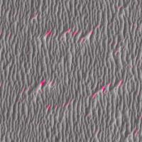
QUOTE (PDP8E @ Sep 29 2008, 09:32 PM) hi all, here is a 'Purgatory' animated gif that demos a version 0.2 of the DEM model I have been working on. Green is drivable Dark is not Purgatory is slightly left and south of center (bright in the HiRise / dark in the DEM model) Cheers I decided to try a simple analysis to this image to see if I could identify the purgatory type spots where ripples come to a dead end. My technique found some -- but by no means all -- of the dead ends.
I did it in photoshop by applying two 15 pixel motion blurs along the general North/South trend of the ripples, subtracting that from the original image, taking the inverse of that difference, taking the lighter of the two versions of the difference, clipping out the fainter indications (that may be the reason it misses some), blurring the result to make it larger and then adjusting the range from gray to white, and applying the result to the a (magenta-cyan) channel of a lab color image. As I was writing this, I thought of inserting some of the fainter indications ( a less strongly clipped version) into the b (yellow-blue) channel and found it catches more of the misalignments, many of which are not significant, but some may be.
It's simpler than the FFT approach I had mentioned before, identifies some of the problem areas, and places them in the context of the original image. I imagine it could be applied to a larger area. Steve M |
||
|
|
|
||
|
Oct 3 2008, 04:26 PM
Post
#472
|
|
|
Senior Member Group: Moderator Posts: 2785 Joined: 10-November 06 From: Pasadena, CA Member No.: 1345 |
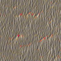
Ahhhh, a linear blur! Brilliant!
It might be interesting to shift one of the images to the N or S by a few pixels. The N-S waves will not be affected, but the off-angle pixels will give more of a difference and should result in a more enhanced color. -Mike -------------------- Some higher resolution images available at my photostream: http://www.flickr.com/photos/31678681@N07/
|
|
|
|
|
Oct 3 2008, 04:34 PM
Post
#473
|
|
 Senior Member Group: Admin Posts: 4763 Joined: 15-March 05 From: Glendale, AZ Member No.: 197 |
Brilliant Steve.
Though I would add that this only has relevance in the large dune "red" zones from James' and others' images. What I mean by that is, in the smaller dune areas such as we encountered around Vostock there is likely "purgatory" shaped dune geometry, but it becomes irrelevant since the wheel size compared to dune size allows the rover to coast right over those. In fact it might be interesting to go back and look at the early route and see how many times Opportunity did in fact cross perpendicular "purgatory" shaped dunes that were small in size. There must have been a few. -------------------- If Occam had heard my theory, things would be very different now.
|
|
|
|
|
Oct 3 2008, 05:31 PM
Post
#474
|
|
|
Member Group: Members Posts: 293 Joined: 22-September 08 From: Spain Member No.: 4350 |
QUOTE (Juramike @ Oct 3 2008, 06:26 PM) It might be interesting to shift one of the images to the N or S by a few pixels. I've seen that work in a test I did, 2px shift after detecting edges then clearing the noise, but couldn't replicate it later.  |
|
|
|
|
Oct 3 2008, 06:06 PM
Post
#475
|
|
|
Member Group: Admin Posts: 976 Joined: 29-September 06 From: Pasadena, CA - USA Member No.: 1200 |
QUOTE (Fran Ontanaya @ Oct 3 2008, 09:31 AM) I've seen that work in a test I did, 2px shift after detecting edges then clearing the noise, but couldn't replicate it later. Gabor filters do that by employing a battery of convolution kernels. It is pretty CPU intensive and well beyond the scope of what I was asking. If you want to try it, that is fine, but I have seen enough results here that will help a lot once we get the new HiRISE down. The reson for my silence is because we are still in the process of evaluating the terrain to determine the initial course towards Endeavour. If you are getting bored and your fingers are itching to do something here's an exercise for you: in the area south of Victoria find a location where you believe there is the longest stretch of flat terrain, without any obstacles in a reasonably wide corridor (50m?), where we could sequence the longest possible drive. Paolo -------------------- Disclaimer: all opinions, ideas and information included here are my own,and should not be intended to represent opinion or policy of my employer.
|
|
|
|
| Guest_Oersted_* |
Oct 3 2008, 06:41 PM
Post
#476
|
|
Guests |
I think Paolo just asked you guys to suggest a.... - route
|
|
|
|
|
Oct 3 2008, 06:53 PM
Post
#477
|
|
|
Senior Member Group: Moderator Posts: 2785 Joined: 10-November 06 From: Pasadena, CA Member No.: 1345 |
Exciting!
Does anyone know of an obvious feature in the HiRise images S of Victoria that could be used for a scale? (A 50 m size crater would be handy!) -Mike -------------------- Some higher resolution images available at my photostream: http://www.flickr.com/photos/31678681@N07/
|
|
|
|
|
Oct 3 2008, 07:01 PM
Post
#478
|
|
|
Senior Member Group: Members Posts: 2922 Joined: 14-February 06 From: Very close to the Pyrénées Mountains (France) Member No.: 682 |
I understand the question as a single drive where we know how wide the corridor has to be but not the lenght. Regarding actual power and puting every ressource on the drive, what do you think we can plan for? 300 metres?
-------------------- |
|
|
|
|
Oct 3 2008, 07:05 PM
Post
#479
|
||
|
Newbie Group: Members Posts: 12 Joined: 29-September 05 Member No.: 517 |
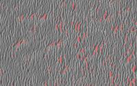
QUOTE (SteveM @ Oct 3 2008, 12:14 PM) I decided to try a simple analysis to this image to see if I could identify the purgatory type spots where ripples come to a dead end. My technique found some -- but by no means all -- of the dead ends. Quite nice, Steve. :-) Here is the first attempt of mine that looks like anything, for comparison, of a similar area. All I've really done is subtract out what I think of as 'benign' ripples, essentially the straight and narrow ones, leaving what the algorithm sees as large and/or curved ripples to get coded red. Endless possibilities for refinement but don't know if I'll pursue it. Mostly I wanted to be able to see a large-area dune-field with more red in the dangerous areas and less going on where there appear to be numerous paths through. It almost looks like something now when perusing the entire Vostok-Erebus swath -- but that's a little too much to post!
|
|
|
|
|
|
|
Oct 3 2008, 07:14 PM
Post
#480
|
|
|
Member Group: Members Posts: 808 Joined: 10-October 06 From: Maynard Mass USA Member No.: 1241 |
hi,
while I am waiting for my little computer to ker-chunk its way through 300MB of Victoria southward, I thought I share this image with you. It is a winner in so manner categories, but especially these:
http://farm4.static.flickr.com/3004/290967...44bacb547_o.jpg My terrain analysis should be done sometime tonight <post it then> Cheers -------------------- CLA CLL
|
|
|
|
|

|
Lo-Fi Version | Time is now: 29th May 2024 - 05:53 PM |
|
RULES AND GUIDELINES Please read the Forum Rules and Guidelines before posting. IMAGE COPYRIGHT |
OPINIONS AND MODERATION Opinions expressed on UnmannedSpaceflight.com are those of the individual posters and do not necessarily reflect the opinions of UnmannedSpaceflight.com or The Planetary Society. The all-volunteer UnmannedSpaceflight.com moderation team is wholly independent of The Planetary Society. The Planetary Society has no influence over decisions made by the UnmannedSpaceflight.com moderators. |
SUPPORT THE FORUM Unmannedspaceflight.com is funded by the Planetary Society. Please consider supporting our work and many other projects by donating to the Society or becoming a member. |
|