Tracks Material Colors |

  |
Tracks Material Colors |
 Jun 20 2005, 02:39 AM Jun 20 2005, 02:39 AM
Post
#16
|
|
|
Senior Member  Group: Members Posts: 2998 Joined: 30-October 04 Member No.: 105 |
Great, we're starting to get MIs on the Purgatory material; time to browse Exploratorium.
There is indeed something (in my best Elmer Fudd voice) verwy, verwy scroowey here. Examining it will help understand the geology as well as help Oppy get around without getting stuck... --Bill -------------------- |
 |
 
|
|
Jun 20 2005, 04:54 AM
Post
#17
|
|
|
Senior Member Group: Members Posts: 1870 Joined: 20-February 05 Member No.: 174 |
The Meridiani units cover an area vaguely the size of Texas, with the hematite-rich surface a portion the size of Oklahoma. There's etched terrains to the north as well as the south, and I expect the evaporite unit we have explored extends for some hundreds of kilometers. We see them exposed in the eges of kilometer(s) across "dimple" craters like one about 3 km north of Endurance (and huge ones north of the landing ellipse).
There's a spectacular crater somewhere off to the south west with evaporite unit exposed in the rim much as at Victoria crater, dark basaltic sand covered crater walls below the white evaporite layer, and a very well defined topographic bench of what appears to be an entirely separate lower evaporite layer maybe 50 or 100 meters below the near-sruface one, and then a spectacular "reticulated" network patterned dune mass in the crater floor below the second evaporite layer. I keep wondering what the more erodible layer is between the evaporite deposits, but we'll probably never know from Opportunity's data. I don't expect we'll revisit Opportunity's landing site for a long time. Future missions will probably go to the spectacular dissected badlands to the northeast where multiple different geologic layers of the Meridiani terrains as well as the cratered terrains of Sinus Meridiani are exposed. Too hazardous for an airbag lander, but wonderful for a smart terrain-avoidance navigating system like MSL is supposed to be. |
|
|
|
|
Jun 20 2005, 05:46 AM
Post
#18
|
|
 Senior Member Group: Members Posts: 2492 Joined: 15-January 05 From: center Italy Member No.: 150 |
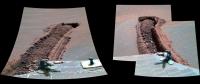
QUOTE (Bob Shaw @ Jun 19 2005, 08:57 PM) Those microscopic pictures are interesting - is it a vertical panorama of three images?  No (sorry for confusion, I have to explain a little bit); the image is divided in 2 sections: upper and lower portions show two different sites. On the left, HazCam images give the context for MI images on the right side, taken approximately at the same time... Moreover, in the upper/right, I stitched two different MI images of the track in order to minimize the shadowed terrain. 
-------------------- I always think before posting! - Marco -
|
|
|
|
|
Jun 20 2005, 10:55 AM
Post
#19
|
|
 Member Group: Members Posts: 362 Joined: 12-June 05 From: Kiama, Australia Member No.: 409 |
QUOTE (edstrick @ Jun 20 2005, 03:54 PM) The Meridiani units cover an area vaguely the size of Texas, with the hematite-rich surface a portion the size of Oklahoma. There's etched terrains to the north as well as the south, and I expect the evaporite unit we have explored extends for some hundreds of kilometers. We see them exposed in the eges of kilometer(s) across "dimple" craters like one about 3 km north of Endurance (and huge ones north of the landing ellipse). There's a spectacular crater somewhere off to the south west with evaporite unit exposed in the rim much as at Victoria crater, dark basaltic sand covered crater walls below the white evaporite layer, and a very well defined topographic bench of what appears to be an entirely separate lower evaporite layer maybe 50 or 100 meters below the near-sruface one, and then a spectacular "reticulated" network patterned dune mass in the crater floor below the second evaporite layer. The April 2004 Press release might shed some light on this. The rock bounce was speculated to have possibly come from here QUOTE Opportunity's miniature thermal emission spectrometer indicates that the main ingredient in Bounce Rock is a volcanic mineral called pyroxene, said science-team collaborator Deanne Rogers of Arizona State University, Tempe. The Mössbauer spectrometer also identified pyroxene in the rock. The high proportion of pyroxene makes it unlike not only any other rock studied by Opportunity or Spirit, but also unlike the volcanic deposits mapped extensively around Mars by a similar spectrometer on NASA's Mars Global Surveyor orbiter, Rogers said. Thermal infrared imaging by another orbiter, Mars Odyssey, suggests a possible origin for Bounce Rock. An impact crater about 25 kilometers wide (16 miles wide) lies about 50 kilometers (31 miles) southwest of Opportunity. The images show that some rocks thrown outward by the impact that formed that crater flew as far as the distance to the rover. "Some of us think Bounce Rock could have been ejected from this crater," Rogers said. http://marsrovers.jpl.nasa.gov/newsroom/pr.../20040415a.html Could be a clue as to what is under the evaporite layers |
|
|
|
|
Jun 20 2005, 10:13 PM
Post
#20
|
||||
|
Junior Member Group: Members Posts: 33 Joined: 13-April 05 Member No.: 232 |
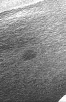
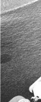
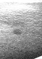
While we wait (hope) for colour pictures of that strange dark spot on the dune -
These images are cropped from navcam photos taken on the 18th - 1N172043947EFF55V4P1914L0M1 1N172043947EFF55V4P1914R0M1 1N172043999EFF55V4P1914R0M1 with brightness and contrast boosted, and then the application of the remove dust/scratches feature from Adobe Deluxe (best I've got, I'm afraid). What they seem to me to suggest is that the spot might have a tail – on its downslope side, away from the dune crest, there are three little blots in a line. And the downslope border of the spot seems relatively straighter, whereas the upslope border is more semicircular. (There's a hint of these features in the more recent navcam images, if someone could enhance them better). I wonder what the implications of this tail would be for the nature of the spot?
Attached thumbnail(s)
|
|||
|
|
|
|||
|
Jun 21 2005, 01:07 AM
Post
#21
|
|
|
Senior Member Group: Members Posts: 1870 Joined: 20-February 05 Member No.: 174 |
Abalone, discussing Bounce rock says: Could be a clue as to what is under the evaporite layers...
Indeed, ancient cratered terrains of Meridiani Sinus underly the evaporite layers, together with younger but still ancient (presumably) basaltic lava flows, intrusions, whatever. The whole layercake stack of the Meridiani sedimentary units was deposited on top of the ancient terrain, and large post-sedimentary craters like the possible source of Bounce undoubtably penetrated the entire layercake and took out the plate under it and part of the table too <grin>. What I'm more interested in is what is in the layercake other than the evaporite rock: top: (Missing layers) / Basalt sand of unknown origin (with blueberries) Sulfate evaporite rock unknown mechanically weak layer under evaporite rock More sulfate evaporite rock (exposed in that zoned crater I mentioned) More layers of Meridiani softer and maybe harder sediments Volcanic flows and intrusions of Meridiani highlands Bot: Impact breccias and water-deposited debris of old igneous rocks of Meridiani. Something like that... My impression is that the unit under the evporite rock is gutless.. so weak it doesn't survive ejection in cratering like at Endurance and is not at all clearly exposed in the lower part of the crater, so we really don't know if it's basaltic sand or what. |
|
|
|
|
Jun 21 2005, 05:23 AM
Post
#22
|
|
|
Senior Member Group: Members Posts: 2492 Joined: 15-January 05 From: center Italy Member No.: 150 |
QUOTE (Astrophil @ Jun 20 2005, 10:13 PM) While we wait (hope) for colour pictures of that strange dark spot on the dune - ... I have an hypothesys: could be the dark spot a "tiny crater" completely filled with fresh (darker) sand? 
-------------------- I always think before posting! - Marco -
|
|
|
|
|
Jun 21 2005, 07:05 AM
Post
#23
|
|
 Senior Member Group: Members Posts: 3419 Joined: 9-February 04 From: Minneapolis, MN, USA Member No.: 15 |
Hmmm... could be. But I doubt either the lighter drift material or the darker "stained" material are very fresh.
The stain might be the remnants of a rock or clod tossed out from a nearby impact, that made a crater in the drift a *long* time ago. The drift built up, covering the crater and the clod that produced it, and now the new prevailing winds are deflating that old drift and exposing its remnants. Or perhaps a small impact produced a little crater in a light-colored drift, and that event was followed for a little while by a change in wind that deposited a darker dust. Now, the old drift is being deflated, the darker layer has been blown off of the remnant drift but the dark dust that once filled it is visible in what used to be the very bottom of a larger hole. I *don't* believe it was a fairly recent crater that was filled in with dark dust, because if that had happened, we'd see more evidence of mantling of other features by this dark dust. And we really don't see any major layers of this shade of dust anywhere else that you could state with any certainty is a part of the same material as the "stain." So much of the Martian surface is being deflated at larger scales, as is obvious from a lot of the orbital imagery, that it shouldn't be surprising to see surface deflation occurring at local levels, too. -the other Doug -------------------- The trouble ain't that there is too many fools, but that the lightning ain't distributed right. -Mark Twain
|
|
|
|
|
Jun 21 2005, 09:59 AM
Post
#24
|
||
|
Member Group: Members Posts: 362 Joined: 12-June 05 From: Kiama, Australia Member No.: 409 |
From this it looks like there is some structural variation in the dune that appears to coincide roughly with the dune top. The wheels appear to have sunk in rather suddenly not dig in gradually. I am assuming that from the shape of the dunes that the eastern side in more likely to be on the down wind side of the dunes and that is where the sand seems less consolidated.
Richard
Attached thumbnail(s)
|
|
|
|
|
|
|
Jun 21 2005, 01:42 PM
Post
#25
|
|
 Senior Member Group: Members Posts: 2488 Joined: 17-April 05 From: Glasgow, Scotland, UK Member No.: 239 |
The freckle on the dune - a better description than spot, I think! - appears very circular to me, which implies something has acted which radiates out from a central point.
So: Mini-impact - followed by infill Eruption from beneath - a slow exudation from below Alteration due to volatiles - hail/snow A N Other As ever, the proof of the pudding will be in the numbers/size distribution etc. Does anyone have any idea as to the likely age of the surface we're travelling across? Crater-counting would suggest fairly young, but as the distribution of craters seems to fall sharply off at about the 10m mark (which leads me back to previous discussions re the non-linear population of impactors) I woud like to be convinced before I assume that we're on a young surface. Of course, we could be on an old evaporite surface which has been gently deflated to reveal atypical 'young' features (which the blueberries imply may have happened). If we're looking at (on average) an ancient, deflating surface then wind patterns may have changed over time and there could be 'nodes' of trapped aoelian deposits which are now being revealed (and which may have a different composition to current surface drifts). My gut feeling is that we shouldn't make assumptions about Martian features simply because they look so like Terrestrial ones without taking a hefty reality-check from time to time! -------------------- Remember: Time Flies like the wind - but Fruit Flies like bananas!
|
|
|
|
|
Jun 21 2005, 04:48 PM
Post
#26
|
|
|
Member Group: Members Posts: 477 Joined: 2-March 05 Member No.: 180 |
QUOTE (abalone @ Jun 21 2005, 04:59 AM) From this it looks like there is some structural variation in the dune that appears to coincide roughly with the dune top. The wheels appear to have sunk in rather suddenly not dig in gradually. I am assuming that from the shape of the dunes that the eastern side in more likely to be on the down wind side of the dunes and that is where the sand seems less consolidated. Richard Very nice. Interesting stuff to see: On the left side, it looks like it just flat out sunk in all at once. On the right though, it almost looks like there are "steps" - the wheels were riding fine on the duracrust, when they sunk in slightly, made maybe a half rotation, and then sunk in as deep as the left wheels. And on the left, it looks like the sink-in point is about where the dune crest is. It is odd too - the middle wheel there didn't sink in - it looks like it was on top of the dune the entire time. Quite a nice image there. |
|
|
|
|
Jun 23 2005, 06:23 AM
Post
#27
|
|
|
Senior Member Group: Members Posts: 2492 Joined: 15-January 05 From: center Italy Member No.: 150 |
Interesting new image of the east track (Sol495, not really new!), showing the transition between surface and deep... layers here are probably due to wheel digging, lot of BB on the wall!
 Cannot wait for new images from more advanced portion, I want to better see dark spots in the deep! 
-------------------- I always think before posting! - Marco -
|
|
|
|
|
Jun 23 2005, 02:17 PM
Post
#28
|
|
|
Senior Member Group: Members Posts: 1636 Joined: 9-May 05 From: Lima, Peru Member No.: 385 |
The dark stain on the dunes might probably be distribuited by water rather than wind on the old times. I have seen many beaches with pattern of dark stain which were shapped by the water flux or movement force.
Rodolfo |
|
|
|
|
Jun 23 2005, 05:38 PM
Post
#29
|
||
 Junior Member Group: Members Posts: 59 Joined: 13-February 05 From: Germany - NRW Member No.: 168 |
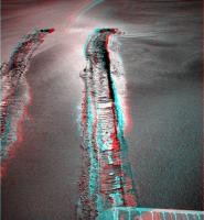
Just made a nice view of the "stuck track" from sol 487+489

Attached thumbnail(s)
|
|
|
|
|
|
|

|
Lo-Fi Version | Time is now: 27th May 2024 - 06:00 AM |
|
RULES AND GUIDELINES Please read the Forum Rules and Guidelines before posting. IMAGE COPYRIGHT |
OPINIONS AND MODERATION Opinions expressed on UnmannedSpaceflight.com are those of the individual posters and do not necessarily reflect the opinions of UnmannedSpaceflight.com or The Planetary Society. The all-volunteer UnmannedSpaceflight.com moderation team is wholly independent of The Planetary Society. The Planetary Society has no influence over decisions made by the UnmannedSpaceflight.com moderators. |
SUPPORT THE FORUM Unmannedspaceflight.com is funded by the Planetary Society. Please consider supporting our work and many other projects by donating to the Society or becoming a member. |
|