Last stops around Victoria, before the Long Trek |

  |
Last stops around Victoria, before the Long Trek |
 Oct 15 2008, 05:28 AM Oct 15 2008, 05:28 AM
Post
#181
|
|
|
Senior Member  Group: Moderator Posts: 4279 Joined: 19-April 05 From: .br at .es Member No.: 253 |
QUOTE (mhoward @ Oct 14 2008, 09:40 PM)  And I guess somethings broken in the update process, as Exploratorium doesn't seem to be updating.  Edit: new images down. I guess the pipeline is working after all. Not completely; the hazcams are still missing and they were downlinked before the available navcams. Images from the previous site are missing too. Edited: Today's imaging plan includes these mosaics but no driving. I guess the pancam one is for LBS imaging and once finished we'll leave Victoria for good. 01680::p1900::01::2::0::0::2::0::4::nav_2x1_deckCheck_pri61 01680::p1953::02::2::0::0::2::0::4::nav_1x1_az_180_1_bpp_LUT3_pri57 01680::p2364::19::3::0::0::3::1::7::pancam_Victory_3x1_L2 |
 |
 
|
|
Oct 15 2008, 08:27 AM
Post
#182
|
||
 Senior Member Group: Members Posts: 1084 Joined: 19-February 05 From: Close to Meudon Observatory in France Member No.: 172 |
...and once finished we'll leave Victoria for good.
What about having the last look at Sofi ("Explorer") crater ? I'd love to see a last view of Victoria across Sofi before leaving... and see up close the interface between the rims of Victoria and Sofi with some exposed layers on both sides 
|
|
|
|
|
|
|
Oct 15 2008, 09:41 AM
Post
#183
|
||
|
Founder Group: Chairman Posts: 14432 Joined: 8-February 04 Member No.: 1 |
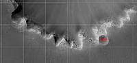
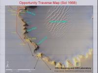
In his DPS presentation yesterday, Steve suggested there would be one stop after this one - (C on the attached image) and then we're gone.
Attached thumbnail(s)
|
|
|
|
|
|
|
Oct 15 2008, 01:28 PM
Post
#184
|
||
 Junior Member Group: Members Posts: 57 Joined: 17-May 06 From: Houston, Texas Member No.: 776 |
QUOTE (vikingmars @ Oct 15 2008, 03:27 AM) ...and once finished we'll leave Victoria for good. What about having the last look at Sofi ("Explorer") crater ? I'd love to see a last view of Victoria across Sofi before leaving... and see up close the interface between the rims of Victoria and Sofi with some exposed layers on both sides
I would like to see that as well. It would be interesting to see the impact boundary between the two craters. -------------------- |
|
|
|
|
|
|
Oct 15 2008, 02:04 PM
Post
#185
|
|
 Member Group: Members Posts: 593 Joined: 20-April 05 Member No.: 279 |
Would the boundary be worth it? Obviously Victoria predates Sofi, and the most recent activity appears to be the erosion and cape-and-baying of Victoria, perhaps by 100m diameter. As Sofi has not yet been cut by the advancing erosion, what benefits are likely in studying the smaller crater?
Andy |
|
|
|
|
Oct 15 2008, 02:17 PM
Post
#186
|
|
 Senior Member Group: Moderator Posts: 2785 Joined: 10-November 06 From: Pasadena, CA Member No.: 1345 |
I'd like a stop by Sofi as well.
I think it would be really interesting to get a compare/contrast of Sofi vs. Victoria. Especially to see how the impact rim of Sofi is eroding out into Victoria (how fractured is it? Did the Sofi impact compression make the Victoria side erode faster or slower?). The potential for dramatic pictures is also worthwhile. Neat angles of Sofi in the foreground with Victoria. (I thought the Sputnik crater images were pretty cool.) And you might get a nice shot of Duck Bay (could we see Oppy's tracks?) from across Victoria. (Is there a wire I can pull to signal a stop?) -Mike -------------------- Some higher resolution images available at my photostream: http://www.flickr.com/photos/31678681@N07/
|
|
|
|
|
Oct 15 2008, 03:06 PM
Post
#187
|
|
|
Founder Group: Chairman Posts: 14432 Joined: 8-February 04 Member No.: 1 |
If we stop every time someone says 'that's interesting' between here and Endeavour - it'll take 2,000 years, not 2.
|
|
|
|
|
Oct 15 2008, 03:18 PM
Post
#188
|
|
|
Senior Member Group: Members Posts: 1084 Joined: 19-February 05 From: Close to Meudon Observatory in France Member No.: 172 |
QUOTE (djellison @ Oct 15 2008, 05:06 PM) If we stop every time someone says 'that's interesting' between here and Endeavour - it'll take 2,000 years, not 2. It reminds me : "133:09:15 Shepard: I don't think we'll have time to go up there." "133:09:16 Mitchell: Oh, let's give it a whirl. Gee whiz. We can't stop without looking into Cone Crater. (Garbled) everything if we don't get there." Well... I'm on Mitchell's side !  |
|
|
|
|
Oct 15 2008, 03:38 PM
Post
#189
|
|
|
Founder Group: Chairman Posts: 14432 Joined: 8-February 04 Member No.: 1 |
Cone Crater probably isn't a good example, given that they couldn't really find it and never made it
Put it this way - if I had to make a choice between stop 'C' - and Explorer crater - I would say 'C'. You have to draw a line somewhere, really. Doug |
|
|
|
|
Oct 15 2008, 04:00 PM
Post
#190
|
||
|
Senior Member Group: Moderator Posts: 4279 Joined: 19-April 05 From: .br at .es Member No.: 253 |
Oh, we are 100% in back-seat driving mode, aren't we?
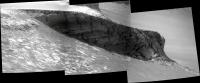
Meanwhile, here's Cape Victory as seen by the pancam (L2 filter) "this evening" (sol 1680).
|
|
|
|
|
|
|
Oct 15 2008, 04:12 PM
Post
#191
|
|
 Senior Member Group: Admin Posts: 4763 Joined: 15-March 05 From: Glendale, AZ Member No.: 197 |
QUOTE (Tesheiner @ Oct 15 2008, 09:00 AM) Meanwhile, here's Cape Victory as seen by the pancam (L2 filter) "this evening" (sol 1680). Quit teasing us. There's nothing we can do about it now. -------------------- If Occam had heard my theory, things would be very different now.
|
|
|
|
|
Oct 15 2008, 05:15 PM
Post
#192
|
|
 Senior Member Group: Moderator Posts: 3431 Joined: 11-August 04 From: USA Member No.: 98 |
QUOTE (ElkGroveDan @ Oct 15 2008, 10:12 AM) Quit teasing us. There's nothing we can do about it now. That's life, I guess. I think the incline is too steep, anyway. At least that's what I'm telling myself  This one suffers from all sorts of compressed JPG and brightness stretching issues, but here's the QuickTime VR for Sol 1679 so far (2.9MB) |
|
|
|
|
Oct 15 2008, 06:16 PM
Post
#193
|
|
 Senior Member Group: Members Posts: 4246 Joined: 17-January 05 Member No.: 152 |
I've long wondered about access to deep layers via some of the eroded capes, rather than the bays. Look at Capes Victory, Frio, and the "backside" of the Beacon (St. Mary). With the new imagery, I estimate the slope leading down towards the tip of Cape Victory at around 15 to 20 degrees, which on the surface sounds drivable. But some of that slope looks like it might be quite rough.
We have to assume that Duck Bay was deemed either safer or more interesting than these alternatives. |
|
|
|
|
Oct 15 2008, 07:25 PM
Post
#194
|
||
|
Member Group: Members Posts: 111 Joined: 14-March 05 From: Vastitas Borealis Member No.: 193 |
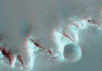
Whether or not we'll ever see a closeup view of Explorer from ground, we always have the HiRISE imagery. I don't remember seeing anaglyphs of the southern bays and Exp, so I made one myself. (In full res, using PSP_001414_ and 009141_1780)
I have an impression that the bay nearest to Exp is already in the process of eating into the little crater, and thus its present west rim is not anymore the 'original' one, as revealed by its inward deviation and slight dip from the otherwise nicely symmetrical rim. Also see the unusually sharp edge of the tip of the cape next to (left of) Explorer.
Attached thumbnail(s)
|
|
|
|
|
|
|
Oct 15 2008, 07:33 PM
Post
#195
|
|
 The Poet Dude Group: Moderator Posts: 5551 Joined: 15-March 04 From: Kendal, Cumbria, UK Member No.: 60 |
-------------------- |
|
|
|
|

|
Lo-Fi Version | Time is now: 27th April 2024 - 07:12 AM |
|
RULES AND GUIDELINES Please read the Forum Rules and Guidelines before posting. IMAGE COPYRIGHT |
OPINIONS AND MODERATION Opinions expressed on UnmannedSpaceflight.com are those of the individual posters and do not necessarily reflect the opinions of UnmannedSpaceflight.com or The Planetary Society. The all-volunteer UnmannedSpaceflight.com moderation team is wholly independent of The Planetary Society. The Planetary Society has no influence over decisions made by the UnmannedSpaceflight.com moderators. |
SUPPORT THE FORUM Unmannedspaceflight.com is funded by the Planetary Society. Please consider supporting our work and many other projects by donating to the Society or becoming a member. |
|