Endeavour Drive - Drivability analysis |

  |
Endeavour Drive - Drivability analysis |
 Oct 19 2008, 04:31 AM Oct 19 2008, 04:31 AM
Post
#616
|
||
 Senior Member  Group: Moderator Posts: 2785 Joined: 10-November 06 From: Pasadena, CA Member No.: 1345 |
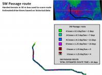
The estimated drive time (= score) for the SW Passage Route is 44 days.
This is about the same as the estimated time for the SW direct route, but it traverses much less violet terrain. It crosses mostly Blue terrain. Again the small patch of red on pavement terrain is probably overestimated. Due to Oppy's current position, this entry point is probably the easiest to access (might save a day). This is my favorite route so far. -Mike -------------------- Some higher resolution images available at my photostream: http://www.flickr.com/photos/31678681@N07/
|
|
 |
 
|
|
|
Oct 19 2008, 04:59 AM
Post
#617
|
|
 Senior Member Group: Members Posts: 1229 Joined: 24-December 05 From: The blue one in between the yellow and red ones. Member No.: 618 |
And I'm likin' it a lot, JM.
 But I could use some reassurance regarding that nasty splotch of red on the southerly leg. (Looks malignant.) Are we able to focus in on that stretch at a higher resolution - say 5 meter, or even 2 meter blocks - to see if it's as perilous as it looks? Finally, can you detail the procedure for inputting (golf term) the scientists' points of interest? TIA 
-------------------- My Grandpa goes to Mars every day and all I get are these lousy T-shirts!
|
|
|
|
|
Oct 19 2008, 05:25 AM
Post
#618
|
|||
|
Senior Member Group: Moderator Posts: 2785 Joined: 10-November 06 From: Pasadena, CA Member No.: 1345 |
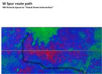
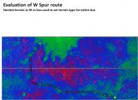
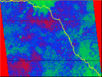
The W Spur route from Victoria Crater apron through the debris field to the fast green route intersection.
Black boxes are 50 m square:
Taking the most difficult terrain in the 50 m box to be the terrain type of the entire box (worst case scenario), here is the box-by-box terrain evaluation for the SW Passage route:
-------------------- Some higher resolution images available at my photostream: http://www.flickr.com/photos/31678681@N07/
|
||
|
|
|
||
|
Oct 19 2008, 05:29 AM
Post
#619
|
||
|
Senior Member Group: Moderator Posts: 2785 Joined: 10-November 06 From: Pasadena, CA Member No.: 1345 |
The estimated drive time (= score) for the SW Passage Route is a whopping 59 days.
There is a funky dark pattern with a brighter ring in the HiRise image near the bright green area. I'm flagging this as a potential Erebus-style dust trap. But the terrain surrounding this is pretty flat (aqua or blue) and going around this area shouldn't add to the drive time. (There are a few of these S of the indicated path where the path bends to the E. The proposed path avoids these by a wide margin.) -Mike -------------------- Some higher resolution images available at my photostream: http://www.flickr.com/photos/31678681@N07/
|
|
|
|
|
|
|
Oct 19 2008, 06:04 AM
Post
#620
|
||
|
Senior Member Group: Moderator Posts: 2785 Joined: 10-November 06 From: Pasadena, CA Member No.: 1345 |
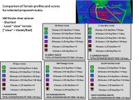
QUOTE (Shaka @ Oct 19 2008, 12:59 AM)  But I could use some reassurance regarding that nasty splotch of red on the southerly leg. (Looks malignant.) Are we able to focus in on that stretch at a higher resolution - say 5 meter, or even 2 meter blocks - to see if it's as perilous as it looks? Finally, can you detail the procedure for inputting (golf term) the scientists' points of interest? Yup! I'll put together some more detailed stuff covering the SW Passage. (The proposed routes do not take into account any scientific targets (are there any at this point?), but the SW passage does just pass to the S of the 50 m diameter "cute" crater.) Here's a comparison chart showing selected Victoria apron escape routes, with estimated times and terrain profiles for each of the routes:
-Mike -------------------- Some higher resolution images available at my photostream: http://www.flickr.com/photos/31678681@N07/
|
|
|
|
|
|
|
Oct 19 2008, 09:06 AM
Post
#621
|
|
|
Senior Member Group: Members Posts: 2922 Joined: 14-February 06 From: Very close to the Pyrénées Mountains (France) Member No.: 682 |
Mike, your work is just (sorry no enough good words come to mind).
Anyway, I just want to make sure here that you're aware that, apparently, the treck has started  
-------------------- |
|
|
|
|
Oct 19 2008, 09:46 PM
Post
#622
|
|
|
Member Group: Members Posts: 139 Joined: 14-October 05 From: Toronto, Canada Member No.: 529 |
My money is on the SW route.
It has the least amount of potentially dangerous stuff and the southerly leg gives us the half-pipes/pavement to drive between the bigger ripples. -------------------- -- Robin
|
|
|
|
|
Oct 19 2008, 09:55 PM
Post
#623
|
|
 Senior Member Group: Moderator Posts: 3431 Joined: 11-August 04 From: USA Member No.: 98 |
QUOTE (Zeke4ther @ Oct 19 2008, 02:46 PM) My money is on the SW route. Funny you mention it. The current drive direction mosaic is SW. Anyway will be fun to see what happens... |
|
|
|
|
Oct 19 2008, 10:30 PM
Post
#624
|
||
 Member Group: Members Posts: 236 Joined: 5-June 08 From: Udon Thani Member No.: 4185 |
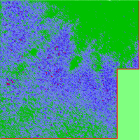
STDEV analyzes of area south of victoria for southerly driving direction, analyzes was carried out at 1 mtr resolution, red spots showing potentially dangerous areas.
|
|
|
|
|
|
|
Oct 19 2008, 10:33 PM
Post
#625
|
||
|
Member Group: Members Posts: 236 Joined: 5-June 08 From: Udon Thani Member No.: 4185 |
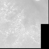
Unprocessed image of same area as above for comparison
|
|
|
|
|
|
|
Oct 19 2008, 11:36 PM
Post
#626
|
||
|
Member Group: Members Posts: 236 Joined: 5-June 08 From: Udon Thani Member No.: 4185 |
HighRes STDEV analyzes of area SW of Victoria crater for SW driving direction, red areas state potentially dangerous places
|
|
|
|
|
|
|
Oct 19 2008, 11:42 PM
Post
#627
|
||
|
Member Group: Members Posts: 236 Joined: 5-June 08 From: Udon Thani Member No.: 4185 |
Unprocessed image of above for comparison, had to reduce scale slightly to fit within attachments limits
|
|
|
|
|
|
|
Oct 20 2008, 12:32 AM
Post
#628
|
||
 Member Group: Members Posts: 257 Joined: 18-December 04 Member No.: 123 |
Figured I'd have a go at implementing a route finding algorithm. The one I had mentioned earlier, A*.
Basically I took Juramike's red/blue/green map. (Thanks a million for your efforts by the way, amazing) Broke it down into a grid with each grid square being X pixels wide/high. For each grid location I average the pixels it contains and get the RGB value. I break this down into the individual colour values: R = 'Bad' terrain B = 'Medium' terrain G = 'Good' terrain Then each grid is given a score based on these values, using a function I came up with from playing around. It's completely and utterly made up. So the score/cost of travelling through a grid location is: CODE (((3*bad)-good)*((2*Medium)-good) - (good^2) The route I have in the image here has grid squares of 5x5 pixels and took about 1 minute to generate on my 1.4Ghz Pentium M Processor with 500MB RAM so it's not too bad. The route shown is from the Top Left to the Bottom Right, just for illustration purposes. If anyone has a good way of using the R,G,B values like above then let me know and I'll plug it in! Edit: Seems I have a few bugs. God only knows how I got the route below from the code I just spotted.
Attached thumbnail(s)
-------------------- Turn the middle side topwise....TOPWISE!!
|
|
|
|
|
|
|
Oct 20 2008, 01:02 AM
Post
#629
|
|
|
Senior Member Group: Moderator Posts: 2785 Joined: 10-November 06 From: Pasadena, CA Member No.: 1345 |
QUOTE (jaredGalen @ Oct 19 2008, 08:32 PM) Edit: Seems I have a few bugs. God only knows how I got the route below from the code I just spotted. Wow! Really nice. I'm going to guess that your algorithm is trying to find a short path from the origin (0,0) which must be at upper left, to the largest X,Y which must be at lower right. -Mike -------------------- Some higher resolution images available at my photostream: http://www.flickr.com/photos/31678681@N07/
|
|
|
|
|
Oct 20 2008, 01:10 AM
Post
#630
|
|
|
Member Group: Members Posts: 257 Joined: 18-December 04 Member No.: 123 |
QUOTE (Juramike @ Oct 20 2008, 02:02 AM) I'm going to guess that your algorithm is trying to find a short path from the origin (0,0) which must be at upper left, to the largest X,Y which must be at lower right. -Mike Yep, forgot to mention that point about the origin. It seems the code is kinda doing what I thought after all so it's not too bad. When it comes to balancing distance and traversability I'm not sure how it works out. I'll try at some stage to do something like you have to look at the type of terrain per step and see what the overall count is like. Not tonight though.
-------------------- Turn the middle side topwise....TOPWISE!!
|
|
|
|
|

|
Lo-Fi Version | Time is now: 31st May 2024 - 04:02 PM |
|
RULES AND GUIDELINES Please read the Forum Rules and Guidelines before posting. IMAGE COPYRIGHT |
OPINIONS AND MODERATION Opinions expressed on UnmannedSpaceflight.com are those of the individual posters and do not necessarily reflect the opinions of UnmannedSpaceflight.com or The Planetary Society. The all-volunteer UnmannedSpaceflight.com moderation team is wholly independent of The Planetary Society. The Planetary Society has no influence over decisions made by the UnmannedSpaceflight.com moderators. |
SUPPORT THE FORUM Unmannedspaceflight.com is funded by the Planetary Society. Please consider supporting our work and many other projects by donating to the Society or becoming a member. |
|