Goodbye Victoria, The long trek has started |

  |
Goodbye Victoria, The long trek has started |
 Oct 28 2008, 07:15 PM Oct 28 2008, 07:15 PM
Post
#91
|
|
|
Senior Member  Group: Members Posts: 2921 Joined: 14-February 06 From: Very close to the Pyrénées Mountains (France) Member No.: 682 |
QUOTE (Tesheiner @ Oct 28 2008, 06:33 PM)  We should call it "sailing direction", perhaps. Let's even call it the "Red Sea of Sand of Meridianii" -------------------- |
 |
 
|
|
Oct 28 2008, 08:54 PM
Post
#92
|
||
|
Solar System Cartographer Group: Members Posts: 10166 Joined: 5-April 05 From: Canada Member No.: 227 |
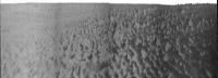
This is the horizon part of Ant103's panorama of the drive direction, with a bit of vertical stretching. A factor of ten. It shows that smooth patch off to the left - east - and the bigger drifts ahead and to the right. Looks like the outcrop area is slightly elevated. This doesn't really look ideal to me. I think the immediate drive might be in this direction, but I would expect a turn to the west in a while to head towards that smoother route.
Phil
-------------------- ... because the Solar System ain't gonna map itself.
Also to be found posting similar content on https://mastodon.social/@PhilStooke Maps for download (free PD: https://upload.wikimedia.org/wikipedia/comm...Cartography.pdf NOTE: everything created by me which I post on UMSF is considered to be in the public domain (NOT CC, public domain) |
|
|
|
|
|
|
Oct 28 2008, 09:20 PM
Post
#93
|
|
|
Senior Member Group: Moderator Posts: 4279 Joined: 19-April 05 From: .br at .es Member No.: 253 |
Good work Ant & Phil!
> I think the immediate drive might be in this direction, but I would expect a turn to the west in a while to head towards that smoother route. To the west or to the left - east?  I'm a bit puzzled by the current choice of route. There're smooth areas both to the west (W spur) and to the east (SW corridor) of the current position but everything, including today's planned post-drive images, indicates they are heading right to this big patch of bedrock due south. |
|
|
|
|
Oct 28 2008, 09:44 PM
Post
#94
|
|
|
Solar System Cartographer Group: Members Posts: 10166 Joined: 5-April 05 From: Canada Member No.: 227 |
Either direction might work but I intended to say what I did say - right - or west, as I indicated on a map in the other thread.
Phil -------------------- ... because the Solar System ain't gonna map itself.
Also to be found posting similar content on https://mastodon.social/@PhilStooke Maps for download (free PD: https://upload.wikimedia.org/wikipedia/comm...Cartography.pdf NOTE: everything created by me which I post on UMSF is considered to be in the public domain (NOT CC, public domain) |
|
|
|
|
Oct 28 2008, 10:31 PM
Post
#95
|
|
|
Member Group: Members Posts: 507 Joined: 10-September 08 Member No.: 4338 |
QUOTE (Tesheiner @ Oct 28 2008, 01:20 PM) Good work Ant & Phil! > I think the immediate drive might be in this direction, but I would expect a turn to the west in a while to head towards that smoother route. To the west or to the left - east? I'm a bit puzzled by the current choice of route. There're smooth areas both to the west (W spur) and to the east (SW corridor) of the current position but everything, including today's planned post-drive images, indicates they are heading right to this big patch of bedrock due south. http://planetary.org/blog/ Quote: "Opportunity was headed for an area where the north-south dunes of Meridiani Planum were spread thinly over exposed bedrock, a landscape that would provide Opportunity with a "highway" southward on its journey toward Endeavour crater." |
|
|
|
|
Oct 28 2008, 10:39 PM
Post
#96
|
|
 Administrator Group: Admin Posts: 5172 Joined: 4-August 05 From: Pasadena, CA, USA, Earth Member No.: 454 |
Don't read more into my update than is there -- that's no more than a summary of what appears to be the consensus view on this forum! You guys are my best "source" for MER news, as you all follow it much more closely than I do. I think we all agree that the direction of Opportunity's drive is taking it toward more driveable terrain -- the debates here are about exactly which direction it's headed.
I'm sure there will be more informed detail forthcoming this weekend when Salley will post her usual update. --Emily -------------------- My website - My Patreon - @elakdawalla on Twitter - Please support unmannedspaceflight.com by donating here.
|
|
|
|
|
Oct 28 2008, 10:58 PM
Post
#97
|
|
 Special Cookie Group: Members Posts: 2168 Joined: 6-April 05 From: Sintra | Portugal Member No.: 228 |
QUOTE (Tesheiner @ Oct 28 2008, 09:20 PM) I'm a bit puzzled by the current choice of route. There're smooth areas both to the west (W spur) and to the east (SW corridor) of the current position but everything, including today's planned post-drive images, indicates they are heading right to this big patch of bedrock due south. Why should you be puzzled when, apparently, the rover is heading towards bedrock? doesn't that mean safer drives? At least that was what I had in mind when marking my path, aiming whenever possible to patches of solid ground and not smooth dunes...but hey...what do I know?...  -------------------- "Ride, boldly ride," The shade replied, "If you seek for Eldorado!"
Edgar Alan Poe |
|
|
|
|
Oct 28 2008, 11:14 PM
Post
#98
|
|
|
Solar System Cartographer Group: Members Posts: 10166 Joined: 5-April 05 From: Canada Member No.: 227 |
Unfortunately, in this area the bedrock outcrops have the largest drifts scattered across them. So they are not a 'highway' as they were near Erebus.
Phil -------------------- ... because the Solar System ain't gonna map itself.
Also to be found posting similar content on https://mastodon.social/@PhilStooke Maps for download (free PD: https://upload.wikimedia.org/wikipedia/comm...Cartography.pdf NOTE: everything created by me which I post on UMSF is considered to be in the public domain (NOT CC, public domain) |
|
|
|
|
Oct 29 2008, 01:45 AM
Post
#99
|
|
|
Member Group: Members Posts: 813 Joined: 29-December 05 From: NE Oh, USA Member No.: 627 |
Thinking the same thing, Phil... look like big dunes wandering the bedrock road ahead... we shall see .....
Looking at those sand sea vistas... I think of Arthur C. Clarke's "The Sands of Mars"... wouldn't we all love to be trotting along there in person... listening to the lonely whistle of wind.... Craig |
|
|
|
|
Oct 29 2008, 01:50 AM
Post
#100
|
|
 Senior Member Group: Moderator Posts: 2785 Joined: 10-November 06 From: Pasadena, CA Member No.: 1345 |
QUOTE (belleraphon1 @ Oct 28 2008, 08:45 PM) .. listening to the lonely whistle of wind.... I can't quite yet imagine what the wind would sound like...  -------------------- Some higher resolution images available at my photostream: http://www.flickr.com/photos/31678681@N07/
|
|
|
|
|
Oct 29 2008, 01:54 AM
Post
#101
|
|
|
Member Group: Members Posts: 530 Joined: 21-March 06 From: Canada Member No.: 721 |
QUOTE (Phil Stooke @ Oct 28 2008, 06:14 PM) Unfortunately, in this area the bedrock outcrops have the largest drifts scattered across them. So they are not a 'highway' as they were near Erebus. Come on, Phil we're Canadians. That describes our highways perfectly.  |
|
|
|
|
Oct 29 2008, 01:55 AM
Post
#102
|
|
 The Insider Group: Members Posts: 669 Joined: 3-May 04 Member No.: 73 |
I think it's a great strategy having a sure footing of bedrock under the wheels and drive around the dunes. There is much less slippage and, with the availability of HiRISE maps, the route can be planned for longer distance ahead more accurately.
|
|
|
|
|
Oct 29 2008, 05:47 AM
Post
#103
|
|
|
Senior Member Group: Moderator Posts: 4279 Joined: 19-April 05 From: .br at .es Member No.: 253 |
QUOTE (Phil Stooke @ Oct 28 2008, 10:44 PM) Either direction might work but I intended to say what I did say - right - or west, as I indicated on a map in the other thread. Understood. I got confused by your reference to the smooth terrain at the left on your Phil-o-vision. QUOTE (Phil Stooke @ Oct 29 2008, 12:14 AM) Unfortunately, in this area the bedrock outcrops have the largest drifts scattered across them. So they are not a 'highway' as they were near Erebus. That's my point too. However I hope we will see some clever usage of autonomous driving technics. I'll use this same post to say that the drive planned for sol 1693 was executed and Opportunity moved another 110m due south. Expect bigger dunes right ahead. 
|
|
|
|
|
Oct 29 2008, 07:46 AM
Post
#104
|
|
|
Special Cookie Group: Members Posts: 2168 Joined: 6-April 05 From: Sintra | Portugal Member No.: 228 |
QUOTE (Pando @ Oct 29 2008, 01:55 AM) I think it's a great strategy having a sure footing of bedrock under the wheels and drive around the dunes. There is much less slippage and, with the availability of HiRISE maps, the route can be planned for longer distance ahead more accurately. Pando, my friend! Who would say we would be discussing this after all this years?...  Those are exactly my thoughts, even if we recall that near Jammerbugt we had some bedrock too, I believe that solid ground + HiRISE maps + new software are, in my humble special cookie opinion, the best option for Opportunity in the current scenario. Tesheiner, I'm curious to see your updated map... 
-------------------- "Ride, boldly ride," The shade replied, "If you seek for Eldorado!"
Edgar Alan Poe |
|
|
|
|
Oct 29 2008, 07:54 AM
Post
#105
|
|
 Member Group: Members Posts: 568 Joined: 20-April 05 From: Silesia Member No.: 299 |
QUOTE (Tesheiner @ Oct 29 2008, 06:47 AM) Expect bigger dunes right ahead. 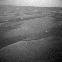 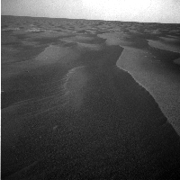 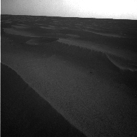
-------------------- Free software for planetary science (including Cassini Image Viewer).
http://members.tripod.com/petermasek/marinerall.html |
|
|
|
|

|
Lo-Fi Version | Time is now: 23rd May 2024 - 01:34 PM |
|
RULES AND GUIDELINES Please read the Forum Rules and Guidelines before posting. IMAGE COPYRIGHT |
OPINIONS AND MODERATION Opinions expressed on UnmannedSpaceflight.com are those of the individual posters and do not necessarily reflect the opinions of UnmannedSpaceflight.com or The Planetary Society. The all-volunteer UnmannedSpaceflight.com moderation team is wholly independent of The Planetary Society. The Planetary Society has no influence over decisions made by the UnmannedSpaceflight.com moderators. |
SUPPORT THE FORUM Unmannedspaceflight.com is funded by the Planetary Society. Please consider supporting our work and many other projects by donating to the Society or becoming a member. |
|