Goodbye Victoria, The long trek has started |

  |
Goodbye Victoria, The long trek has started |
 Nov 5 2008, 11:26 PM Nov 5 2008, 11:26 PM
Post
#151
|
|
 Member  Group: Members Posts: 524 Joined: 24-November 04 From: Heraklion, GR. Member No.: 112 |
So nice to have you back !

|
 |
 
|
|
Nov 5 2008, 11:32 PM
Post
#152
|
|
 Senior Member Group: Members Posts: 1229 Joined: 24-December 05 From: The blue one in between the yellow and red ones. Member No.: 618 |
Ciao, Paolo! Come vai?
 Very glad to hear from you again! Every time Oppy makes a turn, we're thinking, What is Paolo up to now? I am so very pleased to know that sometimes we will be finding out in the future. You cannot imagine how much that magnifies our enjoyment of the MER adventure. -------------------- My Grandpa goes to Mars every day and all I get are these lousy T-shirts!
|
|
|
|
|
Nov 5 2008, 11:39 PM
Post
#153
|
|
 Senior Member Group: Members Posts: 4247 Joined: 17-January 05 Member No.: 152 |
QUOTE (RoverDriver @ Nov 6 2008, 12:15 AM)  Tap, tap. Is this thing on? We hear you loud and clear, Paolo! I echo the last comments completely. It is so good to learn something of what's behind the images we see, instead of just guessing like we often do here! Are you able to enlighten us at all on what's behind the current choice of route? Science/cobbles, easier autonav, easier driving,...? |
|
|
|
|
Nov 6 2008, 12:07 AM
Post
#154
|
|
|
Member Group: Admin Posts: 976 Joined: 29-September 06 From: Pasadena, CA - USA Member No.: 1200 |
QUOTE (fredk @ Nov 5 2008, 03:39 PM) We hear you loud and clear, Paolo! I echo the last comments completely. It is so good to learn something of what's behind the images we see, instead of just guessing like we often do here! Are you able to enlighten us at all on what's behind the current choice of route? Science/cobbles, easier autonav, easier driving,...? The route we are following should minimize encounter with Purgatoids. It will be considerably longer than a direct route but should be safer and maximize science return. As for what I have been doing recently: for the past few weeks I have been busy on the other side of the planet trying to push a rover up a slope. Paolo -------------------- Disclaimer: all opinions, ideas and information included here are my own,and should not be intended to represent opinion or policy of my employer.
|
|
|
|
|
Nov 6 2008, 04:07 AM
Post
#155
|
|
 Senior Member Group: Moderator Posts: 3431 Joined: 11-August 04 From: USA Member No.: 98 |
Nice to see you back, Paolo. We'll take what bits of information we can get and not ask too much. So many questions come up along the way.
 |
|
|
|
|
Nov 6 2008, 10:50 AM
Post
#156
|
|
|
Forum Contributor Group: Members Posts: 1372 Joined: 8-February 04 From: North East Florida, USA. Member No.: 11 |
They don't build rovers so the wheels drop off after 601 m.......
|
|
|
|
|
Nov 6 2008, 03:37 PM
Post
#157
|
|
|
Member Group: Members Posts: 713 Joined: 30-March 05 Member No.: 223 |
This is great to have you back on the forum, Rover Driver !
|
|
|
|
|
Nov 6 2008, 07:12 PM
Post
#158
|
|||
|
Senior Member Group: Members Posts: 4247 Joined: 17-January 05 Member No.: 152 |
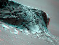
As we say farewell to Victoria, here are a couple of long baseline stereo views of its cliffs, first from sols 1668/70 and second from sols 1682/83 showing Cape Victory:
It will be a long time before we have views this spectacular from Oppy again... |
||
|
|
|
||
|
Nov 6 2008, 07:22 PM
Post
#159
|
|
 Junior Member Group: Members Posts: 39 Joined: 5-June 06 Member No.: 803 |
QUOTE (Nirgal @ Nov 6 2008, 11:37 AM) This is great to have you back on the forum, Rover Driver ! Seconded! (or is it thirded!). I've been following UMSF since soon after the landings, but rarely post. One thing I've been wondering about: What sensors are available for autonav? I ask because a lot of the time in the march to and from Victoria, it looked to me like a 'follow the trough' algorithm would have been useful. Oppy seems to spend a lot more time trying to go between ridges rather than cross them. I'm under the strong impression (if I'm wrong, just stop reading) that the MERs have tiltmeters. An algorithm which said, in effect, 'As long as wheel slip is low, steer gently towards whichever front wheel is downhill' would allow Oppy to track along a trough. just another back seat driver..... ce |
|
|
|
| Guest_PhilCo126_* |
Nov 7 2008, 10:04 AM
Post
#160
|
|
Guests |
Just explaining an odd term for non-native English speakers: Purgatoids = larger ripples (dangerous dunes in fact)

|
|
|
|
|
Nov 7 2008, 02:11 PM
Post
#161
|
|
|
Senior Member Group: Moderator Posts: 3431 Joined: 11-August 04 From: USA Member No.: 98 |
QUOTE (PhilCo126 @ Nov 7 2008, 04:04 AM) Just explaining an odd term for non-native English speakers: Purgatoids = larger ripples (dangerous dunes in fact) For any newbies, we should add that it's not just an 'English-ism', but rather a Mars Exploration Rover-specific term. Purgatoids are drifts that look like 'Purgatory', where Opportunity famously got stuck for a long time. |
|
|
|
|
Nov 7 2008, 06:56 PM
Post
#162
|
|
|
Member Group: Members Posts: 293 Joined: 22-September 08 From: Spain Member No.: 4350 |
Purgatoids from Mars -- I would buy that if it was a pulp sci-fi book.
|
|
|
|
|
Nov 7 2008, 07:20 PM
Post
#163
|
|
|
Junior Member Group: Members Posts: 45 Joined: 25-March 05 Member No.: 216 |
QUOTE (Fran Ontanaya @ Nov 7 2008, 11:56 AM) Purgatoids from Mars -- I would buy that if it was a pulp sci-fi book. Purgatoids - an irritation that can be diminished with some 'Preparation P' -------------------- My Open Office Website: http://www.openofficetips.com
|
|
|
|
|
Nov 7 2008, 08:24 PM
Post
#164
|
|
|
Member Group: Admin Posts: 976 Joined: 29-September 06 From: Pasadena, CA - USA Member No.: 1200 |
QUOTE (CryptoEngineer @ Nov 6 2008, 11:22 AM) Seconded! (or is it thirded!). I've been following UMSF since soon after the landings, but rarely post. One thing I've been wondering about: What sensors are available for autonav? I ask because a lot of the time in the march to and from Victoria, it looked to me like a 'follow the trough' algorithm would have been useful. Oppy seems to spend a lot more time trying to go between ridges rather than cross them. I'm under the strong impression (if I'm wrong, just stop reading) that the MERs have tiltmeters. An algorithm which said, in effect, 'As long as wheel slip is low, steer gently towards whichever front wheel is downhill' would allow Oppy to track along a trough. just another back seat driver..... ce This is an excellent question. When we talk about an "autonav" drive we intend a drive where cameras are used to observe the terrain around the vehicle and determine if there is a safe path or if the path specified is safe. This drive modality is pretty expensive (slower driving). You also mention "low slip". In order to measure slip, we need to use the cameras to measure the actual rover motion compared to the commanded motion (visual odometry). This is another CPU intensive task and it is used only when needed, either when we are on slopes or periodically on long drives (to verify we are still moving and not embedded in a ripple for example). The rovers also have accelerometers and gyros (what you called "tiltmeters") assembled in an IMU (inertial measurement unit) that allows to accurately measure roll, pitch and yaw (RPY) of the rover. If you are interested you can google around and you will find which make/model and its specs. This sensor is turned on every time we drive and constantly provides the rover with the RPY, the rover "attitude". This information is important not only for driving but for communication (where to point the antenna) and cameras and MTES on the PMA. While traversing the big ripples from Purgatory down to Victoria Anulus we used the IMU to specify safe limits on RPY but never used roll and/or pitch measurements to dynamically alter the rover's path. We have begun using RPY measurements to dynamically adapt the rover's path on both rovers only recently. We also have sensors that report the configuration of the suspension system (rockers/bogies) and recently we used these measurements as well to dynamically modify the path or behaviour of the rover. While it is relatively easy to come up with a strategy to drive between ripple crests, it is very difficult to ensure the vehicle will recognize an unsafe condition and stop. These new "smart" sequences quickly become very complex and difficult to prove safe in all conditions. Paolo -------------------- Disclaimer: all opinions, ideas and information included here are my own,and should not be intended to represent opinion or policy of my employer.
|
|
|
|
|
Nov 7 2008, 11:36 PM
Post
#165
|
|
 Member Group: Members Posts: 646 Joined: 23-December 05 From: Forest of Dean Member No.: 617 |
QUOTE (fredk @ Nov 6 2008, 08:12 PM) It will be a long time before we have views this spectacular from Oppy again... "We will not see the like of those days again." I learned a new word from the kids at work this week - "facepalm" - I'm still not absolutely certain what it means, but I can picture many geologically aware readers doing one in a moment's time, so apologies if this is a silly question. There seem to be quite a few protuding nodule-like features on Cape Victory evident in fredk's analglyph, including one right in the middle that looks almost like a freeze-frame of a cannon-ball smacking into a castle wall a few hundred years ago. Why might the slightly harder rock which erodes out in this way take a shape that crosses many vertical layers? And why might it be different from Duck Bay? Is there a terrestrial analogue? -------------------- --
Viva software libre! |
|
|
|
|

|
Lo-Fi Version | Time is now: 28th May 2024 - 12:23 PM |
|
RULES AND GUIDELINES Please read the Forum Rules and Guidelines before posting. IMAGE COPYRIGHT |
OPINIONS AND MODERATION Opinions expressed on UnmannedSpaceflight.com are those of the individual posters and do not necessarily reflect the opinions of UnmannedSpaceflight.com or The Planetary Society. The all-volunteer UnmannedSpaceflight.com moderation team is wholly independent of The Planetary Society. The Planetary Society has no influence over decisions made by the UnmannedSpaceflight.com moderators. |
SUPPORT THE FORUM Unmannedspaceflight.com is funded by the Planetary Society. Please consider supporting our work and many other projects by donating to the Society or becoming a member. |
|