Endeavour Drive - Drivability analysis |

  |
Endeavour Drive - Drivability analysis |
 Dec 5 2008, 11:12 AM Dec 5 2008, 11:12 AM
Post
#736
|
|
 Member  Group: Members Posts: 255 Joined: 4-January 05 Member No.: 135 |
This might be interesting to some of the more mathematically minded people here, and
might be useful for the kind of processing you are looking at. Mathematica image processing Very cool stuff... Chris |
 |
 
|
| Guest_Oersted_* |
Dec 8 2008, 12:08 AM
Post
#737
|
|
Guests |
I read about that too Chris, definitely worth a look!
|
|
|
|
|
Dec 8 2008, 11:32 PM
Post
#738
|
|
 Senior Member Group: Moderator Posts: 2785 Joined: 10-November 06 From: Pasadena, CA Member No.: 1345 |
Here's another interesting article:
Helmick et al IEEEAC paper #1668. "Terrain Adaptive Navigation for Mars Rovers". (Freely available here) -Mike -------------------- Some higher resolution images available at my photostream: http://www.flickr.com/photos/31678681@N07/
|
|
|
|
|
Dec 9 2008, 04:04 AM
Post
#739
|
||
|
Senior Member Group: Moderator Posts: 2785 Joined: 10-November 06 From: Pasadena, CA Member No.: 1345 |
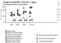
Scorecard for Sol 1711++:
For the UMSF Terrain Models, here are 10 m x 10 m normalized grayscale pixel averages for Oppy's 1711 position: HiRise (raw): 149.77 HiRise (normalized): 246.86 Malaska 20081003 normalized grayscale Terrain Model: 174.02 Canvin 20081001 normalized grayscale Terrain Model: 165.23 Ontanaya 20081001 normalized grayscale Terrain Model: 150.26 Butler 20081006 normalized grayscale Terrain Model: 163.21 Sassen 20081031 normalized grayscale Terrain Model: 97.2 -Mike -------------------- Some higher resolution images available at my photostream: http://www.flickr.com/photos/31678681@N07/
|
|
|
|
|
|
|
Dec 9 2008, 05:47 AM
Post
#740
|
||
|
Senior Member Group: Moderator Posts: 2785 Joined: 10-November 06 From: Pasadena, CA Member No.: 1345 |
Here's a graph of the "observables" for the Sol 1707-1711 (and counting...) track:
(compare with previous graph here)
There does seem to be an empirical relationship between the normalized Canvin FT (orange dot), the HiRise value (brown dot) and the normalized HiRise value (red dot) and a loose correlation with the toe cleat (star pattern) impression. When the orange dot is far away from the red dot AND the brown dot is close to the red dot, then the cleat pattern is worse. But I'm way too brain dead after staring at this all evening to try to come up with a qualitative/quantitative relationship.... -------------------- Some higher resolution images available at my photostream: http://www.flickr.com/photos/31678681@N07/
|
|
|
|
|
|
|
Dec 10 2008, 05:02 AM
Post
#741
|
|||
|
Senior Member Group: Moderator Posts: 2785 Joined: 10-November 06 From: Pasadena, CA Member No.: 1345 |
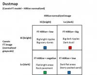
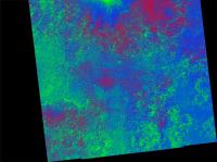
Here's an attempt at making a Dustmap of Meridiani.
I normalized and grayscaled James Canvin's FT model, then subtracted a normalized HiRise image and added a small offset. The idea is that the FT indicated waves (bright in FT model) would subtract nicely with dark features (dark windblown basaltic sand migrating from dust trap to dustrap across Meridiani):
Here is the GBR(dust) colorized result:
The bummer with this method is that big scary dunes are not differentiated much from easy parking lot terrain. They are both colorized blue. The cool part is that dust areas are indicated in red. A bonus cool part is that rock pavement (low FT - bright HiRise = neg) is indicated in black (colorized green). You can see the finger of green up by Victoria crater that almost coincides with Oppy's route. -Mike -------------------- Some higher resolution images available at my photostream: http://www.flickr.com/photos/31678681@N07/
|
||
|
|
|
||
|
Dec 11 2008, 01:02 AM
Post
#742
|
|
|
Senior Member Group: Moderator Posts: 2785 Joined: 10-November 06 From: Pasadena, CA Member No.: 1345 |
JPEGs of "Dustmap" Terrain model 20081210 available:
GBR colorized (max resolution option is 18 Mb): http://www.flickr.com/photos/31678681@N07/3097440938/ grayscale (max resolution option is 7 Mb): http://www.flickr.com/photos/31678681@N07/3096616731/ (The grayscale version has a nice effect of really indicating all the subtle craterforms in the area) -Mike -------------------- Some higher resolution images available at my photostream: http://www.flickr.com/photos/31678681@N07/
|
|
|
|
|
Dec 11 2008, 01:40 AM
Post
#743
|
||
|
Senior Member Group: Moderator Posts: 2785 Joined: 10-November 06 From: Pasadena, CA Member No.: 1345 |
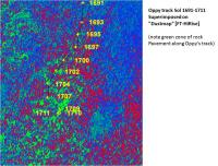
Zoom of Dustmap[FT-HiRise] Terrain Model with Oppy's track from Sol 1691-1711 superimposed:
The "green" rock pavement correlates with Oppy's track. -Mike -------------------- Some higher resolution images available at my photostream: http://www.flickr.com/photos/31678681@N07/
|
|
|
|
|
|
|
Dec 15 2008, 03:38 AM
Post
#744
|
|||
|
Senior Member Group: Moderator Posts: 2785 Joined: 10-November 06 From: Pasadena, CA Member No.: 1345 |
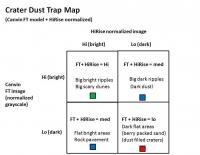
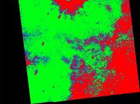
Another attempt at a different way of looking for dust traps. This time trying to isolate out Flat Dark filled craters: low value in FT model and low value in Normalized HiRise). Here's the rationale:
I used the sum of the normalized grayscale James Canvin FT Terrain model with the normalized HiRise image. After contrast enhancing and a few filtered blurs, the whole thing was inverted, then colorized. Here is the exact recipe; Sum (Photoshop "Apply Image"; scale = 1, offset = 0) normalized grayscale James Canvin FT Terrain model with normalized HiRise image Curve adjustment (0,0; 7,0; 109,40; 154, 120; 200, 240; 230,255) Filter/Noise/Median 2 pixels Curve adjustment (0,0; 7,0; 78, 26; 129, 115; 148, 151; 182, 215; 255, 255) Gaussian blur 1 pixel Invert image Colorize using the standard color table And the result:
The smaller bright red splots and circular dots are mostly filled craters. The much larger red regions are areas of low waves and dark sand. These could be "safe" blueberry armored flat terrain. -Mike -------------------- Some higher resolution images available at my photostream: http://www.flickr.com/photos/31678681@N07/
|
||
|
|
|
||
|
Dec 15 2008, 04:43 AM
Post
#745
|
||
|
Senior Member Group: Moderator Posts: 2785 Joined: 10-November 06 From: Pasadena, CA Member No.: 1345 |
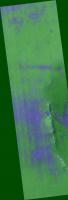
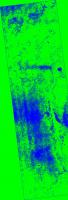
Zoom of Flat Dark dust trap Map Invert[FT+HiRise] Terrain Model with Oppy's track from Sol 1691-1711 superimposed:
(Note that Oppy's track Southward from Victoria has not come close to any of the potential flat dark dust traps. So Navcam images in this area can't be used to confirm if this terrain model has any value.) JPEGs of "Flat Dark Dust Trap" Terrain model 20081214 available at 2 m/pixel resolution (12.5% HiRise): GBR colorized (max resolution option is 6.3 Mb): http://flickr.com/photos/31678681@N07/3108...57610916194789/ grayscale (max resolution option is 2.5 Mb): http://flickr.com/photos/31678681@N07/3108...57610916194789/ -Mike -------------------- Some higher resolution images available at my photostream: http://www.flickr.com/photos/31678681@N07/
|
|
|
|
|
|
|
Dec 16 2008, 01:24 AM
Post
#746
|
|
|
Senior Member Group: Moderator Posts: 2785 Joined: 10-November 06 From: Pasadena, CA Member No.: 1345 |
In the southern section of the S Victoria Crater HiRise images, there are a series of large scale ripple patterns (26 m wavelength) that are going NNW. (So..crests are WSW to NNE)
I think these are dunes/dust that have moved more "recently" since they are in line with the current prevailing wind pattern. They might indicate a hazard area, or they might be nothing at all. I spent the last few days trying to "light them up" and indicate them in a model (using the differential shift of 15 E pixels and 50 S pixels) but haven't had much luck getting them away from the normal brightness variation. Any suggestions? -Mike -------------------- Some higher resolution images available at my photostream: http://www.flickr.com/photos/31678681@N07/
|
|
|
|
|
Dec 16 2008, 04:42 PM
Post
#747
|
|
|
Member Group: Admin Posts: 976 Joined: 29-September 06 From: Pasadena, CA - USA Member No.: 1200 |
QUOTE (Juramike @ Dec 15 2008, 05:24 PM)  In the southern section of the S Victoria Crater HiRise images, there are a series of large scale ripple patterns (26 m wavelength) that are going NNW. (So..crests are WSW to NNE) I think these are dunes/dust that have moved more "recently" since they are in line with the current prevailing wind pattern. They might indicate a hazard area, or they might be nothing at all. I spent the last few days trying to "light them up" and indicate them in a model (using the differential shift of 15 E pixels and 50 S pixels) but haven't had much luck getting them away from the normal brightness variation. Any suggestions? -Mike I cannot comment on the age of these ripples (in the sense that it is way above my head). If you are trying to find them, you could try using correlation with a template. Since they are axial symmetric, you could even try a 1D correlation with a Nx1 strip extracted from a manual selection. If you are unfamiliar with correletion, email me and I can give you a quick explanation (unless anyone eslse is interested and want me to post it). Paolo -------------------- Disclaimer: all opinions, ideas and information included here are my own,and should not be intended to represent opinion or policy of my employer.
|
|
|
|
|
Dec 16 2008, 07:22 PM
Post
#748
|
|
|
Senior Member Group: Moderator Posts: 2785 Joined: 10-November 06 From: Pasadena, CA Member No.: 1345 |
QUOTE (RoverDriver @ Dec 16 2008, 11:42 AM) If you are unfamiliar with correletion, email me and I can give you a quick explanation (unless anyone eslse is interested and want me to post it). I'm interested. Is this an easy step-by-step thing to do in Photoshop? -------------------- Some higher resolution images available at my photostream: http://www.flickr.com/photos/31678681@N07/
|
|
|
|
|
Dec 16 2008, 07:54 PM
Post
#749
|
|
|
Member Group: Admin Posts: 976 Joined: 29-September 06 From: Pasadena, CA - USA Member No.: 1200 |
QUOTE (Juramike @ Dec 16 2008, 11:22 AM) I'm interested. Is this an easy step-by-step thing to do in Photoshop? I don't use Photoshop so I can't comment on that. Correlation is well known machine visoin algorithm so it might be available in Photoshop. If not I can give you a quick explanation on what it means and you could try to implement it yourself. Paolo -------------------- Disclaimer: all opinions, ideas and information included here are my own,and should not be intended to represent opinion or policy of my employer.
|
|
|
|
|
Dec 18 2008, 04:38 PM
Post
#750
|
|||||
|
Newbie Group: Members Posts: 16 Joined: 24-September 08 Member No.: 4351 |
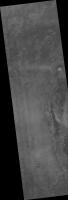
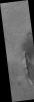
I have finally completed my analysis of the new Endeavor image. I used exactly the same parameters as for my Victoria analysis. Apparently the Victoria image was near the limits of a couple of the tools I used because the new image broke them. But I persevered and found different ways to get it into the processing tool (the actual analysis tool didn't have a problem with the size, although I think it was getting close!). And of course the outputs are larger as well. I did my 64x64 2dfft on every fifth pixel in each direction, and filled the result in all 25 pixels (even so it took 10 hours!). So I can decimate by 5x each way without losing any information at all. That png file is 5961x17628 pixels and 130MB, and I don't know how to post it. The jpgs are of postable size. So I further decimated by 4x each way, and now the files are small enough to be posted to speedyshare, as I did earlier. The links are here (jpgs are on 5x decimated from original, pngs are 20x):
blended image: http://www.speedyshare.com/714664859.html (image1a.png) http://www.speedyshare.com/793846195.html (image1.jpg) analysis only in RGB: http://www.speedyshare.com/725624573.html (image2a.png) http://www.speedyshare.com/714399661.html (image2.jpg) analysis only as grayscale: http://www.speedyshare.com/978793399.html (image3a.png) http://www.speedyshare.com/604469177.html (image3.jpg) original image at same scale: http://www.speedyshare.com/591706186.html (image4a.png) http://www.speedyshare.com/338648594.html (image4.jpg) I attach here some previews at yet another 2x decimation and conversion to jpg. I originally used a somewhat more optimistic choice of color scale than James did (which I stuck with for this one), and it makes the Endurance section look like a cakewalk, at least as far as ripples go. I also saw lots of 'Anatolia' features that could be a whole different kind of drivability hazard. Looking forward to the journey! If anyone wants the larger files and has a place for me to send them, just let me know! Bill Butler
Attached thumbnail(s)
|
||||
|
|
|
||||
|

|
Lo-Fi Version | Time is now: 23rd May 2024 - 09:06 PM |
|
RULES AND GUIDELINES Please read the Forum Rules and Guidelines before posting. IMAGE COPYRIGHT |
OPINIONS AND MODERATION Opinions expressed on UnmannedSpaceflight.com are those of the individual posters and do not necessarily reflect the opinions of UnmannedSpaceflight.com or The Planetary Society. The all-volunteer UnmannedSpaceflight.com moderation team is wholly independent of The Planetary Society. The Planetary Society has no influence over decisions made by the UnmannedSpaceflight.com moderators. |
SUPPORT THE FORUM Unmannedspaceflight.com is funded by the Planetary Society. Please consider supporting our work and many other projects by donating to the Society or becoming a member. |
|