Post Solar Conjunction/Santorini Study Drive, The second leg in our Journey to Endeavor Crater |

  |
Post Solar Conjunction/Santorini Study Drive, The second leg in our Journey to Endeavor Crater |
 Jan 27 2009, 07:20 PM Jan 27 2009, 07:20 PM
Post
#136
|
|
|
Founder  Group: Chairman Posts: 14432 Joined: 8-February 04 Member No.: 1 |
Reminds me, ever so slightly, of Anatolia back up in the Eagle-Endurance days.
|
 |
 
|
|
Jan 27 2009, 09:07 PM
Post
#137
|
|
|
Senior Member Group: Moderator Posts: 4279 Joined: 19-April 05 From: .br at .es Member No.: 253 |
I'm wondering if we will see different kinds of bedrock once back on flat terrain...
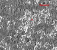
Speaking of feature names, "Surveyor" (crater?) is on the list of images planned for today, sol 1782. My guess: it's the tiny crater almost S of the current position which will be imaged on a "mid-drive" mosaic. 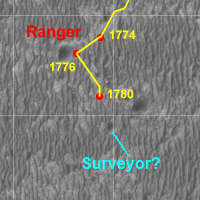
|
|
|
|
|
Jan 27 2009, 11:32 PM
Post
#138
|
|
|
Member Group: Admin Posts: 976 Joined: 29-September 06 From: Pasadena, CA - USA Member No.: 1200 |
That would be a good guess. The answer is in about 10 hours.
Paolo -------------------- Disclaimer: all opinions, ideas and information included here are my own,and should not be intended to represent opinion or policy of my employer.
|
|
|
|
|
Jan 28 2009, 02:24 PM
Post
#139
|
|
 Junior Member Group: Members Posts: 57 Joined: 17-May 06 From: Houston, Texas Member No.: 776 |
QUOTE (Tesheiner @ Jan 27 2009, 04:07 PM)  I'm wondering if we will see different kinds of bedrock once back on flat terrain... Speaking of feature names, "Surveyor" (crater?) is on the list of images planned for today, sol 1782. My guess: it's the tiny crater almost S of the current position which will be imaged on a "mid-drive" mosaic. I wonder if the three craters formed at the same time from meteor that broke into several pieces? They look similarly eroded. -------------------- |
|
|
|
|
Jan 28 2009, 04:10 PM
Post
#140
|
|
 Senior Member Group: Moderator Posts: 3431 Joined: 11-August 04 From: USA Member No.: 98 |
Now this is exciting. Looks like there was a pretty long drive to the south and west on sol 1782. And although I'm no judge of these things, it looks like the drifts are thinning out quite a bit!
Here's the Navcam mosaic (so far), I left it in full equirectangular facing south in case anyone wants to reprocess it. 
|
|
|
|
|
Jan 28 2009, 04:53 PM
Post
#141
|
|
 Senior Member Group: Moderator Posts: 2262 Joined: 9-February 04 From: Melbourne - Oz Member No.: 16 |
I think your right Mike. Looks like about 110m SSW
-------------------- |
|
|
|
|
Jan 28 2009, 04:56 PM
Post
#142
|
|||
|
Solar System Cartographer Group: Members Posts: 10170 Joined: 5-April 05 From: Canada Member No.: 227 |
Here it is.
Phil
-------------------- ... because the Solar System ain't gonna map itself.
Also to be found posting similar content on https://mastodon.social/@PhilStooke Maps for download (free PD: https://upload.wikimedia.org/wikipedia/comm...Cartography.pdf NOTE: everything created by me which I post on UMSF is considered to be in the public domain (NOT CC, public domain) |
||
|
|
|
||
|
Jan 28 2009, 05:13 PM
Post
#143
|
||
|
Senior Member Group: Moderator Posts: 2262 Joined: 9-February 04 From: Melbourne - Oz Member No.: 16 |
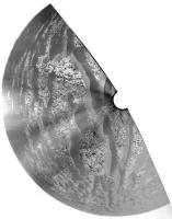
If you believe my ripple size mapping then we're through the roughest seas.
Green dot - approximate sol 1782 position -------------------- |
|
|
|
|
|
|
Jan 28 2009, 05:13 PM
Post
#144
|
|
|
Senior Member Group: Moderator Posts: 3431 Joined: 11-August 04 From: USA Member No.: 98 |
Look at that! Beautiful matchup.
|
|
|
|
|
Jan 28 2009, 08:31 PM
Post
#145
|
|
|
Senior Member Group: Moderator Posts: 4279 Joined: 19-April 05 From: .br at .es Member No.: 253 |
QUOTE (jamescanvin @ Jan 28 2009, 06:13 PM) If you believe my ripple size mapping then we're through the roughest seas. My impression is that we already crossed the worst of it. Still rough but less on each driving sol. |
|
|
|
|
Jan 28 2009, 09:38 PM
Post
#146
|
|
 Member Group: Members Posts: 444 Joined: 1-July 05 From: New York City Member No.: 424 |
Do you mean the worst of the whole drive, or merely of this segment?
TTT |
|
|
|
|
Jan 28 2009, 09:56 PM
Post
#147
|
||
 Senior Member Group: Members Posts: 4247 Joined: 17-January 05 Member No.: 152 |
Thanks for the location update on your ripple map, James. Looking at that map and Tesheiner's route map, I can see two options now. First, continue farther south, until we reach the smoother, blue region on the ripple map, then head east. The second option is to head east around now, following the patches of exposed bedrock, even though the ripples are somewhat higher here. I'll guess that they'll drive a few hundred metres farther south, then head east along the southernmost reaches of the current stretch of exposed bedrock.
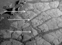
On another topic, has anyone else noticed the small raised ridges in the bedrock at the sol 1782 location:
Presumably old fissures that filled with a harder material. Does anyone remember seeing features like this before? |
|
|
|
|
|
|
Jan 28 2009, 10:00 PM
Post
#148
|
|
|
Senior Member Group: Moderator Posts: 3431 Joined: 11-August 04 From: USA Member No.: 98 |
QUOTE (fredk @ Jan 28 2009, 03:56 PM) Does anyone remember seeing features like this before? There were features like that Also the feature's placement way out here in the middle of nowhere might be interesting, although I don't know. |
|
|
|
|
Jan 28 2009, 10:26 PM
Post
#149
|
||
|
Senior Member Group: Moderator Posts: 2262 Joined: 9-February 04 From: Melbourne - Oz Member No.: 16 |
QUOTE (Tom Tamlyn @ Jan 28 2009, 09:38 PM) Do you mean the worst of the whole drive, or merely of this segment? Worst of the whole drive - depending on the route taken. Several kilometers of these slightly smaller ripples before heading out onto the 'parking lot' (like the terrain around Eagle/Endurance) a couple of km's before 'mini-Endurance'. Here is the whole route with a green dot for our approximate location.
A long way to go... -------------------- |
|
|
|
|
|
|
Jan 28 2009, 11:03 PM
Post
#150
|
|
 Senior Member Group: Members Posts: 2173 Joined: 28-December 04 From: Florida, USA Member No.: 132 |
QUOTE (RobertEB @ Jan 28 2009, 09:24 AM) I wonder if the three craters formed at the same time from meteor that broke into several pieces? They look similarly eroded. If, since their formation, at the same time or different times, the craters were filled in and covered and are just now being uncovered, the similar degree of uncovering would be no indication that they were formed at the same time. |
|
|
|
|

|
Lo-Fi Version | Time is now: 28th May 2024 - 04:13 PM |
|
RULES AND GUIDELINES Please read the Forum Rules and Guidelines before posting. IMAGE COPYRIGHT |
OPINIONS AND MODERATION Opinions expressed on UnmannedSpaceflight.com are those of the individual posters and do not necessarily reflect the opinions of UnmannedSpaceflight.com or The Planetary Society. The all-volunteer UnmannedSpaceflight.com moderation team is wholly independent of The Planetary Society. The Planetary Society has no influence over decisions made by the UnmannedSpaceflight.com moderators. |
SUPPORT THE FORUM Unmannedspaceflight.com is funded by the Planetary Society. Please consider supporting our work and many other projects by donating to the Society or becoming a member. |
|