Post Solar Conjunction/Santorini Study Drive, The second leg in our Journey to Endeavor Crater |

  |
Post Solar Conjunction/Santorini Study Drive, The second leg in our Journey to Endeavor Crater |
 Feb 2 2009, 03:41 PM Feb 2 2009, 03:41 PM
Post
#196
|
|
|
Founder  Group: Chairman Posts: 14432 Joined: 8-February 04 Member No.: 1 |
Imagine prevailing winds for 2,000,000,000 years. Little ridges and furrows in the rock are going to affect the flow of the wind over the ground, causing little disturbances like that I would have thought. The opposite of a wind-tail behind a rock.
Just thinking - perhaps an IDD keep-out volume violation occurred to end the drive early - the bottom of the IDD turret, and the 'end' (nearest to WEB) of the Mossbauer seems quite close to the dune ahead. I'm assuming auto-nav FHAZ pairs are used to establish if the IDD is about to bash into something. What's good is that whilst the wheels are sinking in a bit to these dunes ( see the RHAZ) - I don't think there's much wheel slippage going on - the cleat marks are neat and evenly spaced. |
 |
 
|
|
Feb 2 2009, 05:23 PM
Post
#197
|
||
 Senior Member Group: Moderator Posts: 2785 Joined: 10-November 06 From: Pasadena, CA Member No.: 1345 |
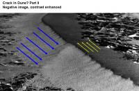
I was wondering what it would look like if the ground shifted/displaced AFTER dune emplacement.
(The N-S big dunes are remnants from an earlier wind regime.) Note the subtle little tell on the other side of the dune and how it lines up with the pavement crack running under the dune. (Inverted image, with gamma correction to bring out details in the "crack" on the far side of the dune)
-------------------- Some higher resolution images available at my photostream: http://www.flickr.com/photos/31678681@N07/
|
|
|
|
|
|
|
Feb 2 2009, 07:32 PM
Post
#198
|
|
 Member Group: Members Posts: 656 Joined: 20-April 05 From: League City, Texas Member No.: 285 |
QUOTE (Juramike @ Feb 2 2009, 09:31 AM)  ...wierd?? What I find interesting is that, aside from the localized disturbance in the dune, the dune associated with the upper crack also appears to have a lighter albedo distal of that crack as opposed to the proximal side. That is unexpected (to me). If it is real 
|
|
|
|
|
Feb 2 2009, 09:16 PM
Post
#199
|
|
|
Member Group: Members Posts: 293 Joined: 22-September 08 From: Spain Member No.: 4350 |
Maybe saltating sand is channeled by the crack and piles up right there on the dune sides.
|
|
|
|
|
Feb 3 2009, 01:55 PM
Post
#200
|
|
 Junior Member Group: Members Posts: 57 Joined: 17-May 06 From: Houston, Texas Member No.: 776 |
QUOTE (Juramike @ Feb 2 2009, 12:23 PM) I was wondering what it would look like if the ground shifted/displaced AFTER dune emplacement. That is what it looks like. -------------------- |
|
|
|
|
Feb 3 2009, 05:21 PM
Post
#201
|
|
 Member Group: Members Posts: 267 Joined: 5-February 06 Member No.: 675 |
QUOTE (RobertEB @ Feb 3 2009, 08:55 AM) That is what it looks like. That either means that the dunes are very stable (in geologic time) or that the seismicity is high.The latter would argue for a seismic mission sometime soon. Steve M |
|
|
|
|
Feb 3 2009, 08:12 PM
Post
#202
|
|
 Dublin Correspondent Group: Admin Posts: 1799 Joined: 28-March 05 From: Celbridge, Ireland Member No.: 220 |
And the former seems to me to be far more likely around here - apart from meteorite impacts I doubt that there could be any significant seismic activity in this region of Meridiani on any other scale than geologic time scales.
A seismic mission remains one of my own preferred next steps anyway but I wouldn't put Meridiani high on the list of targets. |
|
|
|
|
Feb 4 2009, 09:52 AM
Post
#203
|
|
|
Merciless Robot Group: Admin Posts: 8784 Joined: 8-December 05 From: Los Angeles Member No.: 602 |
Not to drift (ta-dah, dah!) too far OT, but does it really matter where we land the first siesmometers in a global net? We have only the vaguest idea of global Martian siesmic activity, and we'd need a primitive net just to localize the current regions of activity.
In this view, Meridiani would be an ideal location for one sensor if for no other reason that the surface conditions are extremely favorable for the terminal phase of EDL. -------------------- A few will take this knowledge and use this power of a dream realized as a force for change, an impetus for further discovery to make less ancient dreams real.
|
|
|
|
|
Feb 4 2009, 12:01 PM
Post
#204
|
|
|
Solar System Cartographer Group: Members Posts: 10170 Joined: 5-April 05 From: Canada Member No.: 227 |
Lots of Mars seismic network studies have been done over the years, and most of them assume that Tharsis is the most likely generator of seismic events. The most common design of a seismic network is three stations forming a triangle a few thousand km on a side around Tharsis, and one in the antipodal region. The triangle allows probing of the structure around Tharsis, the antipodal station probes the core using signals from the Tharsis area passing through or around the core.
Phil -------------------- ... because the Solar System ain't gonna map itself.
Also to be found posting similar content on https://mastodon.social/@PhilStooke Maps for download (free PD: https://upload.wikimedia.org/wikipedia/comm...Cartography.pdf NOTE: everything created by me which I post on UMSF is considered to be in the public domain (NOT CC, public domain) |
|
|
|
|
Feb 4 2009, 02:40 PM
Post
#205
|
|
|
Junior Member Group: Members Posts: 57 Joined: 17-May 06 From: Houston, Texas Member No.: 776 |
I am guessing this fault was caused by a meteor impact. Could one side be slumping down? I dont see much movement either vertical or horizontal.
Think about a landscape being churned up by impactors over the eons. I would think you would get some air pockets mixed in. Eventually, the ground would settle, wouldnt it? -------------------- |
|
|
|
|
Feb 4 2009, 03:28 PM
Post
#206
|
|
|
Forum Contributor Group: Members Posts: 1372 Joined: 8-February 04 From: North East Florida, USA. Member No.: 11 |
An interesting curved drive over a small dune......testing perhaps for future long long drives ?
|
|
|
|
|
Feb 4 2009, 05:23 PM
Post
#207
|
|
 Senior Member Group: Moderator Posts: 3431 Joined: 11-August 04 From: USA Member No.: 98 |
The interesting "curved drive over a drift" image that just came down is from back on sol 1774, just before we got to Ranger Crater. It's visible in this QuickTime VR mosaic (3 MB) of sol 1774. Ranger Crater is visible.
Lots of old images being returned currently; few or no new ones. So Oppy is alive but obviously something is up - maybe some temporary communication problem somewhere in the chain, if I were to hazard a guess. |
|
|
|
|
Feb 4 2009, 05:44 PM
Post
#208
|
|
|
Solar System Cartographer Group: Members Posts: 10170 Joined: 5-April 05 From: Canada Member No.: 227 |
Or just freeing up memory?
Phil -------------------- ... because the Solar System ain't gonna map itself.
Also to be found posting similar content on https://mastodon.social/@PhilStooke Maps for download (free PD: https://upload.wikimedia.org/wikipedia/comm...Cartography.pdf NOTE: everything created by me which I post on UMSF is considered to be in the public domain (NOT CC, public domain) |
|
|
|
|
Feb 4 2009, 05:51 PM
Post
#209
|
|
|
Senior Member Group: Moderator Posts: 3431 Joined: 11-August 04 From: USA Member No.: 98 |
Problem is we never got Navcams of the current position; that's a little worrying. But glitches happen from time to time, I hope it's nothing serious.
|
|
|
|
|
Feb 4 2009, 09:16 PM
Post
#210
|
|
|
Senior Member Group: Moderator Posts: 4279 Joined: 19-April 05 From: .br at .es Member No.: 253 |
<guess mode on>
Perhaps the navcam sequences were not executed once the drive was known as aborted. Since the mid-drive navcams (those taken in visodom mode) were only downlinked today perhaps that's why we don't see any other activity in the plans because those are needed for further analysis. Too many guesses, but the situation is really unusual. Touching again the point about the "big" increase on the altitude, which MMB represents as a flying rover , now I see that it was a steady and smooth increase during the whole drive and not a false indication due to slippage. In this case, either the terrain as an E-W slope (3.5m change in 80m) or the rover's own calculated attitude has (had) an error and it was propagated on the z axis.<guess mode off> |
|
|
|
|

|
Lo-Fi Version | Time is now: 27th May 2024 - 09:02 PM |
|
RULES AND GUIDELINES Please read the Forum Rules and Guidelines before posting. IMAGE COPYRIGHT |
OPINIONS AND MODERATION Opinions expressed on UnmannedSpaceflight.com are those of the individual posters and do not necessarily reflect the opinions of UnmannedSpaceflight.com or The Planetary Society. The all-volunteer UnmannedSpaceflight.com moderation team is wholly independent of The Planetary Society. The Planetary Society has no influence over decisions made by the UnmannedSpaceflight.com moderators. |
SUPPORT THE FORUM Unmannedspaceflight.com is funded by the Planetary Society. Please consider supporting our work and many other projects by donating to the Society or becoming a member. |
|