Endeavour Drive - Drivability analysis |

  |
Endeavour Drive - Drivability analysis |
 Feb 4 2009, 02:22 AM Feb 4 2009, 02:22 AM
Post
#796
|
||
 Member  Group: Members Posts: 236 Joined: 5-June 08 From: Udon Thani Member No.: 4185 |
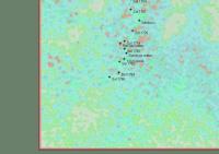
A first crude attempt to reduce the effects of bedrock on the terrain analysis
Basically a calculation of variance on relative brightness values (differences from average brightness) where after a second filter finds area's which have a considerably higher brightness then there surroundings over a larger area and mark these area's green, leaving only dunes marked blue or red. It is still not perfect and requires quite a bit of playing with settings before you get a 'reasonable' picture, so it remains work in progress. I'm working on a second filter to spot craters, which looks hopeful providing the crater is more or less 'round'... Regards, Geert. |
|
 |
 
|
|
|
Feb 4 2009, 03:18 AM
Post
#797
|
|
 Senior Member Group: Members Posts: 1229 Joined: 24-December 05 From: The blue one in between the yellow and red ones. Member No.: 618 |
This all hurts my head - It's so cool and esoteric!
 Tell me, Geert, is your 'bedrock-identifying filter' able to recognize that the bedrock is predominantly very bright 'evaporite', crisscrossed by quite narrow (less than 2 or 3 cm wide) sand-dark (or shadow-dark) lines. It seems to me that the close juxtaposition of sand-dark lines with evaporite-bright areas that constitute the bulk of the surface area (I'm guesstimating upward of 70%), will only be found on exposed bedrock, never on totally sandy areas. YMMV. 
-------------------- My Grandpa goes to Mars every day and all I get are these lousy T-shirts!
|
|
|
|
|
Feb 4 2009, 03:43 AM
Post
#798
|
|
|
Member Group: Members Posts: 236 Joined: 5-June 08 From: Udon Thani Member No.: 4185 |
I can't identify lines of 2-3 cm wide on HiRISE images which have a resolution of 25 cm...
But you're absolutely right, that seems the best description of 'bedrock' and it might work if you use pancam or navcam images (I can convert pancam/navcam to polar view and then project on the HiRISE map, but then you have only a very small area to work in). Presently I'm just identifying area's which have a very bright signature and extend over several pixels in all directions (small bright lines might be dunes). Hard thing is to distinguish from crater walls (which are also partly exposed bedrock, however often not 'nice' for driving), but I'll work on craters later ;-). Regards, Geert. |
|
|
|
|
Feb 4 2009, 06:01 AM
Post
#799
|
|
|
Senior Member Group: Members Posts: 1229 Joined: 24-December 05 From: The blue one in between the yellow and red ones. Member No.: 618 |
That's the crazy part of it, Geert: The cracks in the bedrock are too narrow to be resolved by HiRISE! Just like the shadow of the camera mast on Oppy was too narrow to be seen at Victoria.
But I can see them all in the highest resolution HiRise views!! So what gives??
-------------------- My Grandpa goes to Mars every day and all I get are these lousy T-shirts!
|
|
|
|
|
Feb 4 2009, 06:19 AM
Post
#800
|
|
 Senior Member Group: Admin Posts: 4763 Joined: 15-March 05 From: Glendale, AZ Member No.: 197 |
Actually you are not seeing the cracks Shaka. You are seeing subtle discontinuities in the textures on either side of the cracks. The human mind is capable of discerning minor contrasting details in a relative context that it is unable to discern in a homogeneous observation.
-------------------- If Occam had heard my theory, things would be very different now.
|
|
|
|
|
Feb 4 2009, 02:39 PM
Post
#801
|
|
|
Member Group: Senior Member Posts: 136 Joined: 8-August 06 Member No.: 1022 |
QUOTE (ElkGroveDan @ Feb 3 2009, 10:19 PM)  Actually you are not seeing the cracks Shaka. You are seeing subtle discontinuities in the textures on either side of the cracks. The human mind is capable of discerning minor contrasting details in a relative context that it is unable to discern in a homogeneous observation. This is similar to an amateur astronomer "seeing" the Encke Gap in Saturn's rings with a telescope who's theoretical resolution limit is greater than the ~0.2 arc second width of the gap. It's the contrast! Perhaps a more relevant comparison is resolution of the individual wheel tracks of the rovers by HiRISE, though in that case the wheels are almost a pixel wide. Or the detection of the rover tracks by MOC, who's pixels spanned the wheel spacing plus change. best, -Tim. |
|
|
|
|
Feb 7 2009, 05:06 PM
Post
#802
|
||
|
Member Group: Members Posts: 236 Joined: 5-June 08 From: Udon Thani Member No.: 4185 |
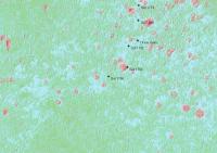
A first preliminary attempt at 'fingerprint-scanning' for hidden craters in the dunefields, craters (both visible and 'filled in') are marked red. Ranger and Surveyor crater are correctly found, as are some others. Smaller craters are not marked as they were outside the limits set for this search (I can define a minimum and maximum diameter to search for). Still some craters are missed which should have been found and there are a lot of seeminly 'false positives', but this remains 'work in progress'...
I'm mostly trying to find signs of 'dusttraps', craters which are filled in by sanddunes and mostly hidden from view, but it remains a nasty puzzle to get the software to find the exact signs for that ;-). Still, the dune-fields are a nice testbed, in flat area's the software now correctly finds almost all craters but inside these dunefields it's a lot harder... Regards, Geert |
|
|
|
|
|
|
Feb 7 2009, 11:53 PM
Post
#803
|
||
|
Member Group: Members Posts: 236 Joined: 5-June 08 From: Udon Thani Member No.: 4185 |
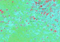
Combined view of terrain model and crater-search around the present position
Green is normal driving area. Rough sand dunes as well as craters and potential sand-traps (craters hidden by dunes) turn red. Bedrock remains unaffected unless blocked by potential crater. Starts to look 'interesting' but it remains preliminary, no guarantees given ;-). Regards, Geert |
|
|
|
|
|
|
Feb 9 2009, 05:05 PM
Post
#804
|
|||||
|
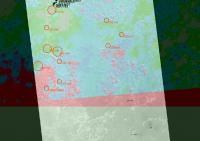
Member Group: Members Posts: 236 Joined: 5-June 08 From: Udon Thani Member No.: 4185 |
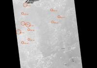
It has been remarked in this forum already that the area we are now entering looks like a old crater with 350-400 mtr diameter, completely filled in with sand.
Actually looking at the terrain ahead there seem to be quite a lot more of these structures, or at least there are 'round holes' which do not seem to have any exposed bedrock inside of them while they are surrounded by patches of bedrock.
Above image are just a few examples of area's which seem to comply to this description, don't know whether I'm seeing ghosts or whether some of them are really old craters?
In above overlay of IR relative brightness only a few of these 'craters' seem to show up but basically the sand inside does not seem to differ from the sand outside of these patches.
Looking at the relative brightness of the HiRISE image itself (visible red light) the result is even less pronounced then in IR and once again seemingly there is no difference between sand inside and outside of these area's.
On the variance model these areas seem to mostly show less dune ripples then their surroundings, but this might be influenced by the fact that there is no exposed bedrock inside these areas (which influences the variance model). Don't know whether we are seeing here shades of a much older landscape (later covered by the sand)? Anyway, I don't seem to find any indication that the sand itself (=drivability) inside these area's is any different from the sand everywhere else, apart from maybe slightly less dunes. Regards, Geert. |
||||
|
|
|
||||
|
Feb 9 2009, 09:02 PM
Post
#805
|
|
|
Member Group: Members Posts: 530 Joined: 21-March 06 From: Canada Member No.: 721 |
QUOTE (Geert @ Feb 9 2009, 11:05 AM) It has been remarked in this forum already that the area we are now entering looks like a old crater with 350-400 mtr diameter, completely filled in with sand. Yes, but some of us don't really read this discussion because we find it drier than,... well, Mars.
|
|
|
|
|
Feb 10 2009, 01:29 PM
Post
#806
|
|
|
Member Group: Members Posts: 236 Joined: 5-June 08 From: Udon Thani Member No.: 4185 |
QUOTE (BrianL @ Feb 10 2009, 04:02 AM) Yes, but some of us don't really read this discussion because we find it drier than,... well, Mars. Ah, but we're searching for the water!  Regards, Geert. |
|
|
|
|
Feb 10 2009, 02:53 PM
Post
#807
|
|
 Junior Member Group: Members Posts: 57 Joined: 17-May 06 From: Houston, Texas Member No.: 776 |
Drive Map
I was looking at the latest map. It looks like a rough circular area without any exposed bedrock. And ancient and very eroded crater? I am thinking Opportunity should avoid it and head southeast. -------------------- |
|
|
|
|
Feb 10 2009, 02:55 PM
Post
#808
|
|
|
Junior Member Group: Members Posts: 57 Joined: 17-May 06 From: Houston, Texas Member No.: 776 |
QUOTE (Geert @ Feb 9 2009, 12:05 PM) It has been remarked in this forum already that the area we are now entering looks like a old crater with 350-400 mtr diameter, completely filled in with sand. It looks like you guys beat me to that conclusion. -------------------- |
|
|
|
|
Feb 11 2009, 10:25 AM
Post
#809
|
||
|
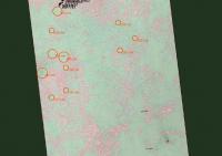
Member Group: Members Posts: 236 Joined: 5-June 08 From: Udon Thani Member No.: 4185 |
Terrain model for Sol 1795, looks like mostly smooth driving ahead with only one suspect area abt 120 mtr almost due south. Regards, Geert |
|
|
|
|
|
|
Feb 14 2009, 06:32 PM
Post
#810
|
||
|
Member Group: Members Posts: 236 Joined: 5-June 08 From: Udon Thani Member No.: 4185 |
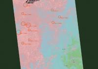
Terrain model for area south of Sol 1797 position at 1 mtr/pixel
This is a combination of two mathematical filters, one filter is mostly based on relative variance and marks "dangerous" dunes and craters, the other filter attempts to mark area's with potentially higher then usual dust concentrations ("dusttraps"). |
|
|
|
|
|
|

|
Lo-Fi Version | Time is now: 28th May 2024 - 05:41 PM |
|
RULES AND GUIDELINES Please read the Forum Rules and Guidelines before posting. IMAGE COPYRIGHT |
OPINIONS AND MODERATION Opinions expressed on UnmannedSpaceflight.com are those of the individual posters and do not necessarily reflect the opinions of UnmannedSpaceflight.com or The Planetary Society. The all-volunteer UnmannedSpaceflight.com moderation team is wholly independent of The Planetary Society. The Planetary Society has no influence over decisions made by the UnmannedSpaceflight.com moderators. |
SUPPORT THE FORUM Unmannedspaceflight.com is funded by the Planetary Society. Please consider supporting our work and many other projects by donating to the Society or becoming a member. |
|