Endeavour Drive - Drivability analysis |

  |
Endeavour Drive - Drivability analysis |
 Jun 15 2009, 06:33 AM Jun 15 2009, 06:33 AM
Post
#856
|
|
 Senior Member  Group: Members Posts: 2173 Joined: 28-December 04 From: Florida, USA Member No.: 132 |
QUOTE (BrianL @ Jun 14 2009, 10:30 PM)  Wow, I can see Oppy high-tailing as she bounds through the ripples.... My apologies to those of you who can't stand a little unrealistic anthropomorphizing.  That certainly is unrealistic anthropomorphizing! More realistic would be a pigeon-toed oldster shuffling along at one meter per minute. |
 |
 
|
|
Jun 19 2009, 03:53 AM
Post
#857
|
|
 Member Group: Members Posts: 813 Joined: 8-February 04 From: Arabia Terra Member No.: 12 |
I finished the map extension on Monday but have only now found a place to post it- it's located here and is split into three parts.
This isn't something I had originally intended to do. If I had planned this from the outset I would have used a more sophisticated method of making the tiles than just saving images from the IAS viewer! Initially all I wanted was to see just a little bit more terrain off to the west but I found that increasing the coverage was a bit like pulling at a loose thread and before I knew it I was all the way to Endeavour. Anyway, I've decided to stop at this point. I may decide to do things properly in the future and start over again. First I will need to find some software to break the JP2s into full resolution 8192X8192 chunks that slightly overlap each other. |
|
|
|
|
Jun 19 2009, 07:48 AM
Post
#858
|
|
 Senior Member Group: Moderator Posts: 2262 Joined: 9-February 04 From: Melbourne - Oz Member No.: 16 |
QUOTE (SFJCody @ Jun 19 2009, 04:53 AM) Anyway, I've decided to stop at this point. I may decide to do things properly in the future and start over again. First I will need to find some software to break the JP2s into full resolution 8192X8192 chunks that slightly overlap each other. I have some scripts to do this, let me know if you decide to do it and I can probably make the chunks for you and throw them on my webspace. James -------------------- |
|
|
|
|
Jun 26 2009, 10:05 PM
Post
#859
|
|
|
Senior Member Group: Moderator Posts: 4279 Joined: 19-April 05 From: .br at .es Member No.: 253 |
Just thinking out loud but it would be great to have this map coverage implemented using nested regions (regions + LOD). It's a LOT of work and I presume the only (sane) way to do it is with some automated software.
|
|
|
|
|
Jun 27 2009, 06:42 AM
Post
#860
|
|
|
Member Group: Members Posts: 813 Joined: 8-February 04 From: Arabia Terra Member No.: 12 |
QUOTE (jamescanvin @ Jun 19 2009, 08:48 AM) I have some scripts to do this, let me know if you decide to do it and I can probably make the chunks for you and throw them on my webspace. Cheers for that, that would be great! First image to do should probably be the map-projected ESP_011765_1780. Each tile should have something like a 5 % overlap with all the neighbouring tiles. I won't be able to start right now though as I have some issues to fix with my PC. I'm also wondering whether it would be worth completely re-doing the pre-existing HiRISE frame as it just does not seem to match up well with the HRSC and MOLA data. That's why the topography of the hills at the edge of Endeavour looks a bit odd in my map extension- the overlay is too far to the NE. |
|
|
|
|
Jun 27 2009, 07:49 AM
Post
#861
|
|
|
Member Group: Members Posts: 813 Joined: 8-February 04 From: Arabia Terra Member No.: 12 |
QUOTE (Tesheiner @ Jun 26 2009, 11:05 PM) It's a LOT of work and I presume the only (sane) way to do it is with some automated software. I'm now thinking that it might not be that difficult. Sure, there will be 16 times as many pixels to map but the real issue is how many tiles there will be. As each tile (at 8192X8192) will have about 37 times as many pixels as my original tiles it might be 2.3 times easier! |
|
|
|
|
Jun 27 2009, 10:39 AM
Post
#862
|
|
|
Senior Member Group: Moderator Posts: 2262 Joined: 9-February 04 From: Melbourne - Oz Member No.: 16 |
I'll see what I can do - babies take up a lot of time so no promises!
What format do you want the output? jpg, png? presumably 8bit? -------------------- |
|
|
|
|
Jun 27 2009, 05:10 PM
Post
#863
|
|
|
Senior Member Group: Moderator Posts: 2262 Joined: 9-February 04 From: Melbourne - Oz Member No.: 16 |
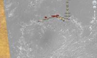
PM sent to SFJCody with the tiles. If anyone else has a use for full resolution 8192x8192 JPG chunks of ESP_011765_1780 let me know.
While doing that I also ran my ripple mapping tool on that image.  I await to see what the 'possible' route is - maybe folloing the bedrock out crops something like this...  (Both images link to same blog post with larger versions) James -------------------- |
|
|
|
|
Jun 28 2009, 09:01 AM
Post
#864
|
|
|
Member Group: Members Posts: 813 Joined: 8-February 04 From: Arabia Terra Member No.: 12 |
QUOTE (Tesheiner @ Jun 26 2009, 11:05 PM) Just thinking out loud but it would be great to have this map coverage implemented using nested regions (regions + LOD). I'm looking into various ways of doing nested regions. Also I'm wondering if I should abandon trying to match the existing HiRISE frame and switch to matching introduced HiRISE images to either the CTX image or the HRSC image. Either of these two look like they will provide a better fit to the topography data around Endeavour than extending the positions of the current embeded image, which seems out of alignment. Of course, the downside is that the entire route map will have to be redrawn and the DTM of Victoria created from rover data will be out of sync! |
|
|
|
|
Jun 28 2009, 09:16 PM
Post
#865
|
|
|
Senior Member Group: Moderator Posts: 4279 Joined: 19-April 05 From: .br at .es Member No.: 253 |
Actually, you can keep both options.
 The BIG amount of data are the JPEGs and they would be the same on both a) HiRISE to HiRISE match and  HiRISE to CTX match. The "only" change would be on the control information in the KML files where the position of the pictures would have to be offset in options a) and . HiRISE to CTX match. The "only" change would be on the control information in the KML files where the position of the pictures would have to be offset in options a) and .I still prefer option a) for obvious reasons. 
|
|
|
|
|
Jun 28 2009, 09:22 PM
Post
#866
|
|
|
Member Group: Members Posts: 813 Joined: 8-February 04 From: Arabia Terra Member No.: 12 |
QUOTE (Tesheiner @ Jun 28 2009, 10:16 PM) The "only" change would be on the control information in the KML files where the position of the pictures would have to be offset Good point, good point. I guess I could make the first mosaic fit the existing HiRISE and then simply batch modify all the kmls to make a version that provides a better alignment around Endeavour. |
|
|
|
|
Jul 6 2009, 08:11 PM
Post
#867
|
||
|
Member Group: Members Posts: 813 Joined: 8-February 04 From: Arabia Terra Member No.: 12 |
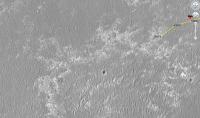
Version 2 preview, not at full resolution. I'm trying various pieces of overlay software to find out which is the best at automating the process of making nested regions. Will upload later this week.
Attached thumbnail(s)
|
|
|
|
|
|
|
Sep 27 2009, 08:10 AM
Post
#868
|
|||
|
Member Group: Members Posts: 813 Joined: 8-February 04 From: Arabia Terra Member No.: 12 |
Well, I've finally decided to upload version 2.0! What with Opportunity about to rove off the current HiRISE frame there aren't really any excuses left to be made. I kind of abandoned this in July because I wasn't happy with how it was running but hopefully there will be some kml experts out there who can suggest ways to reduce the time it spends loading images (which will then feed into 2.* and so on).
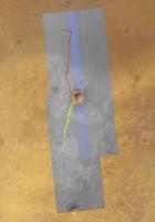
It's an unholy chimera of a thing created using a combination of methods because the super-overlay tool I was using had a bizarre problem when I tried to create region files within a particular latitude band on Mars. Anyway, the final product more-or-less sort-of works. Just don't try to fly horizontally at high speed over the landscape because it might crash Google Earth.  It's available as a torrent here: Torrent link If you don't have a BitTorrent client to download this with I recommend using µTorrent. Google Earth recommendations: If you have not done so and your computer is capable of handling it it would be a good idea to increase Google Earth's memory cache size to 500Mb (go to tools -> options -> cache). It's probably best to remove version 1.0 first, otherwise it might prove a bit taxing. To run, unzip the whole folder and open the file "MER-B map extension version 2.0.kml" located within. Thanks again to James Canvin for splitting the HiRISE frame. Some screenshots (with Tesheiner's route map):
Attached thumbnail(s)
|
||
|
|
|
||
|
Sep 27 2009, 04:46 PM
Post
#869
|
|
|
Founder Group: Chairman Posts: 14432 Joined: 8-February 04 Member No.: 1 |
Thanks for the torrent - it's coming down now, and I'll be seeding it all night if anyone wants to try and grab it - for about the next 14 hrs.
|
|
|
|
|
Sep 27 2009, 08:44 PM
Post
#870
|
|
|
Senior Member Group: Moderator Posts: 4279 Joined: 19-April 05 From: .br at .es Member No.: 253 |
Thanks too!
It takes a bit of time loading on GE but after that, it is smooth navigation and will be very useful in this part of the trek. |
|
|
|
|

|
Lo-Fi Version | Time is now: 28th May 2024 - 03:15 AM |
|
RULES AND GUIDELINES Please read the Forum Rules and Guidelines before posting. IMAGE COPYRIGHT |
OPINIONS AND MODERATION Opinions expressed on UnmannedSpaceflight.com are those of the individual posters and do not necessarily reflect the opinions of UnmannedSpaceflight.com or The Planetary Society. The all-volunteer UnmannedSpaceflight.com moderation team is wholly independent of The Planetary Society. The Planetary Society has no influence over decisions made by the UnmannedSpaceflight.com moderators. |
SUPPORT THE FORUM Unmannedspaceflight.com is funded by the Planetary Society. Please consider supporting our work and many other projects by donating to the Society or becoming a member. |
|