The western route, 5th leg after stop at Absecon / Reeds Bay |

  |
The western route, 5th leg after stop at Absecon / Reeds Bay |
 Aug 7 2009, 02:55 AM Aug 7 2009, 02:55 AM
Post
#256
|
||
|
Member  Group: Members Posts: 808 Joined: 10-October 06 From: Maynard Mass USA Member No.: 1241 |
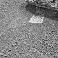
pedestal or not....(cont.)
here is a pancam view that has been processed using a (slightly modified) classic CLAHE technique (seeing in shadows) * The transition from shadow to light has a processing illusion that makes the shadow look depressed (ignore it) * The other observation is that the jpeg compression in the uniform dark shadow becomes very apparent as the histogram is equalized... my interpretation is that this just a pavement chunk that we have seen all over the planum. The pavement takes a jog to the left under BI so that it appears to be a vertical structure (i.,e. pedestal from the camera's POV) if you put your finger over that left jog under BI the illusion goes away and it looks like pavement. I am fairly confident that the left jog does not touch BI. Another image from a different angle (move the rover) will add more data ...your mileage may vary...
cheers -------------------- CLA CLL
|
|
 |
 
|
|
|
Aug 7 2009, 06:14 AM
Post
#257
|
|
 Senior Member Group: Members Posts: 2228 Joined: 1-December 04 From: Marble Falls, Texas, USA Member No.: 116 |
QUOTE (CryptoEngineer @ Aug 6 2009, 09:46 AM)  I'm trying to picture how such a pedestal could form. ... Have I got it right? It seems to me that if we really aren't sure if this is a pedestal or not, there's an easy way to find out: Spirit has been using its MI to get some notion as to what's going on underneath it. Oppy could use it to get a worms-eye view of the base of BI, and see if there is daylight around the edges of BI. ... I don't know if you've got it right or not, but your analysis is pretty much the way I see it. The imagery available is provocative, but we can't be certain that the feature being discussed is truly an erosional pedestal, protected by its caprock. I like your idea of using the MI for a closer inspection, but it would be very unusual for the team to use the MI for a task it was not designed for. I think it would also be quite surprising to see them using the rover to intentionally study "geomorphic" processes on Mars. One would have to suspect that an overlying, resistant rock would tend to protect its base from aeolian erosion, but aside from this rock, we really haven't seen any other obvious pedestals beneath other resistant rocks in the region, or have we? -------------------- ...Tom
I'm not a Space Fan, I'm a Space Exploration Enthusiast. |
|
|
|
|
Aug 7 2009, 06:32 AM
Post
#258
|
|
|
Merciless Robot Group: Admin Posts: 8783 Joined: 8-December 05 From: Los Angeles Member No.: 602 |
I'm going to jump on PDP's bandwagon, actually; that paving stone does look like it jogs to the left, and the underside illumination is tricky enough to play perspective tricks. More data definitely needed, though.
Re studying "geomorphic" features: CR, I think that if in fact this is a pedestal that would indeed be a significant finding worth detailed examination since it could tell us some things about the gross history of Meridiani. Not a Rosetta Stone by any means, but if the overall 'floor' has eroded since BI's been in place (however long THAT is) that would pose the question of why it's so generally uniform & level everywhere else we've seen. Eolian erosion usually doesn't produce flat surfaces; it removes it from one place & piles it up elsewhere (so I'd expect BI to have a tail dune). Furthermore, that might mean that even the local weather patterns have been extraordinarily constant for a very long time, and that might have some implications for the cyclical climate theories. -------------------- A few will take this knowledge and use this power of a dream realized as a force for change, an impetus for further discovery to make less ancient dreams real.
|
|
|
|
|
Aug 7 2009, 03:42 PM
Post
#259
|
|
 Senior Member Group: Members Posts: 2173 Joined: 28-December 04 From: Florida, USA Member No.: 132 |
QUOTE (nprev @ Aug 7 2009, 01:32 AM) ...if the overall 'floor' has eroded since BI's been in place (however long THAT is) that would pose the question of why it's so generally uniform & level everywhere else we've seen.... Whether it occurred before or after BI arrived, I thought the presence of the layer of loose berries on the surface indicated a meter or so of rock which once contained the berries having been worn away. Am I wrong in assuming that the loose berries indicate a 'proven' removal of about a meter of rock from Opportunity's stomping grounds (according to the mainstream hypothesis)? |
|
|
|
|
Aug 8 2009, 12:40 AM
Post
#260
|
|
 Senior Member Group: Members Posts: 3419 Joined: 9-February 04 From: Minneapolis, MN, USA Member No.: 15 |
I thought the theory here was that the northern plains (where Oppy landed) are blueberry-paved deposits formed as you described, with the deflation of a good meter or so of soft sulfate-rich sandstone that halted when the freed concretions provided an anti-aeolian "armor." The remains of the sulfate rock that was blown away composes the extensive ripple structures to the south (through which we're currently traveling). This terrain didn't have as many concretions buried in its sandstone layers, and so never developed the full armoring. Instead, ripple structures protect the remaining sandstone paving in the ripple fields from further erosion.
-the other Doug -------------------- The trouble ain't that there is too many fools, but that the lightning ain't distributed right. -Mark Twain
|
|
|
|
|
Aug 8 2009, 06:14 PM
Post
#261
|
||
 Senior Member Group: Members Posts: 4246 Joined: 17-January 05 Member No.: 152 |
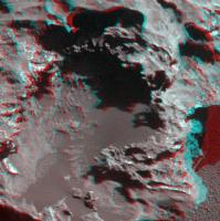
Here's my attempt at an anaglyph from the sol 1961 pancam closeup of the big jagged pit:
This included a 20.7 degree relative rotation. The result still isn't perfect, but hopefully I've minimized headaches from viewing this... |
|
|
|
|
|
|
Aug 9 2009, 10:47 AM
Post
#262
|
||
 The Poet Dude Group: Moderator Posts: 5551 Joined: 15-March 04 From: Kendal, Cumbria, UK Member No.: 60 |
Based on pics and Google Earth files posted in the Opportunity route thread, is Block Island just visible on a HiRISE image at full mag..?
-------------------- |
|
|
|
|
|
|
Aug 9 2009, 11:02 AM
Post
#263
|
|
|
Founder Group: Chairman Posts: 14432 Joined: 8-February 04 Member No.: 1 |
Yes - it is - after all, Tim said it was

|
|
|
|
|
Aug 9 2009, 11:48 AM
Post
#264
|
|
 Member Group: Members Posts: 237 Joined: 22-December 07 From: Alice Springs, N.T. Australia Member No.: 3989 |
QUOTE (fredk @ Aug 9 2009, 03:44 AM) anaglyph big jagged pit Really good - great sense of depth. Those two stalks sticking out at the bottom look really fragile. There's a couple or so more smaller similar structures around the edge of the hole. Fascinating. Anyone, any idea what sort of erosional processes might have been responsible? |
|
|
|
|
Aug 9 2009, 11:54 AM
Post
#265
|
|
|
The Poet Dude Group: Moderator Posts: 5551 Joined: 15-March 04 From: Kendal, Cumbria, UK Member No.: 60 |
QUOTE (djellison @ Aug 9 2009, 12:02 PM) Yes - it is - after all, Tim said it was Must have missed that post, sorry. -------------------- |
|
|
|
|
Aug 9 2009, 01:14 PM
Post
#266
|
|
|
Newbie Group: Members Posts: 11 Joined: 14-September 08 From: Rome, Italy Member No.: 4343 |
QUOTE (djellison @ Aug 9 2009, 01:02 PM) Yes - it is - after all, Tim said it was What are the HiRISE guys waiting to take a shot with Oppy?  Ok. Back to lurking... Ermanno |
|
|
|
|
Aug 9 2009, 02:57 PM
Post
#267
|
|
|
Senior Member Group: Members Posts: 2173 Joined: 28-December 04 From: Florida, USA Member No.: 132 |
QUOTE (HughFromAlice @ Aug 9 2009, 06:48 AM) ...Those two stalks sticking out at the bottom look really fragile.... any idea what sort of erosional processes might have been responsible? I wonder if they started as products of the plunge onto Mars. Streamers of molten iron refrozen before impact. Or perhaps they were formed during the creation of the original asteroid. Of course, weathering on Mars would have taken place as well. |
|
|
|
|
Aug 9 2009, 03:16 PM
Post
#268
|
|
|
Senior Member Group: Members Posts: 2173 Joined: 28-December 04 From: Florida, USA Member No.: 132 |
QUOTE (erpol @ Aug 9 2009, 09:14 AM) What are the HiRISE guys waiting to take a shot with Oppy? They're preoccupied at the time. But you're right, an MRO image of Opportunity at BI would be great. "The powerful Mars Reconnaissance Orbiter (MRO) unexpectedly switched to its redundant Side B computer and subsystems before entering a protective safe mode on Thursday....'Taking the spacecraft back out of safe mode is one of the earlier steps in resuming full science operations, which is expected to take several days,' Webster added." |
|
|
|
|
Aug 9 2009, 04:56 PM
Post
#269
|
|
 Senior Member Group: Moderator Posts: 2262 Joined: 9-February 04 From: Melbourne - Oz Member No.: 16 |
Catching up with recent drive direction mosaics.
All these link to the same page Sol 1910  Sol 1912  Sol 1920  Sol 1942  Sol 1946  Sol 1947  James -------------------- |
|
|
|
|
Aug 9 2009, 05:36 PM
Post
#270
|
|
|
Senior Member Group: Moderator Posts: 2262 Joined: 9-February 04 From: Melbourne - Oz Member No.: 16 |
And the Reeds Bay Pan:
 James -------------------- |
|
|
|
|

|
Lo-Fi Version | Time is now: 27th April 2024 - 10:55 PM |
|
RULES AND GUIDELINES Please read the Forum Rules and Guidelines before posting. IMAGE COPYRIGHT |
OPINIONS AND MODERATION Opinions expressed on UnmannedSpaceflight.com are those of the individual posters and do not necessarily reflect the opinions of UnmannedSpaceflight.com or The Planetary Society. The all-volunteer UnmannedSpaceflight.com moderation team is wholly independent of The Planetary Society. The Planetary Society has no influence over decisions made by the UnmannedSpaceflight.com moderators. |
SUPPORT THE FORUM Unmannedspaceflight.com is funded by the Planetary Society. Please consider supporting our work and many other projects by donating to the Society or becoming a member. |
|