Post Block Island Meteor Studies (The Western Route), The 6th Leg in our Zig Zag Journey to Endeavour Crater |

  |
Post Block Island Meteor Studies (The Western Route), The 6th Leg in our Zig Zag Journey to Endeavour Crater |
| Guest_Sunspot_* |
 Oct 23 2009, 11:12 AM Oct 23 2009, 11:12 AM
Post
#421
|
|
Guests |
And that big crater bottom left gets my vote after they finish with Endeavour.

|
 |
 
|
|
Oct 23 2009, 12:03 PM
Post
#422
|
||
|
Senior Member  Group: Moderator Posts: 4279 Joined: 19-April 05 From: .br at .es Member No.: 253 |
QUOTE (ustrax @ Oct 23 2009, 11:55 AM)  btw, does that crater have a name?  Google (Mars) is your friend.
QUOTE (Sunspot @ Oct 23 2009, 01:12 PM) And that big crater bottom left gets my vote after they finish with Endeavour. Oh! No problem at all; it's "only" 50km away... |
|
|
|
|
|
|
Oct 23 2009, 02:07 PM
Post
#423
|
|
|
Member Group: Senior Member Posts: 136 Joined: 8-August 06 Member No.: 1022 |
I've been looking for Bopolu in the horizon pans, when we get to take them in that direction. I think we should be able to see it at some point, particularly as we roll off this "nose" of topography we're on and start our descent toward Endeavour - the topo also drops off to the southwest of us, and the intevening surface should 'get out of our way' soon.
-Tim. |
|
|
|
|
Oct 23 2009, 02:46 PM
Post
#424
|
|
|
Member Group: Members Posts: 877 Joined: 7-March 05 From: Switzerland Member No.: 186 |
That should be the intervening surface in southwest direction (~227°)
http://marsrovers.jpl.nasa.gov/gallery/all...GP2427R1M1.HTML If my math is correct, in the distance of 50km the rim have to be at least 368m... eh, ~370m high to appear over a flat horizon. -------------------- |
|
|
|
|
Oct 23 2009, 03:09 PM
Post
#425
|
|
|
Senior Member Group: Moderator Posts: 4279 Joined: 19-April 05 From: .br at .es Member No.: 253 |
QUOTE (tim53 @ Oct 23 2009, 04:07 PM) ... I think we should be able to see it at some point, particularly as we roll off this "nose" of topography we're on and start our descent toward Endeavour - the topo also drops off to the southwest of us, and the intevening surface should 'get out of our way' soon. Could you point out the "high point" of our current path? More or less the point in which we could get a clear horizon view? |
|
|
|
|
Oct 23 2009, 03:40 PM
Post
#426
|
|
|
Member Group: Members Posts: 311 Joined: 31-August 05 From: Florida & Texas, USA Member No.: 482 |
QUOTE (Tesheiner @ Oct 23 2009, 06:03 AM) Google (Mars) is your friend. Oh! No problem at all; it's "only" 50km away... I like this thinking!  Let's see, we're just approaching the 19km mark, so just another 15 years and we're there? It is interesting that of the 4 craters in that Google image, all have obvious ejacta aprons except Endeavour. Does that imply Endeavour is much more ancient, or does it hint that the geology is different? (and apologies in advance if I'm regurgitating previous posts) |
|
|
|
|
Oct 23 2009, 03:58 PM
Post
#427
|
|
|
Member Group: Members Posts: 235 Joined: 2-August 05 Member No.: 451 |
QUOTE (Marz @ Oct 23 2009, 10:40 AM) It is interesting that of the 4 craters in that Google image, all have obvious ejacta aprons except Endeavour. Does that imply Endeavour is much more ancient, or does it hint that the geology is different? (and apologies in advance if I'm regurgitating previous posts) Speaking not as a geologist, but as someone who played on the beach as a kid, Endeavor looks like a crater made in wet sand. |
|
|
|
|
Oct 23 2009, 04:02 PM
Post
#428
|
|
|
Member Group: Senior Member Posts: 136 Joined: 8-August 06 Member No.: 1022 |
QUOTE (Tesheiner @ Oct 23 2009, 07:09 AM) Could you point out the "high point" of our current path? More or less the point in which we could get a clear horizon view? I'm off work today, so it'll have to wait until Monday. Problem is that the MOLA topography is pretty coarse in longitude in particular, so there could be higher frequency topography in the near and mid distance that isn't resolved by MOLA. Plus, we're near the edge of a large convergence angle stereo pair taken around April, so I can't see the smaller features in the stereo either. But in general we should be able to see more as we progress south and southeast from our current location. We have to take a gander periodically, which requires pointing pancam in the direction we're not driving. Probably albedo pans are our best bet for dection followed by targeted imaging. Or Navcam if the Bopolu rim is high enough to show at that scale. -Tim. |
|
|
|
|
Oct 23 2009, 04:05 PM
Post
#429
|
|
 Member Group: Members Posts: 656 Joined: 20-April 05 From: League City, Texas Member No.: 285 |
QUOTE (Marz @ Oct 23 2009, 09:40 AM) It is interesting that of the 4 craters in that Google image, all have obvious ejacta aprons except Endeavour. As I recall, the thought is that Endeavour is very old, and the older terrain is draped by overlying sediment. The rim of Endeavour apparently is elevated above the sediment and has a distinctly different composition than what we've seen so far ... which is why it is an interesting destination to drive towards. Oppy has been driving over the overlying sediment all along, so reaching the rim of Endeavour would be a chance to see some really new geology. An argument may also be made that water may once have pooled within Endeavour, making for further interesting geology. The other craters, being more recent, would lack all or part of the sediment draping. Iazu (to the south in the Google Mars image) has the "splosh" outline characteristic of an impact into wet/icy terrain, while Bopolu (to the southwest) seems to lack this, perhaps indicative of different eras at the time of impact. |
|
|
|
|
Oct 23 2009, 04:05 PM
Post
#430
|
|
|
Member Group: Senior Member Posts: 136 Joined: 8-August 06 Member No.: 1022 |
QUOTE (Marz @ Oct 23 2009, 07:40 AM) I like this thinking! Let's see, we're just approaching the 19km mark, so just another 15 years and we're there? It is interesting that of the 4 craters in that Google image, all have obvious ejacta aprons except Endeavour. Does that imply Endeavour is much more ancient, or does it hint that the geology is different? (and apologies in advance if I'm regurgitating previous posts) Endeavour is "under" the Meridiani sulfate deposits, poking through them, whereas Bopolu and Iazu formed after the deposits were laid down. -Tim. |
|
|
|
|
Oct 23 2009, 04:20 PM
Post
#431
|
|
 Senior Member Group: Admin Posts: 4763 Joined: 15-March 05 From: Glendale, AZ Member No.: 197 |
QUOTE (tim53 @ Oct 23 2009, 08:05 AM) Bopolu and Iazu formed after the deposits were laid down. That fits with the impression I get of Bopolu that it looks like one of those "splat" craters in the icy soil regions. I'd be willing to predict that there would be evidence of flowing water on the downslope regions of the denser ejecta apron. In fact if you look at about the five o'clock position on Bopolu some river-canyon features are definitely visible which would have been cut by brief catastrophic melt/flooding. -------------------- If Occam had heard my theory, things would be very different now.
|
|
|
|
|
Oct 23 2009, 04:41 PM
Post
#432
|
|
 Special Cookie Group: Members Posts: 2168 Joined: 6-April 05 From: Sintra | Portugal Member No.: 228 |
QUOTE (ElkGroveDan @ Oct 23 2009, 05:20 PM) river-canyon features Mark in your agendas...canyoning on Mars with Oppy by 2015. -------------------- "Ride, boldly ride," The shade replied, "If you seek for Eldorado!"
Edgar Alan Poe |
|
|
|
|
Oct 23 2009, 05:02 PM
Post
#433
|
|
 Senior Member Group: Members Posts: 4247 Joined: 17-January 05 Member No.: 152 |
QUOTE (Tman @ Oct 23 2009, 03:46 PM) If my math is correct, in the distance of 50km the rim have to be at least 368m... eh, ~370m high to appear over a flat horizon. I agree with your math. Can anyone estimate the height of Bopolu's rim above the surrounding plains using GM or whatever? |
|
|
|
|
Oct 23 2009, 06:21 PM
Post
#434
|
|
|
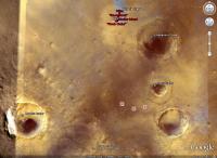
Member Group: Members Posts: 293 Joined: 22-September 08 From: Spain Member No.: 4350 |
|
|
|
|
|
Oct 23 2009, 07:10 PM
Post
#435
|
|
|
Senior Member Group: Members Posts: 3516 Joined: 4-November 05 From: North Wales Member No.: 542 |
There is an elevated 'island' almost due south of us at about the same distance. Actually it's at the end of a larger peninsula that seems to rise above the plains, perhaps part of a very large crater rim. That island does look as if it casts an appreciable shadow so might also be worth checking out if someone is working on elevations. It has the added advantage of being located front centre for a southbound traveller.
http://www.google.com/mars/#lat=-3.118576&...mp;q=spacecraft |
|
|
|
|

|
Lo-Fi Version | Time is now: 28th May 2024 - 04:24 AM |
|
RULES AND GUIDELINES Please read the Forum Rules and Guidelines before posting. IMAGE COPYRIGHT |
OPINIONS AND MODERATION Opinions expressed on UnmannedSpaceflight.com are those of the individual posters and do not necessarily reflect the opinions of UnmannedSpaceflight.com or The Planetary Society. The all-volunteer UnmannedSpaceflight.com moderation team is wholly independent of The Planetary Society. The Planetary Society has no influence over decisions made by the UnmannedSpaceflight.com moderators. |
SUPPORT THE FORUM Unmannedspaceflight.com is funded by the Planetary Society. Please consider supporting our work and many other projects by donating to the Society or becoming a member. |
|