Post Block Island Meteor Studies (The Western Route), The 6th Leg in our Zig Zag Journey to Endeavour Crater |

  |
Post Block Island Meteor Studies (The Western Route), The 6th Leg in our Zig Zag Journey to Endeavour Crater |
 Oct 26 2009, 09:06 PM Oct 26 2009, 09:06 PM
Post
#466
|
|
|
Junior Member  Group: Members Posts: 41 Joined: 27-May 09 From: Burgundy Member No.: 4798 |
We can see the crater in these previous pancams too, if this can help to check!
From sol 2042 : http://qt.exploratorium.edu/mars/opportuni...00P2430L6M1.JPG From sol 2043 : http://qt.exploratorium.edu/mars/opportuni...AXP2432L6M1.JPG |
 |
 
|
|
Oct 26 2009, 10:11 PM
Post
#467
|
|
 Senior Member Group: Admin Posts: 4763 Joined: 15-March 05 From: Glendale, AZ Member No.: 197 |
QUOTE (Tesheiner @ Oct 26 2009, 03:53 AM)  fitting perfectly with the heading of the fresh crater This is really great. With the stretched image you can see the darkened spot of the fresh crater, and in fact after looking at that you can go back and identify it in the unaltered version. -------------------- If Occam had heard my theory, things would be very different now.
|
|
|
|
|
Oct 27 2009, 08:56 AM
Post
#468
|
|
|
Senior Member Group: Moderator Posts: 4279 Joined: 19-April 05 From: .br at .es Member No.: 253 |
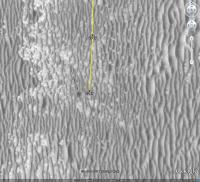
QUOTE (Bill @ Oct 26 2009, 10:06 PM) We can see the crater in these previous pancams too, if this can help to check! From sol 2042 : http://qt.exploratorium.edu/mars/opportuni...00P2430L6M1.JPG From sol 2043 : http://qt.exploratorium.edu/mars/opportuni...AXP2432L6M1.JPG Let me try with the first one. That image is from sol 2042 and the heading to the fresh crater should be, based on the overhead map, around 173º. I'll post later on with the results. |
|
|
|
|
Oct 27 2009, 09:17 AM
Post
#469
|
||
|
Senior Member Group: Moderator Posts: 4279 Joined: 19-April 05 From: .br at .es Member No.: 253 |
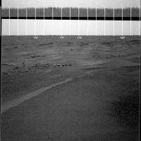
Here's the pancam image http://qt.exploratorium.edu/mars/opportuni...00P2430L6M1.JPG, with the horizon vertically exaggerated 5x and a ruler. The result is not conclusive.

|
|
|
|
|
|
|
Oct 27 2009, 09:59 AM
Post
#470
|
|
|
Member Group: Members Posts: 877 Joined: 7-March 05 From: Switzerland Member No.: 186 |
Could it be that the other (fainter) black line-like feature (slightly to the left and closer) is in fact fresh crater? The size would match too and the larger shift to the left (or right) would be more accurate.
-------------------- |
|
|
|
|
Oct 27 2009, 02:05 PM
Post
#471
|
|
|
Solar System Cartographer Group: Members Posts: 10168 Joined: 5-April 05 From: Canada Member No.: 227 |
-------------------- ... because the Solar System ain't gonna map itself.
Also to be found posting similar content on https://mastodon.social/@PhilStooke Maps for download (free PD: https://upload.wikimedia.org/wikipedia/comm...Cartography.pdf NOTE: everything created by me which I post on UMSF is considered to be in the public domain (NOT CC, public domain) |
|
|
|
|
Oct 27 2009, 02:53 PM
Post
#472
|
|||
|
Senior Member Group: Moderator Posts: 4279 Joined: 19-April 05 From: .br at .es Member No.: 253 |
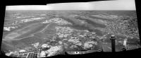
Today's drive was "only" 50m instead of the usual 70m. IMO the intention was to stop right beside this little crater (?) partially seen to the right of the navcam mosaic. Same image as posted by Phil.
|
||
|
|
|
||
|
Oct 27 2009, 03:27 PM
Post
#473
|
|
|
Senior Member Group: Members Posts: 2921 Joined: 14-February 06 From: Very close to the Pyrénées Mountains (France) Member No.: 682 |
As recentely the drives have been very very accurate, I would bet they stoped not to have a look at the crater but to be sure not to run into this "hazard" instead.
My guess. -------------------- |
|
|
|
|
Oct 27 2009, 03:35 PM
Post
#474
|
|
|
Founder Group: Chairman Posts: 14432 Joined: 8-February 04 Member No.: 1 |
Accuracy would infer they could reliably avoid such a crater if they so wished. They've stopped for a quick look.
|
|
|
|
|
Oct 27 2009, 03:58 PM
Post
#475
|
|
 Senior Member Group: Members Posts: 4247 Joined: 17-January 05 Member No.: 152 |
QUOTE (Tesheiner @ Oct 27 2009, 10:17 AM) The result is not conclusive. But the movement of the dark feature from 2042 to 2045 is in the right direction. Is the amount of the movement correct, without rounding to the degree? And there must be some uncertainties in the pancam headings. Since there's no other potential target near that heading, I'd say it's very likely this is "fresh crater." |
|
|
|
|
Oct 27 2009, 04:01 PM
Post
#476
|
|
|
Senior Member Group: Moderator Posts: 4279 Joined: 19-April 05 From: .br at .es Member No.: 253 |
QUOTE (climber @ Oct 27 2009, 04:27 PM) As recentely the drives have been very very accurate, I would bet they stoped not to have a look at the crater but to be sure not to run into this "hazard" instead. My guess. IMO, the stop was intentional for imaging. 02047::p0703::03::6::0::0::6::0::12::navcam_3x1_az_180_3_bpp 02047::p1211::03::2::0::0::2::0::4::ultimate_front_haz_1_bpp_pri_15 02047::p1254::02::2::0::0::2::0::4::front_haz_fault_pri15_4bpp 02047::p1312::07::2::0::0::2::0::4::rear_haz_ultimate_2_bpp_pri15 02047::p1354::01::2::0::0::2::0::4::rear_haz_fault_pri15_4bpp 02047::p1625::01::10::0::0::10::0::20::navcam_5x1_az_36_1_bpp 02047::p1882::03::4::0::0::4::0::8::navcam_2x1_pri32_az270_3bpp 02047::p1991::07::4::0::0::4::0::8::nav_2x1_rvraz_0_1_bpp_pri42 02047::p1994::05::1::0::0::1::0::2::nav_1x1_MovieFrame_Leye_1bpp_pri72 02047::p2102::14::3::0::3::0::1::7::pancam_isc_voc_cal_L267 02047::p2104::10::3::0::3::0::1::7::pancam_mtes_cal_target_L267 02047::p2435::20::12::0::0::12::2::26::pancam_drive_direction_4cx1r_L6R12 02047::p2601::03::4::2::0::0::2::8::pancam_tau_L78R48 02047::p2625::03::34::34::0::0::2::70::pancam_pre_sunset_L4578R2478 QUOTE (fredk @ Oct 27 2009, 04:58 PM) But the movement of the dark feature from 2042 to 2045 is in the right direction. Is the amount of the movement correct, without rounding to the degree? And there must be some uncertainties in the pancam headings. Since there's no other potential target near that heading, I'd say it's very likely this is "fresh crater." You read my mind. The movement was on the right direction and looking for today's pancams I would say the same. |
|
|
|
|
Oct 27 2009, 06:47 PM
Post
#477
|
|
|
Founder Group: Chairman Posts: 14432 Joined: 8-February 04 Member No.: 1 |
Since Block Island - 43 Sols, 1.2 km Average of 28m/sol even including the science stops, restricted sols etc.
That's not too shabby at all. The reasonably good driving terrain starts in another 2km or so - the sublime driving terrain another 1km thereafter. We're then 3km from Endurance 2.0 (I fancy calling it Aurora - have we had that one already? It was the ship that did the other side of the Antarctic from Endurance during Shackleton's expedition) in terrain that saw an average 100m/sol in the James Caird days. Then only another 6.3km till Endeavour. Yeah - we've still got a ways to go 
|
|
|
|
|
Oct 27 2009, 06:58 PM
Post
#478
|
|
|
Solar System Cartographer Group: Members Posts: 10168 Joined: 5-April 05 From: Canada Member No.: 227 |
Yes Doug - what might have looked like a pretty wild idea at first now seems well within reach. It's also interesting to compare the drifts we are seeing now with those treacherous piles near Erebus - as seen in post 455 above (Ant103's colour image). The terrain is already pretty good compared with that.
Phil -------------------- ... because the Solar System ain't gonna map itself.
Also to be found posting similar content on https://mastodon.social/@PhilStooke Maps for download (free PD: https://upload.wikimedia.org/wikipedia/comm...Cartography.pdf NOTE: everything created by me which I post on UMSF is considered to be in the public domain (NOT CC, public domain) |
|
|
|
|
Oct 27 2009, 07:18 PM
Post
#479
|
|
|
Founder Group: Chairman Posts: 14432 Joined: 8-February 04 Member No.: 1 |
That they went straight over that little cobble field/flatish dune says something about their confidence with the vehicle and driving. Regular 70m drives are not to be sniffed at.
IF we can get through the next 2km before years end (70ish days) we'll have done DAMN well this year I think. |
|
|
|
|
Oct 27 2009, 08:25 PM
Post
#480
|
|
|
Senior Member Group: Moderator Posts: 4279 Joined: 19-April 05 From: .br at .es Member No.: 253 |
It looks like they found on these 70m drives the best balance between covered distance and wheel currents. Not too much distance to start becoming concerned about the currents, not too short to be concerned about the time to that far away destination. With this in mind I now believe the pace won't change once we get to better terrain. The planning might be simplified perhaps even reducing the period of restricted sols to a barely minimum, but I think we won't see 100m+ drives again.
|
|
|
|
|

|
Lo-Fi Version | Time is now: 26th May 2024 - 01:08 PM |
|
RULES AND GUIDELINES Please read the Forum Rules and Guidelines before posting. IMAGE COPYRIGHT |
OPINIONS AND MODERATION Opinions expressed on UnmannedSpaceflight.com are those of the individual posters and do not necessarily reflect the opinions of UnmannedSpaceflight.com or The Planetary Society. The all-volunteer UnmannedSpaceflight.com moderation team is wholly independent of The Planetary Society. The Planetary Society has no influence over decisions made by the UnmannedSpaceflight.com moderators. |
SUPPORT THE FORUM Unmannedspaceflight.com is funded by the Planetary Society. Please consider supporting our work and many other projects by donating to the Society or becoming a member. |
|