Opportunity Route Map |

  |
Opportunity Route Map |
 Oct 28 2009, 11:35 PM Oct 28 2009, 11:35 PM
Post
#2596
|
|
 Senior Member  Group: Members Posts: 1619 Joined: 12-February 06 From: Bergerac - FR Member No.: 678 |
Excellent !!! Very well done
 The journey become to be very long in the same time. -------------------- |
 |
 
|
|
Oct 28 2009, 11:41 PM
Post
#2597
|
|
|
Solar System Cartographer Group: Members Posts: 10169 Joined: 5-April 05 From: Canada Member No.: 227 |
I agree that the top part could be 'retired' at this point. It's very nice to have this version with the new grid, but it can probably be dropped after this. But thanks for all your hard work!
Phil -------------------- ... because the Solar System ain't gonna map itself.
Also to be found posting similar content on https://mastodon.social/@PhilStooke Maps for download (free PD: https://upload.wikimedia.org/wikipedia/comm...Cartography.pdf NOTE: everything created by me which I post on UMSF is considered to be in the public domain (NOT CC, public domain) |
|
|
|
|
Oct 29 2009, 12:40 AM
Post
#2598
|
|
|
Senior Member Group: Members Posts: 1018 Joined: 29-November 05 From: Seattle, WA, USA Member No.: 590 |
I don't know, I appreciate seeing the big picture from time to time. I wouldn't mind seeing the WHOLE picture every now and then -- all the way back to Eagle crater.
--Greg |
|
|
|
|
Oct 29 2009, 11:59 AM
Post
#2599
|
|
|
Senior Member Group: Moderator Posts: 4279 Joined: 19-April 05 From: .br at .es Member No.: 253 |
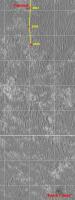
Thanks for the comments but for the time being I'll keep the top part of the map as it is now because (IMO) 1) it gives a sense of scale to the whole trek and 2) the lack of an absolutely known feature like VC would make the map just a route "from nowhere to nowhere".
I *may* reduce it in the future or even make a new one but only if/when it becomes too big to be handled by my home computer and/or graphic tools. |
|
|
|
|
Oct 29 2009, 05:09 PM
Post
#2600
|
|
 Senior Member Group: Members Posts: 1089 Joined: 19-February 05 From: Close to Meudon Observatory in France Member No.: 172 |
Me too : I prefer a global picture, because it shows where we started from. Thanks again for your wonderful work
|
|
|
|
|
Oct 29 2009, 05:57 PM
Post
#2601
|
||
|
Senior Member Group: Moderator Posts: 4279 Joined: 19-April 05 From: .br at .es Member No.: 253 |
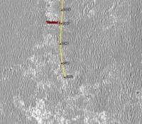
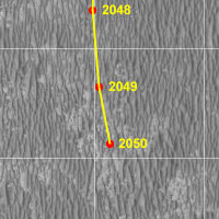
Here's a crop of the map with the latest data from sol 2049.
 Route_Map_Sol2049.kml ( 33.35K )
Number of downloads: 443
Route_Map_Sol2049.kml ( 33.35K )
Number of downloads: 443A mars bar for the first one to guess the distance covered today without looking at the map. 
|
|
|
|
|
|
|
Oct 29 2009, 08:46 PM
Post
#2602
|
|
 Senior Member Group: Members Posts: 1431 Joined: 26-July 08 Member No.: 4270 |
I've seen "70 m" and "steady pace" thrown around earlier so...
70 m? 
-------------------- -- Hungry4info (Sirius_Alpha)
|
|
|
|
|
Oct 30 2009, 09:07 AM
Post
#2603
|
|
|
Senior Member Group: Moderator Posts: 4279 Joined: 19-April 05 From: .br at .es Member No.: 253 |
Bingo.
 Enjoy! |
|
|
|
|
Oct 30 2009, 01:43 PM
Post
#2604
|
|
|
Senior Member Group: Members Posts: 2921 Joined: 14-February 06 From: Very close to the Pyrénées Mountains (France) Member No.: 682 |
I could may be apply to be a Rover driver those days...
 
-------------------- |
|
|
|
|
Oct 31 2009, 12:50 AM
Post
#2605
|
||
|
Member Group: Members Posts: 128 Joined: 28-October 08 From: Boston, MA Member No.: 4469 |
Looks like about 50 meters on sol 2050? As usual, awaiting corroboration from the master...
|
|
|
|
|
|
|
Oct 31 2009, 09:24 AM
Post
#2606
|
|
|
Senior Member Group: Moderator Posts: 4279 Joined: 19-April 05 From: .br at .es Member No.: 253 |
|
|
|
|
|
Oct 31 2009, 01:43 PM
Post
#2607
|
|
 Senior Member Group: Admin Posts: 4763 Joined: 15-March 05 From: Glendale, AZ Member No.: 197 |
I hadn't gone to Google Mars in a while. It looks like a larger strip of HIRISE overlay is needed, or is it just me?
-------------------- If Occam had heard my theory, things would be very different now.
|
|
|
|
|
Oct 31 2009, 01:58 PM
Post
#2608
|
|
 Member Group: Members Posts: 813 Joined: 8-February 04 From: Arabia Terra Member No.: 12 |
QUOTE (ElkGroveDan @ Oct 31 2009, 01:43 PM)  I hadn't gone to Google Mars in a while. It looks like a larger strip of HIRISE overlay is needed, or is it just me? I've created an extension to the HiRISE coverage which you can find here. Edit: ...at least you could, a while back. I think legittorrents may have gone down temporarily. Edit 2: I've added a new tracker. You can now get the torrent here.Edit 3: I spoke too soon! Just seen this message on the tracker: "Le status de moderation de ce torrent l'empeche d'etre actif pour le telechargement. Une enquete est en cours concernant sa legitimite sur freetorrent.fr" As the file is an entirely legitimate one that I made from a public domain image it should be fine. Hopefully they'll approve it. Edit 4: OK this one has GOT to work! Use this!
|
|
|
|
|
Oct 31 2009, 10:23 PM
Post
#2609
|
|
|
Senior Member Group: Moderator Posts: 4279 Joined: 19-April 05 From: .br at .es Member No.: 253 |
Wow, two map updates on the same day! (I was a bit late on the previous one)
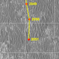 Route_Map_Sol2051.kml ( 33.75K )
Number of downloads: 530
Route_Map_Sol2051.kml ( 33.75K )
Number of downloads: 530 |
|
|
|
|
Nov 1 2009, 02:44 AM
Post
#2610
|
|
 Senior Member Group: Members Posts: 2228 Joined: 1-December 04 From: Marble Falls, Texas, USA Member No.: 116 |
QUOTE (SFJCody @ Oct 31 2009, 07:58 AM) ... Use this! I've been using your original three part set of maps, and they seem to work well for me. Would I find much of an advantage in downloading the new v2 extension? -------------------- ...Tom
I'm not a Space Fan, I'm a Space Exploration Enthusiast. |
|
|
|
|

|
Lo-Fi Version | Time is now: 27th May 2024 - 04:56 AM |
|
RULES AND GUIDELINES Please read the Forum Rules and Guidelines before posting. IMAGE COPYRIGHT |
OPINIONS AND MODERATION Opinions expressed on UnmannedSpaceflight.com are those of the individual posters and do not necessarily reflect the opinions of UnmannedSpaceflight.com or The Planetary Society. The all-volunteer UnmannedSpaceflight.com moderation team is wholly independent of The Planetary Society. The Planetary Society has no influence over decisions made by the UnmannedSpaceflight.com moderators. |
SUPPORT THE FORUM Unmannedspaceflight.com is funded by the Planetary Society. Please consider supporting our work and many other projects by donating to the Society or becoming a member. |
|