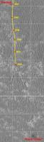
Opportunity Route Map |

  |
Opportunity Route Map |
 Nov 1 2009, 08:01 AM Nov 1 2009, 08:01 AM
Post
#2611
|
|
 Senior Member  Group: Members Posts: 1431 Joined: 26-July 08 Member No.: 4270 |
QUOTE ("Tesheiner") Bingo. Enjoy! Lol woot!Is Google Mars up to date? or updated often? I recently downloaded the programme and Opportunity was one of my first targets of course. From what I saw, it seemed like it was rather behind in updating Opportunity's path. Most notably, I checked after she turned around and headed for Block Island, but Google Mars did not show that. -------------------- -- Hungry4info (Sirius_Alpha)
|
 |
 
|
|
Nov 1 2009, 09:32 AM
Post
#2612
|
|
 Member Group: Members Posts: 813 Joined: 8-February 04 From: Arabia Terra Member No.: 12 |
QUOTE (CosmicRocker @ Nov 1 2009, 02:44 AM)  I've been using your original three part set of maps, and they seem to work well for me. Would I find much of an advantage in downloading the new v2 extension? The original version works well enough. The updated version is in full resolution, although it only incorporates one extra HiRISE image (so far). QUOTE (Hungry4info @ Nov 1 2009, 08:01 AM) it seemed like it was rather behind in updating Opportunity's path. Most notably, I checked after she turned around and headed for Block Island, but Google Mars did not show that. I don't think they've updated Opportunity's path since the first release. That's why Tesheiner's making his Google Mars route map updates. You might also want to download version 1 or version 2 of my additional HiRISE overlays |
|
|
|
|
Nov 1 2009, 12:28 PM
Post
#2613
|
|
|
Senior Member Group: Moderator Posts: 4279 Joined: 19-April 05 From: .br at .es Member No.: 253 |
I saw just one route update after the first release.
In any case I don't blame them; Opportunity's site is just one of hundreds (if not thousands) of interesting places. If they would have to update GE with each and every new image --or path in this case-- whenever they become available, it would be a significant task in terms of effort (and probably $$$). This is a really powerful tool and I believe it's our opportunity (no pun intended) to make use of it with, for instance, my route map and SFJCody's supplementary background. |
|
|
|
|
Nov 3 2009, 09:12 PM
Post
#2614
|
||
|
Senior Member Group: Moderator Posts: 4279 Joined: 19-April 05 From: .br at .es Member No.: 253 |
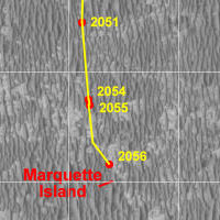
Map update after sol 2054 and another 70m to the wheels.
 Route_Map_Sol2054.kml ( 34.09K )
Number of downloads: 484
Route_Map_Sol2054.kml ( 34.09K )
Number of downloads: 484 |
|
|
|
|
|
|
Nov 5 2009, 09:08 PM
Post
#2615
|
|
|
Senior Member Group: Moderator Posts: 4279 Joined: 19-April 05 From: .br at .es Member No.: 253 |
|
|
|
|
|
Nov 8 2009, 09:27 AM
Post
#2616
|
|
|
Senior Member Group: Moderator Posts: 4279 Joined: 19-April 05 From: .br at .es Member No.: 253 |
|
|
|
|
|
Nov 11 2009, 10:46 AM
Post
#2617
|
|
|
Senior Member Group: Moderator Posts: 4279 Joined: 19-April 05 From: .br at .es Member No.: 253 |
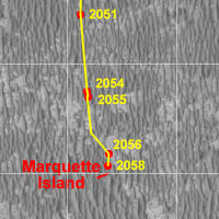
Here's the GE map version for sol 2061. The JPEG map is almost the same as the previous one and I don't want to clutter it too much.
Route_Map_Sol2061.kml ( 34.85K )
Number of downloads: 580 |
|
|
|
|
Nov 13 2009, 09:28 AM
Post
#2618
|
|
|
Senior Member Group: Moderator Posts: 4279 Joined: 19-April 05 From: .br at .es Member No.: 253 |
|
|
|
|
|
Dec 21 2009, 10:48 AM
Post
#2619
|
|||
 Senior Member Group: Moderator Posts: 2262 Joined: 9-February 04 From: Melbourne - Oz Member No.: 16 |
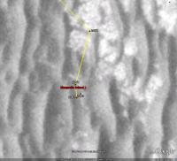
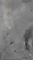
Yestersol was sol B-2100 , time for another map update:
James -------------------- |
||
|
|
|
||
|
Dec 21 2009, 05:09 PM
Post
#2620
|
|
|
Member Group: Members Posts: 362 Joined: 13-April 06 From: Malta Member No.: 741 |
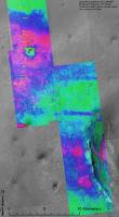
Whats the coloured representing?Topography or geologic units?What does the green area represent?
|
|
|
|
|
Dec 21 2009, 05:27 PM
Post
#2621
|
|
 Senior Member Group: Members Posts: 1887 Joined: 20-November 04 From: Iowa Member No.: 110 |
The height of the ripples: red large ripples, green little ripples.
|
|
|
|
|
Dec 22 2009, 04:51 AM
Post
#2622
|
|
 Member Group: Members Posts: 754 Joined: 9-February 07 Member No.: 1700 |
Every 1000 times I want to say thank you, I feel compelled to post. See you on Sol 3100!!

|
|
|
|
|
Jan 14 2010, 09:35 AM
Post
#2623
|
||
|
Senior Member Group: Moderator Posts: 4279 Joined: 19-April 05 From: .br at .es Member No.: 253 |
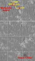
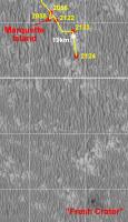
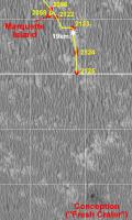
Here's an update to the maps after sols 2122 and 2123.
Route_Map_Sol2123.kml ( 36.48K )
Number of downloads: 411 |
|
|
|
|
|
|
Jan 14 2010, 11:06 PM
Post
#2624
|
||
|
Senior Member Group: Moderator Posts: 4279 Joined: 19-April 05 From: .br at .es Member No.: 253 |
Update after sol 2124, including the 19km mark.
Route_Map_Sol2124.kml ( 36.81K )
Number of downloads: 449 |
|
|
|
|
|
|
Jan 15 2010, 10:28 PM
Post
#2625
|
||
|
Senior Member Group: Moderator Posts: 4279 Joined: 19-April 05 From: .br at .es Member No.: 253 |
Sol 2125.
Route_Map_Sol2125.kml ( 37.05K )
Number of downloads: 412And another milestone; we are 11km south of the landing site. That's the thick horizontal line in the grid. |
|
|
|
|
|
|

|
Lo-Fi Version | Time is now: 27th May 2024 - 05:19 AM |
|
RULES AND GUIDELINES Please read the Forum Rules and Guidelines before posting. IMAGE COPYRIGHT |
OPINIONS AND MODERATION Opinions expressed on UnmannedSpaceflight.com are those of the individual posters and do not necessarily reflect the opinions of UnmannedSpaceflight.com or The Planetary Society. The all-volunteer UnmannedSpaceflight.com moderation team is wholly independent of The Planetary Society. The Planetary Society has no influence over decisions made by the UnmannedSpaceflight.com moderators. |
SUPPORT THE FORUM Unmannedspaceflight.com is funded by the Planetary Society. Please consider supporting our work and many other projects by donating to the Society or becoming a member. |
|