Opportunity Route Map |

  |
Opportunity Route Map |
 Jul 25 2005, 05:57 AM Jul 25 2005, 05:57 AM
Post
#481
|
|
 Chief Assistant  Group: Admin Posts: 1409 Joined: 5-January 05 From: Ierapetra, Greece Member No.: 136 |
Thanks for the updates dilo! Impressive work.
Nico -------------------- photographer, space imagery enthusiast, proud father and partner, and geek.
http://500px.com/sacred-photons & |
 |
 
|
|
Jul 25 2005, 03:25 PM
Post
#482
|
||
|
Senior Member Group: Members Posts: 2835 Joined: 22-April 05 From: Ridderkerk, Netherlands Member No.: 353 |
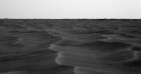
A panoramic view of the Interstate to the south.
Erebus in the background. Taken with the L7 Pancam on Sol 533. jvandriel
Attached thumbnail(s)
|
|
|
|
|
|
|
Jul 25 2005, 06:08 PM
Post
#483
|
|
|
Member Group: Members Posts: 688 Joined: 20-April 05 From: Sweden Member No.: 273 |
Have a look at this:
http://marsrovers.jpl.nasa.gov/gallery/all...HP1607L0M1.HTML I get a strong feeling that what we are seeing here is a thin layer of sand draped over a rather uneven bedrock surface. I wouldn't be in the least surprised if we have a karstic surface underneath. The small crater a few days back could just as easily have been a small doline. tty |
|
|
|
|
Jul 25 2005, 06:15 PM
Post
#484
|
|
 Senior Member Group: Members Posts: 2492 Joined: 15-January 05 From: center Italy Member No.: 150 |
QUOTE (NIX @ Jul 25 2005, 05:57 AM) Thanks for the updates dilo! Impressive work. Nico  Thanks to you, Master!  Beautiful stitch, jvandriel... -------------------- I always think before posting! - Marco -
|
|
|
|
|
Jul 25 2005, 08:06 PM
Post
#485
|
|
|
Senior Member Group: Members Posts: 1636 Joined: 9-May 05 From: Lima, Peru Member No.: 385 |
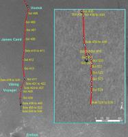
QUOTE (dot.dk @ Jul 24 2005, 07:42 PM) JPL has updated the traverse map for Opportunity  http://marsrover.nasa.gov/mission/tm-opportunity/index.html The best estimation that Oppy reach the hearth of Erberus crater is three weeks from now. Rodolfo |
|
|
|
|
Jul 25 2005, 08:17 PM
Post
#486
|
|
 Senior Member Group: Members Posts: 3419 Joined: 9-February 04 From: Minneapolis, MN, USA Member No.: 15 |
QUOTE (tty @ Jul 25 2005, 01:08 PM) I get a strong feeling that what we are seeing here is a thin layer of sand draped over a rather uneven bedrock surface. I wouldn't be in the least surprised if we have a karstic surface underneath. The small crater a few days back could just as easily have been a small doline. It *may* be karstic -- but I think the simpler answer is that the jumbled bedrock under this sand is the ejecta from Erebus and Terra Nova. They are craters, so they had to have emplaced ejecta blankets when they formed. And we're approaching their rims. Why posit karsts to account for the uneven base of bedrock when we *know* the terrain must have been jumbled by the impacts? -the other Doug -------------------- The trouble ain't that there is too many fools, but that the lightning ain't distributed right. -Mark Twain
|
|
|
|
|
Jul 25 2005, 08:26 PM
Post
#487
|
|
|
Senior Member Group: Members Posts: 1636 Joined: 9-May 05 From: Lima, Peru Member No.: 385 |
QUOTE (tty @ Jul 25 2005, 01:08 PM) Have a look at this: http://marsrovers.jpl.nasa.gov/gallery/all...HP1607L0M1.HTML I get a strong feeling that what we are seeing here is a thin layer of sand draped over a rather uneven bedrock surface. I wouldn't be in the least surprised if we have a karstic surface underneath. The small crater a few days back could just as easily have been a small doline. tty TTy I agree with you, it might be the best explanation about the strange of mini-craters which the other Doug have mentioned. I tought these mini-craters might have caused by: 1) Small meteorite. It might occur but it is not so evident since there is no much debris around mini-crater. I remember that Oppy found a meteorite on the surface close to heatshield without any hole and no debris -very strange case  - -2) A expulsed stone from a nearby volcan. Descarted hypothesis. Not enough momentum to make such a hole. 3) Underground water filtration. Possible hypothesis. The water current might have erosioned the outcroup making a crack to underground. and now the new hypothesis : 4) the hole follows to the strange surface of outcrop under sand. Rodolfo |
|
|
|
|
Jul 25 2005, 11:26 PM
Post
#488
|
|||
|
Senior Member Group: Members Posts: 2492 Joined: 15-January 05 From: center Italy Member No.: 150 |
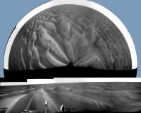
Looking carefully to Sol 533 PanCam images, closest Erebus rim is only 12 pixel (10mrad) below horizon; this should translate in a mere 150m distance!

Meanwhile, this is the stitch+polar projection from Sol531:
-------------------- I always think before posting! - Marco -
|
||
|
|
|
||
|
Jul 26 2005, 12:15 AM
Post
#489
|
|
|
Senior Member Group: Members Posts: 2492 Joined: 15-January 05 From: center Italy Member No.: 150 |
Oops, I made a mistake, using the NavCam resolution figure instead of 0.28mrad/pixel of Pancam.
 So distance is more than 400m, in agreement with last officail route maps. So distance is more than 400m, in agreement with last officail route maps.  ! !
-------------------- I always think before posting! - Marco -
|
|
|
|
| Guest_Sunspot_* |
Jul 26 2005, 01:52 AM
Post
#490
|
|
Guests |
400m? I'm sure we're much closer than that. Remember that map is now about 8 days old.
|
|
|
|
|
Jul 26 2005, 05:23 AM
Post
#491
|
||
|
Senior Member Group: Members Posts: 2492 Joined: 15-January 05 From: center Italy Member No.: 150 |
QUOTE (Sunspot @ Jul 26 2005, 01:52 AM) 400m? I'm sure we're much closer than that. Remember that map is now about 8 days old. You're right... more precisely, from last map
An overestimated distance could arise from slightly elevated Erebus rim  ... in fact, the far rim appear almost on the horizon for the same reason. ... in fact, the far rim appear almost on the horizon for the same reason.
-------------------- I always think before posting! - Marco -
|
|
|
|
|
|
|
Aug 4 2005, 10:06 PM
Post
#492
|
||
|
Senior Member Group: Members Posts: 2492 Joined: 15-January 05 From: center Italy Member No.: 150 |
This is a combination of last 3 days vertical projections of NavCam Panoramas, showing the path over the etched terrain:
From waypoints, movement was: SOL541: 21.9m SOL542: 9.1m (official odometry should be slightly higher, due to slippage and deviations from linear path...) -------------------- I always think before posting! - Marco -
|
|
|
|
|
|
|
Aug 4 2005, 10:20 PM
Post
#493
|
||
|
Founder Group: Chairman Posts: 14432 Joined: 8-February 04 Member No.: 1 |
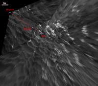
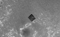
Trying to match up your image, with my old 1m MOC mosaic..
Attached thumbnail(s)
|
|
|
|
|
|
|
Aug 5 2005, 02:11 AM
Post
#494
|
|
|
Senior Member Group: Members Posts: 1276 Joined: 25-November 04 Member No.: 114 |
Dilo that map is amazing!( via_Meridiani.jpg) I hope to see more of those!
|
|
|
|
|
Aug 5 2005, 06:14 AM
Post
#495
|
|
|
Senior Member Group: Members Posts: 2492 Joined: 15-January 05 From: center Italy Member No.: 150 |
QUOTE (Decepticon @ Aug 5 2005, 02:11 AM) Dilo that map is amazing!( via_Meridiani.jpg) I hope to see more of those! You can be sure, Decepticon! stay tuned...
-------------------- I always think before posting! - Marco -
|
|
|
|
|

|
Lo-Fi Version | Time is now: 27th May 2024 - 02:37 PM |
|
RULES AND GUIDELINES Please read the Forum Rules and Guidelines before posting. IMAGE COPYRIGHT |
OPINIONS AND MODERATION Opinions expressed on UnmannedSpaceflight.com are those of the individual posters and do not necessarily reflect the opinions of UnmannedSpaceflight.com or The Planetary Society. The all-volunteer UnmannedSpaceflight.com moderation team is wholly independent of The Planetary Society. The Planetary Society has no influence over decisions made by the UnmannedSpaceflight.com moderators. |
SUPPORT THE FORUM Unmannedspaceflight.com is funded by the Planetary Society. Please consider supporting our work and many other projects by donating to the Society or becoming a member. |
|