Some Statistics for Spirit & Oppy, As the journey continues on Mars |

  |
Some Statistics for Spirit & Oppy, As the journey continues on Mars |
 Mar 26 2010, 02:44 PM Mar 26 2010, 02:44 PM
Post
#91
|
|
 Senior Member  Group: Members Posts: 1084 Joined: 19-February 05 From: Close to Meudon Observatory in France Member No.: 172 |
QUOTE (jamescanvin @ Mar 25 2010, 09:16 PM)  Mark, ...I guess the question is: Is the end-of-mission, the day we broke it, or the day we last heard from it ? James I was just back in France but contacted the following day after we received no downlink from VL1... It's really sol 2245. We all agreed on this Sol date at JPL as the most relevant for the end of mission date : i.e. the last transmission received from VL1 (with latest images and meteorological data from Sol 2238) http://www.unmannedspaceflight.com/index.p...st&p=156850 |
 |
 
|
|
Mar 26 2010, 09:21 PM
Post
#92
|
|
|
Senior Member Group: Members Posts: 2920 Joined: 14-February 06 From: Very close to the Pyrénées Mountains (France) Member No.: 682 |
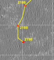
If I understand Eduardo's Oppy's route map, on Sol 2188, Oppy reached the most western point of her whole journey... since she'll rove east from now on.
 -------------------- |
|
|
|
|
Mar 26 2010, 09:48 PM
Post
#93
|
|
 Senior Member Group: Members Posts: 4246 Joined: 17-January 05 Member No.: 152 |
QUOTE (climber @ Mar 26 2010, 10:21 PM) Oppy reached the most western point of her whole journey... Until, that is, she's done with Endeavour and Iazu, and then heads back west to Bopolu and then farther into Miyamoto...  
|
|
|
|
|
Mar 26 2010, 09:57 PM
Post
#94
|
|
|
Senior Member Group: Members Posts: 2920 Joined: 14-February 06 From: Very close to the Pyrénées Mountains (France) Member No.: 682 |
As a coincidence, half a mission ago, on ~sol 1100 she was on her most Eastern point so far, and yes, she's supposed to challenge this very soon.
What about showing your BLACK MAN at Miyamoto for scale, fredk? 
-------------------- |
|
|
|
|
Apr 19 2010, 01:24 PM
Post
#95
|
|
|
Senior Member Group: Members Posts: 2920 Joined: 14-February 06 From: Very close to the Pyrénées Mountains (France) Member No.: 682 |
I checked out the JPL Rover website on the pictures section: for the first time since landing, Oppy shows more Sols than Spirit: 2209 vs 2208
-------------------- |
|
|
|
|
May 8 2010, 03:02 PM
Post
#96
|
||
 Senior Member Group: Members Posts: 2492 Joined: 15-January 05 From: center Italy Member No.: 150 |
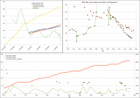
Update:
Attached thumbnail(s)
-------------------- I always think before posting! - Marco -
|
|
|
|
|
|
|
May 10 2010, 11:05 AM
Post
#97
|
|
|
Senior Member Group: Members Posts: 2920 Joined: 14-February 06 From: Very close to the Pyrénées Mountains (France) Member No.: 682 |
Sorry I missed this one 2 weeks ago.
On sol 2218, April 21st 2010, Oppy  from Victoria surpassed Total Spirit mileage. from Victoria surpassed Total Spirit mileage.On previous drive Total distance was 20385m (source Mer website) and since Oppy left Victoria at 12678m, the traverse was 7707m. Total for Spirit is 7730m and Oppy sol 2218 was over 60m (source Eduardo's map). This gives a pretty nice prespective of what has already been accomplished during the traverse. -------------------- |
|
|
|
|
May 10 2010, 10:36 PM
Post
#98
|
|
|
Junior Member Group: Members Posts: 71 Joined: 19-January 10 From: Grimsby, N.E. Lincs, UK Member No.: 5179 |
QUOTE (climber @ May 10 2010, 12:05 PM) This gives a pretty nice prespective of what has already been accomplished during the traverse. I guess this really does give an insight into how you break down a daunting task into small, manageable chunks. 19km in an ageing rover appears impossible - but by taking it day by day the impossible can now be seen in the camera lens, growing larger with every driving sol. By my rough calculations (and please correct me if I'm wrong, Fredk, Eduardo, Stu etc) although she has covered more ground than Spirit since leaving Victoria, Oppy has still only (only!) covered about 7,300 metres, as at sol 2226, of the 19km route to Endeavour crater (that is about 38.4% of the journey - I wish they would still show that bar on the maps!) This just gives one pause for thought on the magnitude of this trek doesn't it? Every day that Oppy drives, whether it be 10 mtrs or 100 just keeps eating away at the task. I'd be interested to know how others visualise this distance. Personally, I do it in two ways. Firstly, I think where I could be if I drove from my house as far as Oppy has travelled? - In my case this would take me into the neighbouring county! Secondly, re the trip to Endeavour, I see the 11,700 mtrs as just over 29 laps of a full size running track still to go. As ever - Go Oppy! Neil |
|
|
|
|
May 11 2010, 04:24 AM
Post
#99
|
|
|
Member Group: Members Posts: 128 Joined: 28-October 08 From: Boston, MA Member No.: 4469 |
I think that these numbers aren't quite right. The 12678m figure quoted by climber probably comes from this JPL update, but that number corresponds to the odometry at the end of sol 1687. That's several long drives into the journey, which began on sol 1683. The same update notes that Opportunity was already 314 meters along at that point, bringing the total odometry to 8021m as of sol 2218.
Personally I still like to think of the journey as having started from Duck Bay. My "records" (I use that term loosely) indicate that that would add another 565 meters. Estimating the last three drives at 75 meters combined, said "records" look like this as of today (sol 2238), stage by stage: CODE STAGE DISTANCE START END TOTAL ODOMETRY Start Duck Bay 11,797.84 meters Stage 0 565.11 m Duck Bay Cape Agulhas 12,362.95 meters Stage 1 1254.38 m Cape Agulhas Santorini 13,617.33 meters Stage 2 1434.11 m Santorini Resolution 15,051.44 meters Stage 3 857.49 m Resolution Kasos 15,908.93 meters Stage 4 803.53 m Kasos Absecon 16,712.46 meters Stage 5 516.17 m Absecon Block Island 17,229.16 meters Stage 6 1698.40 m Block Island Marquette 18,927.56 meters Stage 7 505.28 m Marquette Concepción 19,432.84 meters Stage 8 1238.53 m Concepción 20,671.37 meters TOTAL 8873.53 m |
|
|
|
|
May 11 2010, 10:13 AM
Post
#100
|
|
|
Junior Member Group: Members Posts: 71 Joined: 19-January 10 From: Grimsby, N.E. Lincs, UK Member No.: 5179 |
Thanks Poolio - I'm more than happy to be corrected!
If we take Duck Bay as the starting point as you suggest, are we still looking at a total journey of 19km or do we have an update on that figure as well? Neil |
|
|
|
|
May 11 2010, 01:23 PM
Post
#101
|
|
|
Member Group: Members Posts: 128 Joined: 28-October 08 From: Boston, MA Member No.: 4469 |
I really don't know. I believe that the "official" NASA stance is that the trip to Endeavor started at Cape Agulhas, and the last we've seen from the maps is that the trip from there was estimated at 19km. I'm not suggesting that anyone should adopt my practice of counting from Duck Bay, but if you do, just add another 1/2 km.
Perhaps one of the reasons they stopped putting the bar on the maps is that the total distance is a moving target. Every uncrossable dune and "interesting rock" adds to the total, and it's futile to try and calculate the percentage based on a variable number. So I just like to keep an eye on the horizon and watch the scenery go by. |
|
|
|
|
May 11 2010, 02:04 PM
Post
#102
|
|
|
Senior Member Group: Members Posts: 4246 Joined: 17-January 05 Member No.: 152 |
QUOTE (Poolio @ May 11 2010, 02:23 PM) Perhaps one of the reasons they stopped putting the bar on the maps is that the total distance is a moving target. I don't think they've stopped. The bars are included in the maps from Ohio State University - here's the latest one: http://marsrovers.jpl.nasa.gov/mission/tm-...ty-sol2199.html What's changed is that we're now also getting very regular map updates (basically every drive) from Tim Parker. The OSU updates were never nearly as frequent as Parker's. |
|
|
|
|
May 11 2010, 02:50 PM
Post
#103
|
|
|
Senior Member Group: Members Posts: 2920 Joined: 14-February 06 From: Very close to the Pyrénées Mountains (France) Member No.: 682 |
What I did myself: I used what I thought was the day we left Victoria = on Oct 18th 2008, Sol 1683, at 12678m (and I can't remember now how I "choose" this date) ... and followed this way. I mean, we could discuss departure date but there is no point doing so.
My post was to put Oppy's traverse as a distance perpective to compared to Spirit's. -------------------- |
|
|
|
|
May 11 2010, 05:24 PM
Post
#104
|
|
|
Member Group: Members Posts: 128 Joined: 28-October 08 From: Boston, MA Member No.: 4469 |
Of course. Arguing departure date doesn't get us any closer to Endeavour. The point of your post was well taken, but sometimes I can't help being pedantic. This is a "statistics" thread, after all!
fredk: Thanks for the clarification on the maps. I knew that Tim Parker was driving the recent frequency of map updates, but never understood that the other maps were generated outside of JPL (despite the legend), or that we could still expect to see them from time to time. |
|
|
|
|
May 11 2010, 08:44 PM
Post
#105
|
|
|
Senior Member Group: Members Posts: 2920 Joined: 14-February 06 From: Very close to the Pyrénées Mountains (France) Member No.: 682 |
QUOTE (Poolio @ May 11 2010, 07:24 PM) Of course. Arguing departure date doesn't get us any closer to Endeavour. The point of your post was well taken, but sometimes I can't help being pedantic. This is a "statistics" thread, after all! Agree too!... so, I guess this is THE source...  : http://marsrovers.jpl.nasa.gov/mission/sta...08.html#sol1681 : http://marsrovers.jpl.nasa.gov/mission/sta...08.html#sol1681
-------------------- |
|
|
|
|

|
Lo-Fi Version | Time is now: 27th April 2024 - 01:07 PM |
|
RULES AND GUIDELINES Please read the Forum Rules and Guidelines before posting. IMAGE COPYRIGHT |
OPINIONS AND MODERATION Opinions expressed on UnmannedSpaceflight.com are those of the individual posters and do not necessarily reflect the opinions of UnmannedSpaceflight.com or The Planetary Society. The all-volunteer UnmannedSpaceflight.com moderation team is wholly independent of The Planetary Society. The Planetary Society has no influence over decisions made by the UnmannedSpaceflight.com moderators. |
SUPPORT THE FORUM Unmannedspaceflight.com is funded by the Planetary Society. Please consider supporting our work and many other projects by donating to the Society or becoming a member. |
|