Opportunity Route Map |

  |
Opportunity Route Map |
 Aug 5 2005, 07:57 AM Aug 5 2005, 07:57 AM
Post
#496
|
||
|
Senior Member  Group: Moderator Posts: 4279 Joined: 19-April 05 From: .br at .es Member No.: 253 |
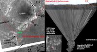
QUOTE (djellison @ Aug 5 2005, 12:20 AM) Trying to match up your image, with my old 1m MOC mosaic..  Doug, I believe Oppy is located just a bit to the left (west); at this point:
I made a similar exercise yesterday to plot the rover position (based on dilo's vertical projections and MOC image R1500822, but plotted on Phil's image - see here: http://www.unmannedspaceflight.com/index.p...indpost&p=16125). Some meters to the east or to the west, it is not a big deal. I hope we have soon an updated route map on the MER webpage. But when trying to plot the rover position, and looking to this very nice MOC image (be careful! the full resolution GIF is about 20MB!), IMHO there shouldn't be too much fanfarre about speeding up now that we are at the etched terrain. Ok, the way to Erebus is clear. But have a look to the way to Victoria. Plenty of rocks (same etched terrain, that's good) *and* dunes. Some of those dunes looks *big* and I fear that it will be like going in a maze. Tesheiner |
|
 |
 
|
|
|
Aug 5 2005, 08:40 AM
Post
#497
|
|
|
Member Group: Members Posts: 713 Joined: 30-March 05 Member No.: 223 |
QUOTE (Tesheiner @ Aug 5 2005, 09:57 AM) IMHO there shouldn't be too much fanfarre about speeding up now that we are at the etched terrain. Ok, the way to Erebus is clear. But have a look to the way to Victoria. Plenty of rocks (same etched terrain, that's good) *and* dunes. Some of those dunes looks *big* and I fear that it will be like going in a maze. Tesheiner yes, it won't going to be much easier than the part from purgatory to Erebus ... but also probably not harder  There are two big points working for us: 1. luckily the dunes run in north-south direction 2. the underlying bedrock in-between the duens seems to be very flat so I'm optimistic that with the new driving technique we could still maintain the 30-meter-per-day average which will be sufficient to reach Victoria within about two months of driving...
|
|
|
|
|
Aug 5 2005, 09:03 AM
Post
#498
|
|
|
Senior Member Group: Moderator Posts: 4279 Joined: 19-April 05 From: .br at .es Member No.: 253 |
The dunes orientation is definitely playing in our behalf.
But note that if we want to stay firmly on bedrock a lot of traversing will be needed. Well, traversing will be needed in any case because Victoria is not exactly southwards but about SSE. When Oppy got stuck, one of the possible reasons was because it was quite steep. Actually, they later drove backwards looking for an easier path. Maybe I'm being pessimistic but assuming that the ripples seen on the MOC image are actually dunes, the way to Victoria is filled with quite "nice" (to not say *big*) ones. Would Oppy be able to traverse or avoid those dunes? I think so, but the pace will be slower. |
|
|
|
|
Aug 6 2005, 05:29 PM
Post
#499
|
|||
 Senior Member Group: Members Posts: 2492 Joined: 15-January 05 From: center Italy Member No.: 150 |
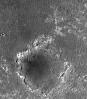
Updated projected route map (added Sol536/539 and last color Panorama!):
I tried to match with MOC image, reducing to the same scale... not easy, but this is best match in my opinion:
If correct, a lot of distance remain to cover: 380m from North Erebus rim! 
-------------------- I always think before posting! - Marco -
|
||
|
|
|
||
|
Aug 6 2005, 05:57 PM
Post
#500
|
|||
|
Member Group: Members Posts: 236 Joined: 21-June 05 Member No.: 417 |
QUOTE (dilo @ Aug 6 2005, 07:29 PM) Updated projected route map (added Sol536/539 and last color Panorama!):
I tried to match with MOC image, reducing to the same scale... not easy, but this is best match in my opinion:
If correct, a lot of distance remain to cover: 380m from North Erebus rim! According to the latest Flight Director's Update, it's 150m
|
||
|
|
|
||
|
Aug 6 2005, 08:49 PM
Post
#501
|
|
|
Member Group: Members Posts: 877 Joined: 7-March 05 From: Switzerland Member No.: 186 |
Hi Dilo, I'm struck your (btw. great) map dont match. Your "pano" seems to cover a larger surface area. Following my guess:
http://www.greuti.ch/oppy/oppy_map_sol545.jpg What do you think, could it be? -------------------- |
|
|
|
|
Aug 6 2005, 09:29 PM
Post
#502
|
||
|
Senior Member Group: Members Posts: 2492 Joined: 15-January 05 From: center Italy Member No.: 150 |
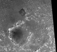
QUOTE (Tman @ Aug 6 2005, 08:49 PM) Hi Dilo, I'm struck your (btw. great) map dont match. Your "pano" seems to cover a larger surface area. Following my guess: http://www.greuti.ch/oppy/oppy_map_sol545.jpg What do you think, could it be? Frankly, dunno... as showed below, if scale of R1500822 MOC image I used is 1.45m/pixel, the red circle has 150m diameter:
Now, if distance from Erebus rim is really 150m, Oppy should now lie in the etched terrain indicated by A, while most of us think is near B (and you too). Alternatively, Flight Director included in the crater definition the etched terrain in A... 
-------------------- I always think before posting! - Marco -
|
|
|
|
|
|
|
Aug 6 2005, 10:04 PM
Post
#503
|
|
 Member Group: Members Posts: 524 Joined: 24-November 04 From: Heraklion, GR. Member No.: 112 |
I would not worry, flight director updates have been wrong/misworded in the past occasionally. I vividly remember the announcement that Oppy was leaving Endurance at some FD update, and that was before Oppy even had reached Wopmay. On the contrary, Oppy stayed inside and worked its way towards Burns Cliff.
|
|
|
|
|
Aug 6 2005, 10:46 PM
Post
#504
|
|
|
Senior Member Group: Members Posts: 2998 Joined: 30-October 04 Member No.: 105 |
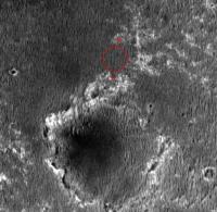
QUOTE Now, if distance from Erebus rim is really 150m, Oppy should now lie in the etched terrain indicated by A, while most of us think is near B (and you too). I agree with Dilo, Oppy has to be at B. She has just now arrived at this first exposure of the Etched Terrain and we didn't see these evaporite windows until a few Sols ago. And if we were at A, the azimuth and distance to the R1 and R2 ridges would be different. The next few Sols will tell. In the meantime, lets have a look at that dark basal unit that is becoming more prevalent. My curiosity is killing me! --Bill -------------------- |
|
|
|
|
Aug 6 2005, 10:47 PM
Post
#505
|
|
 Member Group: Members Posts: 345 Joined: 2-May 05 Member No.: 372 |
QUOTE (Tman @ Aug 6 2005, 04:49 PM) Hi Dilo, I'm struck your (btw. great) map dont match. Your "pano" seems to cover a larger surface area. Following my guess: http://www.greuti.ch/oppy/oppy_map_sol545.jpg What do you think, could it be? Most definitely yes! |
|
|
|
|
Aug 7 2005, 10:16 AM
Post
#506
|
||
|
Senior Member Group: Members Posts: 2492 Joined: 15-January 05 From: center Italy Member No.: 150 |
OK, I played a little bit with images and this is my personal assessment on Rover position:
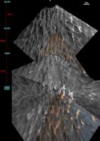
On the right, I extended the last vertical (Pancam) projection and I'm almost sure of last Opportunit position identified in the small MOC inset... On the left portion there are the Phil's Erebus map identifications, re-scaled and re-oriented, based on the R1 ridge azimut and terrain features. All appear reasonable, but scale of this left portion should be about 2.4m/pixel! Interestingly, if we assume the same scale of right portion, the distance from closest "true" Erebus rim becomes 180m, close to the officual value  However, this imply that original MOC image scale of 1.45m/pixel is wrong , and I'm not very confortable with this conclusion... Suggestions? -------------------- I always think before posting! - Marco -
|
|
|
|
|
|
|
Aug 8 2005, 07:57 AM
Post
#507
|
||
|
Senior Member Group: Moderator Posts: 4279 Joined: 19-April 05 From: .br at .es Member No.: 253 |
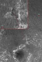
> Suggestions?
Yes. Phil's picture --- the one you (me, and others) used as reference --- is taken from R1500822 but not at the same scale. Here below you can see a selection from the named MOC image, without any re-scaling. If you plot again the two points of that 440m line on this image you'll get 1.4 m/pixel.
Tesheiner |
|
|
|
|
|
|
Aug 8 2005, 10:54 AM
Post
#508
|
||
|
Senior Member Group: Moderator Posts: 4279 Joined: 19-April 05 From: .br at .es Member No.: 253 |
Mmmm,
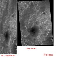
I'm not so confortable with my previous answer because I assumed you measured those 440m on the "wrong" image... After reviewing again the data for image R1500822 on the MSSS site (http://www.msss.com/moc_gallery/r10_r15/im...5/R1500822.html), I have found the following. Our assumption about 1.45 m/pixel for that image comes from the parameter: "Scaled pixel width: 1.45 meters" But R1500822 has actually two versions, one map-projected and another not. The "map-projected" version is the nice one we all have seen here and on another places. But those 1.45 m/pix refers to the NOT map-projected image i.e. the "raw" picture, and is actually the *horizontal* resolution of the picture. The vertical resolution is 1.45 * 0.43 (pixel aspect ratio) = 0.6235 m/pix. The map-projected image may have a different scale. (edited to include reference picture)
|
|
|
|
|
|
|
Aug 8 2005, 12:06 PM
Post
#509
|
|||
|
Member Group: Members Posts: 524 Joined: 24-November 04 From: Heraklion, GR. Member No.: 112 |
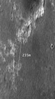
I downloaded the raw R1500822 image from the MSSS site and cropped the interesting part. This image has a resolution of 1.445m/pixel (width) and 0.625m/pixel (height).
The length of the white line (I tried to copy the 440m line in dilo's image above in the thread) comes out as 235m. So, the 150m distance from Erebus mentioned by the flight director must mean the closest largest bright outcrop in the direction of the white line. PS. Edited to attach a "1m/pixel in both directions" version of the image.
Attached thumbnail(s)
|
||
|
|
|
||
|
Aug 8 2005, 12:43 PM
Post
#510
|
|
|
Founder Group: Chairman Posts: 14432 Joined: 8-February 04 Member No.: 1 |
The raw (not projected) images show the huge vertical exageration of CPROTO - but the projected images are at the resolution specificed in both dimensions
Doug |
|
|
|
|

|
Lo-Fi Version | Time is now: 27th May 2024 - 06:46 AM |
|
RULES AND GUIDELINES Please read the Forum Rules and Guidelines before posting. IMAGE COPYRIGHT |
OPINIONS AND MODERATION Opinions expressed on UnmannedSpaceflight.com are those of the individual posters and do not necessarily reflect the opinions of UnmannedSpaceflight.com or The Planetary Society. The all-volunteer UnmannedSpaceflight.com moderation team is wholly independent of The Planetary Society. The Planetary Society has no influence over decisions made by the UnmannedSpaceflight.com moderators. |
SUPPORT THE FORUM Unmannedspaceflight.com is funded by the Planetary Society. Please consider supporting our work and many other projects by donating to the Society or becoming a member. |
|