From Cambridge Bay to the "parking lot" |

  |
From Cambridge Bay to the "parking lot" |
 Oct 6 2010, 08:13 AM Oct 6 2010, 08:13 AM
Post
#301
|
|
|
Senior Member  Group: Moderator Posts: 4279 Joined: 19-April 05 From: .br at .es Member No.: 253 |
We're still 300m from that, so it might be some other nearby feature.
|
 |
 
|
|
Oct 6 2010, 12:07 PM
Post
#302
|
|
|
Member Group: Members Posts: 128 Joined: 28-October 08 From: Boston, MA Member No.: 4469 |
Bill: Unusual drive direction...
alan: Interesting feature about 400 meters to the ENE EGD: ..and and NOT a depression, in which case it'll be a long time before we go anywhere. Floyd: ...looks darker and a different texture from the surrounding outcrop. Okay, I'm a bit slow on the uptake here. You all seem to have some implicit understanding of what's coming up. Change of direction and a possible lengthy stop... it must be good. Are we talking about a dried water feature, possibly an ancient lake or river bed? Perhaps our first encounter with hydrated rocks or clays? |
|
|
|
|
Oct 6 2010, 03:08 PM
Post
#303
|
|
 Senior Member Group: Members Posts: 4247 Joined: 17-January 05 Member No.: 152 |
Well, the northwards move on 2381 could mean they want to have a look at that feature. Santa Maria is still a few hundred metres south of us, and to my eye there's no obvious obstacles along a direct ESE route towards Santa Maria.
On the other hand, it may just be that they want to follow the bedrock highway stretching to our ENE for more than a kilometre, before getting onto the flat sand for the final stretch to Santa Maria. Bedrock is easy driving. |
|
|
|
|
Oct 6 2010, 05:24 PM
Post
#304
|
||
 Senior Member Group: Members Posts: 1887 Joined: 20-November 04 From: Iowa Member No.: 110 |
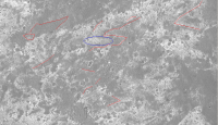
What I think I'm seeing is a zigzag contact where the east side is slightly elevated (about the height of the local ripples) exposing the layers. There are a number of other similar appearing features (linear breaks between pavement and dunes) visible in the area linear I've outlined in the attached image. Most of these I suspect the contact has been covered by the ripples. I pointed out the zigzag feature earlier because I thought it was the next target because it and the V-shape to the east of it appear to be the most likely spots to find an exposure that hasn't been covered by the ripples. Don't know what's going on with the mottled area that I've circled, maybe its slightly lower and this has interfered with the formation of the N-S ripples.
|
|
|
|
|
|
|
Oct 6 2010, 06:18 PM
Post
#305
|
|
|
Member Group: Members Posts: 910 Joined: 4-September 06 From: Boston Member No.: 1102 |
The area circled seems brown compared to normal bedrock in your color image. (alan, you must have flipped or rotated the color image as it is oriented the same as all the black and whites) I'm guessing there is something interesting about the exposed bedrock, but we will see.
Seems the image pipeline is busted somewhere (Exploratorium and JPL sites have not updated in the past few days) but I infer from map updates and other information posted on UMSF that information from Oppy is getting to earth just fine.  Hay Doug, now that you are at JPL, can you give the pipe a kick? -------------------- |
|
|
|
|
Oct 6 2010, 08:20 PM
Post
#306
|
|
|
Member Group: Members Posts: 128 Joined: 28-October 08 From: Boston, MA Member No.: 4469 |
Thanks everyone for the clarification. Looking forward to what we see when we get there.
|
|
|
|
|
Oct 7 2010, 08:01 PM
Post
#307
|
||
|
Senior Member Group: Members Posts: 1887 Joined: 20-November 04 From: Iowa Member No.: 110 |
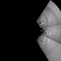
Quick stitch of drive direction stamps images from 2382.
|
|
|
|
|
|
|
Oct 7 2010, 08:32 PM
Post
#308
|
||
|
Senior Member Group: Moderator Posts: 4279 Joined: 19-April 05 From: .br at .es Member No.: 253 |
I'm wondering where's that thread talking on "You know you're an UMSF hardcore" (or somethink like that)...
 I did a similar one some time ago to get this polar view and try to use it to fine tune that sol's position on the route map.
Data from sol 2383 drive is flowing down. Something like +60m eastward. |
|
|
|
|
|
|
Oct 9 2010, 11:55 AM
Post
#309
|
|
|
Senior Member Group: Members Posts: 2921 Joined: 14-February 06 From: Very close to the Pyrénées Mountains (France) Member No.: 682 |
In case you missed it, a twitter from Scott 14 hours ago: "No rover driving today: flash is too full; nowhere to store the data we'd generate. Gonna downlink and delete a bunch over the weekend".
Can't remember this occured for a long time. -------------------- |
|
|
|
|
Oct 9 2010, 02:51 PM
Post
#310
|
|
|
Member Group: Members Posts: 128 Joined: 28-October 08 From: Boston, MA Member No.: 4469 |
It's been a long time since they've done autonav. I'll bet that a lot of those data are mid-drive navcam (and some rhazcam) images for autonav purposes. It's been just about two months since they started autonav so maybe those images have piled up.
|
|
|
|
|
Oct 11 2010, 01:55 AM
Post
#311
|
|
 Member Group: Members Posts: 813 Joined: 8-February 04 From: Arabia Terra Member No.: 12 |
Looks like we have a likely arrival date:
http://science.nasa.gov/science-news/scien...2010/07oct_yss/ QUOTE Sometime in mid-2012, Opportunity will reach Endeavour's lip and look
over the edge deeper into the heart of Mars than any previous robotic explorer. The only thing more marvelous than the view will be the rover itself. Originally designed to travel no more than 0.6 miles, Opportunity's rest stop at Endeavour will put it just miles away from finishing the kind of epic Greek run that athletes on Earth can only dream about. |
|
|
|
|
Oct 11 2010, 02:29 AM
Post
#312
|
|
 Member Group: Members Posts: 754 Joined: 9-February 07 Member No.: 1700 |
Does Oppy use less juice rolling downhill, as it is towards Endeavour?
|
|
|
|
|
Oct 11 2010, 03:40 AM
Post
#313
|
|
|
Senior Member Group: Members Posts: 4247 Joined: 17-January 05 Member No.: 152 |
The slope down to Endeavour will still be very subtle (a degree or less on average), so I'd expect the rolling friction to dominate.
I'm surprized anyone gave them a date as specific as "mid 2012", considering how unpredictable these things are... |
|
|
|
|
Oct 11 2010, 05:08 AM
Post
#314
|
|
|
Member Group: Members Posts: 754 Joined: 9-February 07 Member No.: 1700 |
As Oppy rolls downhill, would she spend some more energy stopping than accelerating? It is in this case so gradual as to not be an issue, but what about steeper slopes or drop-offs? Was that issue covered in the Victoria threads? I'll check!
|
|
|
|
|
Oct 11 2010, 07:15 AM
Post
#315
|
|
 The Poet Dude Group: Moderator Posts: 5551 Joined: 15-March 04 From: Kendal, Cumbria, UK Member No.: 60 |
QUOTE (fredk @ Oct 11 2010, 04:40 AM)  I'm surprized anyone gave them a date as specific as "mid 2012", considering how unpredictable these things are... That must be someone adding 2 and 2 and getting 5, cos surely they can't know an arrival time yet; that will depend on so many variables - how long Oppy stops at Santa Maria, what she finds there, how many other distractions she encounters along the way, how many tech faults crop up, etc etc. I really wish people wouldn't fix dates to these things, there's no point, and I'm surprised someone at NASA has done it. But someone must have given them that date, so...  And although I can't wait to see it, I'm also wondering just how 'marvelous' the view will be across and into the crater once we get there. I mean, it's not a pit, or an abyss ( © ustrax ), is it? The hills on t'other side will look amazing, for sure, but we won't get the same impression of depth as we did at Victoria, will we? It'll be a mega wide-angle view, won't it? But I suppose it makes sense in the context of the "Year of the Solar System" press release - linking Oppy and Curiosity together like that, a clever move, "the torch being passed" and all that... 
-------------------- |
|
|
|
|

|
Lo-Fi Version | Time is now: 26th May 2024 - 10:27 AM |
|
RULES AND GUIDELINES Please read the Forum Rules and Guidelines before posting. IMAGE COPYRIGHT |
OPINIONS AND MODERATION Opinions expressed on UnmannedSpaceflight.com are those of the individual posters and do not necessarily reflect the opinions of UnmannedSpaceflight.com or The Planetary Society. The all-volunteer UnmannedSpaceflight.com moderation team is wholly independent of The Planetary Society. The Planetary Society has no influence over decisions made by the UnmannedSpaceflight.com moderators. |
SUPPORT THE FORUM Unmannedspaceflight.com is funded by the Planetary Society. Please consider supporting our work and many other projects by donating to the Society or becoming a member. |
|