From Cambridge Bay to the "parking lot" |

  |
From Cambridge Bay to the "parking lot" |
 Oct 28 2010, 06:52 AM Oct 28 2010, 06:52 AM
Post
#451
|
||
 The Poet Dude  Group: Moderator Posts: 5551 Joined: 15-March 04 From: Kendal, Cumbria, UK Member No.: 60 |
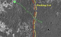
I think you're right. We need another couple of drives before we get to the real "Parking Lot". Until then we'll still be in a ripple field... kind of the grassy area where people dump their trolleys that borders the Parking Lot

-------------------- |
|
 |
 
|
|
|
Oct 28 2010, 12:58 PM
Post
#452
|
||
|
Member Group: Members Posts: 877 Joined: 7-March 05 From: Switzerland Member No.: 186 |
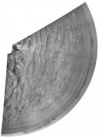
QUOTE (ngunn @ Oct 27 2010, 08:43 PM)  I've also been musing on why 'leftmost' doesn't show on the HiRise. ('Rightmost' if a little more distant may do so - I'm still hoping for a TMAN fix to check that.) With the same measuring I used there I get the 'Rightmost' about 100 meters farther, but for the later sols it is definitely no longer possible to hit these spots. It seems to work fine (on sol 2402) with a fixed feature at the far horizon... as for the used map above and additionally for the "little" crater at 124 degrees in this image (from ESP_012820_1780_RED.abrowse):
-------------------- |
|
|
|
|
|
|
Oct 28 2010, 01:15 PM
Post
#453
|
||
|
Senior Member Group: Members Posts: 3516 Joined: 4-November 05 From: North Wales Member No.: 542 |
FWIW my latest attempt to identify Santa Maria:
Attached thumbnail(s)
|
|
|
|
|
|
|
Oct 28 2010, 02:54 PM
Post
#454
|
|
|
Member Group: Members Posts: 507 Joined: 10-September 08 Member No.: 4338 |
QUOTE (Stu @ Oct 27 2010, 10:52 PM) ... the real "Parking Lot". Looking at Stu's image, it seems one can still dimly see ripples beneath the smooth "parking lot" surface. Maybe this is an illusion, but it suggests that the parking lot level has been superimposed on a pre-existing rippled surface. Can we infer anything about the surface formation process from this? |
|
|
|
|
Oct 28 2010, 03:20 PM
Post
#455
|
||
 Senior Member Group: Members Posts: 4247 Joined: 17-January 05 Member No.: 152 |
QUOTE (Stu @ Oct 28 2010, 07:52 AM) I think you're right. We need another couple of drives before we get to the real "Parking Lot".
I agree. I make our 2403 position to be just to the SW of where you've plotted it, Stu. The roughly 5-metre crater in that direction is just visible on the far right of this hazcam view: http://qt.exploratorium.edu/mars/opportuni...0M1.JPG?sol2403 And here's the navcam view east showing one of the last patches of ripples we'll encounter: http://qt.exploratorium.edu/mars/opportuni...0M1.JPG?sol2403 Edit: Btw, I still prefer "tarmac" to "parking lot", since you either park or drive very slowly in a parking lot, but you move quickly across the tarmac! 
|
|
|
|
|
|
|
Oct 28 2010, 04:56 PM
Post
#456
|
|
|
Member Group: Senior Member Posts: 136 Joined: 8-August 06 Member No.: 1022 |
QUOTE (Phil Stooke @ Oct 27 2010, 09:03 AM) Fred has already posted some stretched images, but here is the full span of this panorama with a ten times stretch. The whole view is opening up beautifully. I'd like to see it with more oblique lighting one day... the appearance will change quite a lot with different lighting. Phil [attachment=22869:pan_sol_...tch_post.jpg] Phil: This is neat. Like many of you have been suggesting, I *think* that Santa Maria is starting to poke up as the two dark patches at the left of your stretched pan. We should know soon enough... ...but I'm just starting mourning having left the largest expanse of outcrop we've ever seen (possibly more than we'll ever see). -Tim. |
|
|
|
|
Oct 28 2010, 08:54 PM
Post
#457
|
||
|
Senior Member Group: Members Posts: 4247 Joined: 17-January 05 Member No.: 152 |
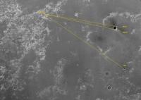
Stereo view of little crater near us on 2403, with really big crater Iazu in the background:
|
|
|
|
|
|
|
Oct 28 2010, 11:53 PM
Post
#458
|
||
|
Solar System Cartographer Group: Members Posts: 10168 Joined: 5-April 05 From: Canada Member No.: 227 |
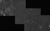
This is only very rough, but shows where we are on the edge of the smoother region. This is from the navcams.
Phil
-------------------- ... because the Solar System ain't gonna map itself.
Also to be found posting similar content on https://mastodon.social/@PhilStooke Maps for download (free PD: https://upload.wikimedia.org/wikipedia/comm...Cartography.pdf NOTE: everything created by me which I post on UMSF is considered to be in the public domain (NOT CC, public domain) |
|
|
|
|
|
|
Oct 29 2010, 05:52 AM
Post
#459
|
|
|
Senior Member Group: Members Posts: 1044 Joined: 17-February 09 Member No.: 4605 |
QUOTE (marsophile @ Oct 28 2010, 03:54 PM) Looking at Stu's image, it seems one can still dimly see ripples beneath the smooth "parking lot" surface. And immediately after the brief smpooth area imaged by Stu, we seem encounter further ripples. This 'tarmac' edge seems to be a localised feature or outlier rather than the true tarmac edge. |
|
|
|
|
Oct 29 2010, 07:41 AM
Post
#460
|
||
|
The Poet Dude Group: Moderator Posts: 5551 Joined: 15-March 04 From: Kendal, Cumbria, UK Member No.: 60 |
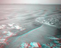
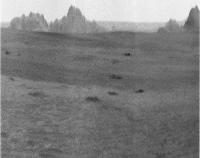
You're right, Serpens: close-up of the terrain en-route to the next waypoint crater... definitely going to roll over a much flatter swathe of ground on the way to it...
-------------------- |
|
|
|
|
|
|
Oct 29 2010, 09:10 AM
Post
#461
|
|
|
Senior Member Group: Members Posts: 1044 Joined: 17-February 09 Member No.: 4605 |
As Marsophile pointed out, there seems to be an underlying ripple structure. There are also a number a craters that are seemingly of the same age in the flattened area boundary. Possibly an airburst which generated sufficient overpressure to flatten out the ripples?
|
|
|
|
|
Oct 29 2010, 09:27 AM
Post
#462
|
|
 Senior Member Group: Members Posts: 1431 Joined: 26-July 08 Member No.: 4270 |
Would the ripples build back up over the surface there? (How long does it take these ripples to form?)
-------------------- -- Hungry4info (Sirius_Alpha)
|
|
|
|
|
Oct 29 2010, 01:39 PM
Post
#463
|
|
|
Solar System Cartographer Group: Members Posts: 10168 Joined: 5-April 05 From: Canada Member No.: 227 |
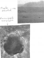
They would build up again... but never mind. These are tiny little ripples, and those HiRISE images, very nice though they are, have had to be extremely contrast-enhanced to show anything. Latest images show this is a great place for driving.
Phil -------------------- ... because the Solar System ain't gonna map itself.
Also to be found posting similar content on https://mastodon.social/@PhilStooke Maps for download (free PD: https://upload.wikimedia.org/wikipedia/comm...Cartography.pdf NOTE: everything created by me which I post on UMSF is considered to be in the public domain (NOT CC, public domain) |
|
|
|
|
Oct 29 2010, 01:44 PM
Post
#464
|
|
|
The Poet Dude Group: Moderator Posts: 5551 Joined: 15-March 04 From: Kendal, Cumbria, UK Member No.: 60 |
You're right Phil, I had to boost the contrast up to "OMG!!!" to show the differences between the neighbouring terrain types. All good driving ground.
-------------------- |
|
|
|
|
Oct 29 2010, 02:00 PM
Post
#465
|
|||
|
Solar System Cartographer Group: Members Posts: 10168 Joined: 5-April 05 From: Canada Member No.: 227 |
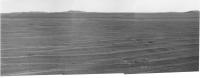
Here's the current pancam panorama and a stretched version of the more distant part of it. We can start to map out the various small craters on views like this.
Phil
-------------------- ... because the Solar System ain't gonna map itself.
Also to be found posting similar content on https://mastodon.social/@PhilStooke Maps for download (free PD: https://upload.wikimedia.org/wikipedia/comm...Cartography.pdf NOTE: everything created by me which I post on UMSF is considered to be in the public domain (NOT CC, public domain) |
||
|
|
|
||
|

|
Lo-Fi Version | Time is now: 26th May 2024 - 10:51 AM |
|
RULES AND GUIDELINES Please read the Forum Rules and Guidelines before posting. IMAGE COPYRIGHT |
OPINIONS AND MODERATION Opinions expressed on UnmannedSpaceflight.com are those of the individual posters and do not necessarily reflect the opinions of UnmannedSpaceflight.com or The Planetary Society. The all-volunteer UnmannedSpaceflight.com moderation team is wholly independent of The Planetary Society. The Planetary Society has no influence over decisions made by the UnmannedSpaceflight.com moderators. |
SUPPORT THE FORUM Unmannedspaceflight.com is funded by the Planetary Society. Please consider supporting our work and many other projects by donating to the Society or becoming a member. |
|