Opportunity Route Map |

  |
Opportunity Route Map |
 Aug 8 2005, 02:13 PM Aug 8 2005, 02:13 PM
Post
#511
|
||
|
Senior Member  Group: Moderator Posts: 4279 Joined: 19-April 05 From: .br at .es Member No.: 253 |
Yes, but which is the resolution of that image?
Take this picture (
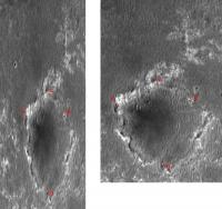
The distance between points A-B in the non-projected picture is 2 x 105 pixels @ 1.45 m/pix = 304.5 meters. On the map-projected picture this distance is about 2 x 199 pixels, which gives us an image scale of 0.765 m/pix (for the full resolution picture). Similar exercise for C-D: not projected: 2 x 262 pix. @ 1.45 * 0.43 m/pix = 326.7 m projected: 2 x 221 pix ==> 0.74 m/pix The net result is that the scale of R1500822 is about 0.75 m/pix. ... or there is something wrong on all this bunch of numbers. :-) |
|
 |
 
|
|
|
Aug 8 2005, 02:55 PM
Post
#512
|
|
|
Founder Group: Chairman Posts: 14432 Joined: 8-February 04 Member No.: 1 |
The odd thing is - the 0.7something m/pixel is actually a figure mentioned if you stumble across that MOC images via the PDS imaging node instead of straight thru the MSSS site.
http://ida.wr.usgs.gov/html/regionsk/07s007.htm http://ida.wr.usgs.gov/html/r15001/r1500169.html http://ida.wr.usgs.gov/html/r15008/r1500822.html Doug |
|
|
|
|
Aug 9 2005, 08:18 PM
Post
#513
|
|
 Senior Member Group: Members Posts: 2492 Joined: 15-January 05 From: center Italy Member No.: 150 |
Thanks to all for great contribution!
Now I'm suspecting that Tesheiner hypothesis is right... they should introduce a more clear indication of scale (a ruler?) in each image, or a clear help on this item. -------------------- I always think before posting! - Marco -
|
|
|
|
|
Aug 9 2005, 09:42 PM
Post
#514
|
|
 Member Group: Members Posts: 524 Joined: 24-November 04 From: Heraklion, GR. Member No.: 112 |
I told you the flight director was messing with us
 "Opportunity is still about about 50 meters (164 feet) north of the "Erebus highway" -- an area the team suspects to be highly populated with outcrop and perhaps easier to navigate. Opportunity is roughly 185 to 200 meters (607 to 656 feet) north of Erebus crater, the next large crater Opportunity will encounter." From the latest JPL update: http://marsrovers.jpl.nasa.gov/mission/status.html |
|
|
|
|
Aug 9 2005, 10:59 PM
Post
#515
|
|
|
Senior Member Group: Members Posts: 1636 Joined: 9-May 05 From: Lima, Peru Member No.: 385 |
QUOTE (Tesheiner @ Aug 8 2005, 09:13 AM) The distance between points A-B in the non-projected picture is 2 x 105 pixels @ 1.45 m/pix = 304.5 meters. On the map-projected picture this distance is about 2 x 199 pixels, which gives us an image scale of 0.765 m/pix (for the full resolution picture).  Hello Tesheiner, I cannot figure out about pixels. Are these pixeles from the picture. I suspect that each pixel is a very small point from the picture? After, translating it that each ones measures an distance of as an example, 0.765 meters? Rodolfo |
|
|
|
|
Aug 10 2005, 05:26 AM
Post
#516
|
|
 Senior Member Group: Members Posts: 2228 Joined: 1-December 04 From: Marble Falls, Texas, USA Member No.: 116 |
This apparently is the "Ice Cream Cone?"
http://marsrovers.jpl.nasa.gov/gallery/all...0P0703L0M1.HTML -------------------- ...Tom
I'm not a Space Fan, I'm a Space Exploration Enthusiast. |
|
|
|
|
Aug 10 2005, 07:09 AM
Post
#517
|
|
|
Senior Member Group: Moderator Posts: 4279 Joined: 19-April 05 From: .br at .es Member No.: 253 |
QUOTE (RNeuhaus @ Aug 10 2005, 12:59 AM) Hello Tesheiner, I cannot figure out about pixels. Are these pixeles from the picture. I suspect that each pixel is a very small point from the picture? After, translating it that each ones measures an distance of as an example, 0.765 meters? Be careful. 0.765 is the calculated scale/resolution of the full-scale image R01500822. The example attached to my previous post is at half-scale - that's why you have those "2 x ..." on the equations. If you want to calculate distances based on that scale parameter (and assuming it is correct ) you should use the map-projected images posted here (http://www.msss.com/moc_gallery/r10_r15/im...5/R1500822.html).In case you want to do that on my example picture you should use 1.53 m/pix (2 x 0.765). |
|
|
|
|
Aug 10 2005, 02:20 PM
Post
#518
|
|
|
Senior Member Group: Members Posts: 1636 Joined: 9-May 05 From: Lima, Peru Member No.: 385 |
QUOTE (CosmicRocker @ Aug 10 2005, 12:26 AM) This apparently is the "Ice Cream Cone?" http://marsrovers.jpl.nasa.gov/gallery/all...0P0703L0M1.HTML Yes it looks like that someone, maybe Oppy has a hidden ice cream, has spilt the ice cream over these dunes. However, what I am seeing it is of the other perspective. It looks like that a previous lake was drained and left the floor full of cracks due to the process of draing. After a long period of time, the land became petrified. Later, came another flow of water and remained for a while and continues the same draining process. Every time the water comes by that land, creates a new layer of outcrop. Rodolfo |
|
|
|
|
Aug 11 2005, 11:21 AM
Post
#519
|
||
|
Senior Member Group: Moderator Posts: 4279 Joined: 19-April 05 From: .br at .es Member No.: 253 |
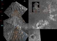
I'm still amazed about how easy is to pick those rock outcrops from Dilo's vertical projection (continue updating it, please!
) and map them on the high-res MOC images...
|
|
|
|
|
|
|
Aug 11 2005, 11:49 AM
Post
#520
|
||
 Member Group: Members Posts: 362 Joined: 12-June 05 From: Kiama, Australia Member No.: 409 |
QUOTE (Tesheiner @ Aug 11 2005, 10:21 PM) I'm still amazed about how easy is to pick those rock outcrops from Dilo's vertical projection (continue updating it, please! ) and map them on the high-res MOC images...
This is an impressive piece of work, Thanks for the effort. |
|
|
|
|
|
|
Aug 12 2005, 10:00 AM
Post
#521
|
||
 Member Group: Members Posts: 562 Joined: 29-March 05 Member No.: 221 |
QUOTE (Tesheiner @ Aug 11 2005, 12:21 PM) I'm still amazed about how easy is to pick those rock outcrops from Dilo's vertical projection
Thanks for that, it makes visualisation of the relationship between the scales of the MOC images and the vertical projections really clear. Unification of different scale imagery like this is great. I now know what the etched terrain is like and can mentally colourise the MOC image and visualise the scale of the rover in the satalite imagery far better than i could yesterday. I suppose someone at JPL is putting together contiguous vertical projections of all the ground covered. I have seen the little tiny squres of this on done on the route maps but not good big images like Dilo's. It does suggest an awesome project to combine all the suitable images into a vertical projection of the route covered. It would be a heck of a magic carpet ride. Dilo you've probably answerd this already but what is the virtual hight you are projecting the images from and does it differ from nav to pancam?. Doug feel free to move this post to the imagery query section if neccessary. |
|
|
|
|
|
|
Aug 12 2005, 10:26 AM
Post
#522
|
|
|
Member Group: Members Posts: 562 Joined: 29-March 05 Member No.: 221 |
Aaaaaarrgggggggg* powers of ten someone please.
With the remapped vertical projections dilos doing and the microscopic imager there is now the scope for a genuine continous zoom from ground-based mars as 'red dot' telescope imagery/HST/viking full disk image all the way throught the MOC images, dilos vertical projections, pancam close ups to the MI images of the blueberries. It'd be a hell of an ani-gif or QT movie. *frustration at lack of skills i'm to busy to learn whilst writing up my dissertation. |
|
|
|
|
Aug 12 2005, 01:37 PM
Post
#523
|
|
 Member Group: Members Posts: 753 Joined: 23-October 04 From: Greensboro, NC USA Member No.: 103 |
Reminds me of comedian Steven Wright: "I have a full-scale map of the US. I don't know where to put it."
-------------------- Jonathan Ward
Manning the LCC at http://www.apollolaunchcontrol.com |
|
|
|
|
Aug 12 2005, 01:59 PM
Post
#524
|
|
 Administrator Group: Admin Posts: 5172 Joined: 4-August 05 From: Pasadena, CA, USA, Earth Member No.: 454 |
QUOTE (paxdan @ Aug 12 2005, 03:26 AM) Aaaaaarrgggggggg* powers of ten someone please. With the remapped vertical projections dilos doing and the microscopic imager there is now the scope for a genuine continous zoom from ground-based mars as 'red dot' telescope imagery/HST/viking full disk image all the way throught the MOC images, dilos vertical projections, pancam close ups to the MI images of the blueberries. Oooh -- great idea! Someone do it, please! Emily -------------------- My website - My Patreon - @elakdawalla on Twitter - Please support unmannedspaceflight.com by donating here.
|
|
|
|
|
Aug 12 2005, 04:59 PM
Post
#525
|
|
 Member Group: Members Posts: 356 Joined: 12-March 05 Member No.: 190 |
|
|
|
|
|

|
Lo-Fi Version | Time is now: 28th May 2024 - 04:12 AM |
|
RULES AND GUIDELINES Please read the Forum Rules and Guidelines before posting. IMAGE COPYRIGHT |
OPINIONS AND MODERATION Opinions expressed on UnmannedSpaceflight.com are those of the individual posters and do not necessarily reflect the opinions of UnmannedSpaceflight.com or The Planetary Society. The all-volunteer UnmannedSpaceflight.com moderation team is wholly independent of The Planetary Society. The Planetary Society has no influence over decisions made by the UnmannedSpaceflight.com moderators. |
SUPPORT THE FORUM Unmannedspaceflight.com is funded by the Planetary Society. Please consider supporting our work and many other projects by donating to the Society or becoming a member. |
|