Post Conjunction: Santa Maria to Cape York, The Journey to 'Spirit Point' |

  |
Post Conjunction: Santa Maria to Cape York, The Journey to 'Spirit Point' |
 Apr 3 2011, 11:31 PM Apr 3 2011, 11:31 PM
Post
#121
|
||
 The Poet Dude  Group: Moderator Posts: 5551 Joined: 15-March 04 From: Kendal, Cumbria, UK Member No.: 60 |
We've seen something like that before...

-------------------- |
|
 |
 
|
|
|
Apr 4 2011, 12:29 AM
Post
#122
|
|
|
Merciless Robot Group: Admin Posts: 8783 Joined: 8-December 05 From: Los Angeles Member No.: 602 |
 However, in sharp contrast, Big Rock requests that you call it "Daddy"... -------------------- A few will take this knowledge and use this power of a dream realized as a force for change, an impetus for further discovery to make less ancient dreams real.
|
|
|
|
|
Apr 4 2011, 04:28 PM
Post
#123
|
|
|
The Poet Dude Group: Moderator Posts: 5551 Joined: 15-March 04 From: Kendal, Cumbria, UK Member No.: 60 |
Large 3D view of the road ahead for Oppy... liking the misty hills on the horizon and the countless small stones strewn over the ground...
http://twitpic.com/4gxhzi/full -------------------- |
|
|
|
|
Apr 5 2011, 10:49 AM
Post
#124
|
||
|
The Poet Dude Group: Moderator Posts: 5551 Joined: 15-March 04 From: Kendal, Cumbria, UK Member No.: 60 |
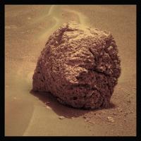
Slightly more realistic view of our big ugly crumbling friend...
(what is its real name? I'm a bit confused, I'll be honest...) -------------------- |
|
|
|
|
|
|
Apr 5 2011, 10:57 AM
Post
#125
|
|
 Senior Member Group: Moderator Posts: 2262 Joined: 9-February 04 From: Melbourne - Oz Member No.: 16 |
QUOTE (Stu @ Apr 5 2011, 11:49 AM)  what is its real name? Bagua -------------------- |
|
|
|
|
Apr 5 2011, 11:17 AM
Post
#126
|
|
|
The Poet Dude Group: Moderator Posts: 5551 Joined: 15-March 04 From: Kendal, Cumbria, UK Member No.: 60 |
Thanks, James.
-------------------- |
|
|
|
|
Apr 5 2011, 03:13 PM
Post
#127
|
||
 Senior Member Group: Members Posts: 4246 Joined: 17-January 05 Member No.: 152 |
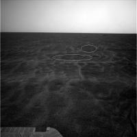
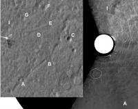
On 2556 we were sitting on one of the slightly darker patches visible in the orbital imagery. Looking south, you can see more dark patches (circled in this navcam view), that basically look like low areas surrounded by light ripples:
You can see more to the north, in the upper right of this frame: http://qt.exploratorium.edu/mars/opportuni...0M1.JPG?sol2556 |
|
|
|
|
|
|
Apr 5 2011, 03:49 PM
Post
#128
|
||
|
Senior Member Group: Moderator Posts: 4279 Joined: 19-April 05 From: .br at .es Member No.: 253 |
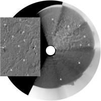
I saw that too and made this polar view in an attempt to correlate it to the HiRISE image.
No luck. 
|
|
|
|
|
|
|
Apr 5 2011, 04:36 PM
Post
#129
|
||
|
Solar System Cartographer Group: Members Posts: 10153 Joined: 5-April 05 From: Canada Member No.: 227 |
So... adding a bit of a stretch factor to Tesheiner's polar pan, and comparing it with Tim Parker's latest route map at JPL, we get this:
Phil -------------------- ... because the Solar System ain't gonna map itself.
Also to be found posting similar content on https://mastodon.social/@PhilStooke Maps for download (free PD: https://upload.wikimedia.org/wikipedia/comm...Cartography.pdf NOTE: everything created by me which I post on UMSF is considered to be in the public domain (NOT CC, public domain) |
|
|
|
|
|
|
Apr 5 2011, 05:03 PM
Post
#130
|
||
|
Senior Member Group: Members Posts: 4246 Joined: 17-January 05 Member No.: 152 |
For my millennial post, let me say that I agree with your ID's, Phil. I'll just indicate the darkened areas I circled in my post above by circling the corresponding areas on your map, Phil:
Enhancing the orbital view really brings out some fascinating detail in this area. It sure would be cool to know the whole history here... |
|
|
|
|
|
|
Apr 5 2011, 06:01 PM
Post
#131
|
||
|
Senior Member Group: Moderator Posts: 4279 Joined: 19-April 05 From: .br at .es Member No.: 253 |
Thanks a lot!
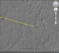
 I logged-in just to post yet another map update (sol 2558) and found your posts above. Now, I'll redo the 2556 plot with Phil's ID and post the map later on (edit: done). Meanwhile just say that today's drive was "only" 65m ESE to the vicinity of crater "C".
This post has been edited by Tesheiner: Apr 5 2011, 06:20 PM |
|
|
|
|
|
|
Apr 5 2011, 08:03 PM
Post
#132
|
|
|
Solar System Cartographer Group: Members Posts: 10153 Joined: 5-April 05 From: Canada Member No.: 227 |
Scott tweeted that the drive would be longer, stopping mid-way for some crater imaging. Is it possible your map shows the midpoint of the drive, or was the drive terminated early?
Phil -------------------- ... because the Solar System ain't gonna map itself.
Also to be found posting similar content on https://mastodon.social/@PhilStooke Maps for download (free PD: https://upload.wikimedia.org/wikipedia/comm...Cartography.pdf NOTE: everything created by me which I post on UMSF is considered to be in the public domain (NOT CC, public domain) |
|
|
|
|
Apr 5 2011, 10:39 PM
Post
#133
|
|
 Senior Member Group: Admin Posts: 3108 Joined: 21-December 05 From: Canberra, Australia Member No.: 615 |
Admin: A few posts on the Peugeot advert were moved to the Mars Rovers in Advertising thread started last year when this first appeared.
|
|
|
|
|
Apr 6 2011, 05:57 AM
Post
#134
|
|
|
Senior Member Group: Moderator Posts: 4279 Joined: 19-April 05 From: .br at .es Member No.: 253 |
QUOTE (Phil Stooke @ Apr 5 2011, 10:03 PM) Scott tweeted that the drive would be longer, stopping mid-way for some crater imaging. Is it possible your map shows the midpoint of the drive, or was the drive terminated early? The latter, I would say. Yestersol pictures are still missing but, based on the info available on the pancam website, the "post-drive" hazcam images correspond to the sequences I'm highlighting here below and no movement actually happened between the two navcam mosaics with SeqIDs 1993 (mid-drive) and 0663 (post-drive). QUOTE 02558::p0025::01::0::0::0::0::0::0::mer_b_sunfind_parms_left_eye_525_exp 02558::p0663::03::6::0::0::6::0::12::navcam_3x1_az_108_3_bpp 02558::p1201::07::2::0::0::2::0::4::front_haz_penultimate_1bpp_pri17 02558::p1211::03::2::0::0::2::0::4::ultimate_front_haz_1_bpp_pri_15 02558::p1254::02::2::0::0::2::0::4::front_haz_fault_pri15_4bpp 02558::p1301::06::2::0::0::2::0::4::rear_haz_penultimate_1bpp_pri17 02558::p1312::07::2::0::0::2::0::4::rear_haz_ultimate_2_bpp_pri15 02558::p1354::01::2::0::0::2::0::4::rear_haz_fault_pri15_4bpp 02558::p1933::06::6::0::0::6::0::12::navcam_3x1_az_45_2_bpp 02558::p2391::27::8::0::0::8::2::18::pancam_drive_direction_4x1_L2R2 02558::p2600::14::2::2::0::0::2::6::pancam_tau For some reason, the drive "faulted" after taking the midpoint navcam mosaic. |
|
|
|
|
Apr 6 2011, 09:32 AM
Post
#135
|
||
|
Senior Member Group: Members Posts: 2820 Joined: 22-April 05 From: Ridderkerk, Netherlands Member No.: 353 |
The Pancam L2 view on Sol 2556.
Jan van Driel
|
|
|
|
|
|
|

|
Lo-Fi Version | Time is now: 27th April 2024 - 06:25 PM |
|
RULES AND GUIDELINES Please read the Forum Rules and Guidelines before posting. IMAGE COPYRIGHT |
OPINIONS AND MODERATION Opinions expressed on UnmannedSpaceflight.com are those of the individual posters and do not necessarily reflect the opinions of UnmannedSpaceflight.com or The Planetary Society. The all-volunteer UnmannedSpaceflight.com moderation team is wholly independent of The Planetary Society. The Planetary Society has no influence over decisions made by the UnmannedSpaceflight.com moderators. |
SUPPORT THE FORUM Unmannedspaceflight.com is funded by the Planetary Society. Please consider supporting our work and many other projects by donating to the Society or becoming a member. |
|