Post Conjunction: Santa Maria to Cape York, The Journey to 'Spirit Point' |

  |
Post Conjunction: Santa Maria to Cape York, The Journey to 'Spirit Point' |
 Apr 10 2011, 04:56 PM Apr 10 2011, 04:56 PM
Post
#166
|
|
 Senior Member  Group: Moderator Posts: 3431 Joined: 11-August 04 From: USA Member No.: 98 |
Responding to CosmicRocker's post in the map thread:
Yes; if there was anything interesting to see in the "dark terrain", it was too subtle at least for me to pick out. Oh well... onward! |
 |
 
|
|
Apr 10 2011, 06:17 PM
Post
#167
|
||
 Senior Member Group: Members Posts: 1084 Joined: 19-February 05 From: Close to Meudon Observatory in France Member No.: 172 |
QUOTE (Stu @ Apr 10 2011, 10:41 AM)  830m ahead is a "double crater" that looks like an interesting place to stop and hang out for a few sols' rest... [attachment=24168:path.jpg]  Your map is great and it feels like reading an old S/F novel wandering among the stars with big voids of space and nothing to see in between... It's af if we just left Sol (Santa Maria) and are heading towards a red dwarf star with its mysterious planet ("double crater"). We are going to fly-by this planet just before encoutering the red dwarf, but we know that we are are irresistibly drawn by the giant Arcturus (Endeavour) Your map is great and it feels like reading an old S/F novel wandering among the stars with big voids of space and nothing to see in between... It's af if we just left Sol (Santa Maria) and are heading towards a red dwarf star with its mysterious planet ("double crater"). We are going to fly-by this planet just before encoutering the red dwarf, but we know that we are are irresistibly drawn by the giant Arcturus (Endeavour) 
|
|
|
|
|
|
|
Apr 10 2011, 07:09 PM
Post
#168
|
|
|
Solar System Cartographer Group: Members Posts: 10153 Joined: 5-April 05 From: Canada Member No.: 227 |
"if there was anything interesting to see in the "dark terrain", it was too subtle at least for me to pick out."
Not much obvious to see, but the surface was noticeably rougher. Elsewhere we had the extremely smooth surface with tiny ripples, as at Eagle crater. Here we had a generally rougher surface, and to me it looked as if a layer about 10 or 20 cm thick had been eroded away to reveal it. It would be interesting to map the distribution of the darker patches all around this area, to see it the distribution offers clues to its origin. Phil -------------------- ... because the Solar System ain't gonna map itself.
Also to be found posting similar content on https://mastodon.social/@PhilStooke Maps for download (free PD: https://upload.wikimedia.org/wikipedia/comm...Cartography.pdf NOTE: everything created by me which I post on UMSF is considered to be in the public domain (NOT CC, public domain) |
|
|
|
|
Apr 10 2011, 11:28 PM
Post
#169
|
|
|
Senior Member Group: Members Posts: 2920 Joined: 14-February 06 From: Very close to the Pyrénées Mountains (France) Member No.: 682 |
I realize that the remaining distance is the same as driving twice around Victoria.
As can understand my french speaking collegues, "autant dire un jet 2 Pi R..." -------------------- |
|
|
|
|
Apr 11 2011, 06:16 AM
Post
#170
|
|
 Senior Member Group: Members Posts: 2228 Joined: 1-December 04 From: Marble Falls, Texas, USA Member No.: 116 |
QUOTE (mhoward @ Apr 10 2011, 11:56 AM) ... Yes; if there was anything interesting to see in the "dark terrain", it was too subtle at least for me to pick out. Oh well... onward! QUOTE (Phil Stooke @ Apr 10 2011, 02:09 PM) ... Not much obvious to see, but the surface was noticeably rougher. Elsewhere we had the extremely smooth surface with tiny ripples, as at Eagle crater. Here we had a generally rougher surface, and to me it looked as if a layer about 10 or 20 cm thick had been eroded away to reveal it. It would be interesting to map the distribution of the darker patches all around this area, to see it the distribution offers clues to its origin. ... It was pretty subtle, alright. Honestly, I was expecting it to be significantly more exciting. I'd have to agree with Phil regarding the surface appearing to be rougher. I was pretty much perplexed until it occurred to me that this dark terrain may simply be a large exposure of the Halfpipe formation. Some of us geologizers had previously started a thread devoted to the Halfpipe formation, where it was revealed that the name was informally applied to certain dark patches of coarse material overlying bedrock. I think one of the best exposures of the "formation" was observed on sols 707-717 as shown in the image I posted almost 5 years ago in the Halfpipe thread. See also, this comment. This is just another reminder about how much fun it has been to do armchair planetary geology through the rover's eyes.
-------------------- ...Tom
I'm not a Space Fan, I'm a Space Exploration Enthusiast. |
|
|
|
|
Apr 11 2011, 10:24 PM
Post
#171
|
||
 The Poet Dude Group: Moderator Posts: 5551 Joined: 15-March 04 From: Kendal, Cumbria, UK Member No.: 60 |
I was
-------------------- |
|
|
|
|
|
|
Apr 11 2011, 11:34 PM
Post
#172
|
|
 Senior Member Group: Admin Posts: 3108 Joined: 21-December 05 From: Canberra, Australia Member No.: 615 |
Nice
Love how the extra details in the "hills" are starting to come out. |
|
|
|
|
Apr 12 2011, 05:08 PM
Post
#173
|
||
|
Senior Member Group: Members Posts: 2821 Joined: 22-April 05 From: Ridderkerk, Netherlands Member No.: 353 |
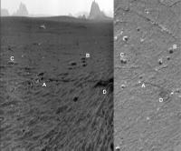
The Pancam L2 view on Sol 2563.
Jan van Driel
|
|
|
|
|
|
|
Apr 12 2011, 05:34 PM
Post
#174
|
||
|
Solar System Cartographer Group: Members Posts: 10153 Joined: 5-April 05 From: Canada Member No.: 227 |
Nice pan! And here's a match to a HiRISE image. The hoped-for long drive was lost, but there should be a drive today.
Phil
-------------------- ... because the Solar System ain't gonna map itself.
Also to be found posting similar content on https://mastodon.social/@PhilStooke Maps for download (free PD: https://upload.wikimedia.org/wikipedia/comm...Cartography.pdf NOTE: everything created by me which I post on UMSF is considered to be in the public domain (NOT CC, public domain) |
|
|
|
|
|
|
Apr 12 2011, 06:17 PM
Post
#175
|
||
|
The Poet Dude Group: Moderator Posts: 5551 Joined: 15-March 04 From: Kendal, Cumbria, UK Member No.: 60 |
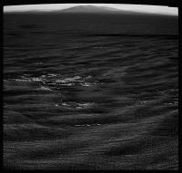
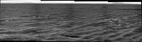
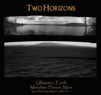
Just briefly going back to my image of the "hills on the horizon", I came across a rather great coincidence. Stella and I went camping on Sunday, to a beautiful nearby lake called Ullswater, and as soon as we had set up camp I started taking pictures, as you do. Breathtaking view from our tent, right across the lake to the hills and mountains beyond...
...and (if I've read it correctly!) checking the always-useful MER filename decoder I found that the images I used to make my "hills on the horizon" pic were taken at just before 3pm on Sunday, Earth time, at exactly the same time I was taking my pics of Ullswater. Hence, just for fun and novelty value...
Just liked the idea of it, that's all... me, sitting there, by my tent, taking pictures of faraway hills, while Oppy, sitting there in the middle of Meridiani, was doing exactly the same thing... (colour version of Ullswater pic here ) -------------------- |
|
|
|
|
|
|
Apr 12 2011, 07:17 PM
Post
#176
|
|
 Member Group: Members Posts: 655 Joined: 22-January 06 Member No.: 655 |
Very nice juxtaposition Stu.
I remember camping in that vicinity in my student days - don't recall many opportunities to log on though... |
|
|
|
|
Apr 12 2011, 07:23 PM
Post
#177
|
|
 Member Group: Members Posts: 593 Joined: 20-April 05 Member No.: 279 |
Great choice of location, Stu.
Here's The Ullswater, a new measure of scale:  About the same length as Santa Maria to Endeavour! Andy |
|
|
|
|
Apr 12 2011, 07:24 PM
Post
#178
|
|
|
The Poet Dude Group: Moderator Posts: 5551 Joined: 15-March 04 From: Kendal, Cumbria, UK Member No.: 60 |
QUOTE (jasedm @ Apr 12 2011, 08:17 PM) don't recall many opportunities to log on though... That's why I love my mobile's net browsing capability. Sat on the lake shore, glass of red wine *there*, big bag of Butterkist popcorn **there**, and looking at new images of Mars as the Sun went down behind the fells, over ***there***... Priceless. -------------------- |
|
|
|
|
Apr 12 2011, 08:23 PM
Post
#179
|
|
 Member Group: Members Posts: 699 Joined: 3-December 04 From: Boulder, Colorado, USA Member No.: 117 |
QUOTE (AndyG @ Apr 12 2011, 08:23 PM) Here's The Ullswater, a new measure of scale: ... About the same length as Santa Maria to Endeavour! I'll spare everyone the pictures of me, aged seven, paddling in Ullswater with a toy boat, but instead I will note that I think the "Ullswater" unit needs recalibrating. The lake is 7-9 miles long (from Wikipedia), and the distance from Santa Maria to Cape York is only about 3.5 miles. Yeah- only half an Ullswater to go! John |
|
|
|
|
Apr 12 2011, 08:38 PM
Post
#180
|
|
|
Founder Group: Chairman Posts: 14432 Joined: 8-February 04 Member No.: 1 |
The horizon drop-off might be analogous though - Mars being a smaller ball etc etc.
|
|
|
|
|

|
Lo-Fi Version | Time is now: 28th April 2024 - 05:53 PM |
|
RULES AND GUIDELINES Please read the Forum Rules and Guidelines before posting. IMAGE COPYRIGHT |
OPINIONS AND MODERATION Opinions expressed on UnmannedSpaceflight.com are those of the individual posters and do not necessarily reflect the opinions of UnmannedSpaceflight.com or The Planetary Society. The all-volunteer UnmannedSpaceflight.com moderation team is wholly independent of The Planetary Society. The Planetary Society has no influence over decisions made by the UnmannedSpaceflight.com moderators. |
SUPPORT THE FORUM Unmannedspaceflight.com is funded by the Planetary Society. Please consider supporting our work and many other projects by donating to the Society or becoming a member. |
|