Post Conjunction: Santa Maria to Cape York, The Journey to 'Spirit Point' |

  |
Post Conjunction: Santa Maria to Cape York, The Journey to 'Spirit Point' |
 Jun 12 2011, 01:21 PM Jun 12 2011, 01:21 PM
Post
#571
|
|
|
Member  Group: Members Posts: 128 Joined: 28-October 08 From: Boston, MA Member No.: 4469 |
QUOTE (kenny @ Jun 12 2011, 06:43 AM)  We've already had one Apollo craft name, Gumdrop, the Command Module from Apollo 9. Yes, and we had Yankee Clipper and Intrepid shortly before arriving at Santa Maria. Plus we can't forget that the very first crater we saw was named Eagle. And although it wasn't a direct Apollo reference, Endeavour was the name of the Apollo 15 CSM. Personally though I think it would be great to have a crater named "Snoopy". |
 |
 
|
|
Jun 12 2011, 09:21 PM
Post
#572
|
|
|
Member Group: Members Posts: 910 Joined: 4-September 06 From: Boston Member No.: 1102 |
QUOTE (Tesheiner @ Jun 7 2011, 04:41 PM) Scott Maxwell tweeted: "What's better than driving a Mars rover? Driving a Mars rover with Paolo. Today, maybe ~ 100m with drive-by imaging of a crater for Matt G.". Anyone know if they got the drive-by images. If they did, must be lower priority than dirve direction images. -------------------- |
|
|
|
|
Jun 12 2011, 09:40 PM
Post
#573
|
|
 Senior Member Group: Admin Posts: 4763 Joined: 15-March 05 From: Glendale, AZ Member No.: 197 |
QUOTE (Stu @ Jun 12 2011, 05:10 AM) 3D view of "Crater Cluster"... Looks like a corduroy jacket with cigarette burns. -------------------- If Occam had heard my theory, things would be very different now.
|
|
|
|
|
Jun 12 2011, 09:57 PM
Post
#574
|
|
|
Senior Member Group: Members Posts: 3516 Joined: 4-November 05 From: North Wales Member No.: 542 |
QUOTE (Floyd @ Jun 12 2011, 10:21 PM) Anyone know if they got the drive-by images. That's the question I've been holding off asking all day because I don't like to sound impatient  . .I think they must have, but I don't know. I want to see the southern horizon. |
|
|
|
|
Jun 12 2011, 10:01 PM
Post
#575
|
|
 Senior Member Group: Moderator Posts: 2262 Joined: 9-February 04 From: Melbourne - Oz Member No.: 16 |
QUOTE (Floyd @ Jun 12 2011, 10:21 PM) Anyone know if they got the drive-by images. If they did, must be lower priority than dirve direction images. Yes, they were taken (Don't expect anything spectacular though, a single colour pancan of a 'ray' and some navcams) And yes, images like this always have a much lower priority, drive images are needed right away to plan the next drive, science ones can sometimes take weeks to make it down. -------------------- |
|
|
|
|
Jun 12 2011, 10:29 PM
Post
#576
|
|
|
Senior Member Group: Members Posts: 3516 Joined: 4-November 05 From: North Wales Member No.: 542 |
James, you obviously know exactly what to expect. Can you point us to the source of that information?
|
|
|
|
|
Jun 13 2011, 12:55 AM
Post
#577
|
||
 Senior Member Group: Members Posts: 2173 Joined: 28-December 04 From: Florida, USA Member No.: 132 |
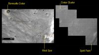
It's interesting to note that from "crater cluster" to Spirit Point, Opportunity has about the same distance to traverse as Spirit did on its trek from Bonneville Crater to West Spur in the Columbia Hills. Who could have known such a comparison could be made seven years later!
Source maps: http://marsrover.nasa.gov/mission/tm-spiri...rit-sol517.html http://www.unmannedspaceflight.com/index.p...st&p=173814 |
|
|
|
|
|
|
Jun 13 2011, 02:24 AM
Post
#578
|
|
|
Senior Member Group: Admin Posts: 4763 Joined: 15-March 05 From: Glendale, AZ Member No.: 197 |
... or viewed in the context of "almost there."
-------------------- If Occam had heard my theory, things would be very different now.
|
|
|
|
|
Jun 13 2011, 06:08 AM
Post
#579
|
|
|
Founder Group: Chairman Posts: 14432 Joined: 8-February 04 Member No.: 1 |
QUOTE (ngunn @ Jun 12 2011, 03:29 PM) James, you obviously know exactly what to expect. Can you point us to the source of that information? The Pancam tracking database holds that information. What's planned. What's taken. What's yet to be transmitted. What's received. My advice would be to just enjoy the results of those who know where it is and how to use it. It's hard to use, slow, and a very constrained resource. |
|
|
|
|
Jun 13 2011, 07:51 AM
Post
#580
|
|
|
Senior Member Group: Members Posts: 3516 Joined: 4-November 05 From: North Wales Member No.: 542 |
QUOTE (djellison @ Jun 13 2011, 07:08 AM) advice Taken! 
|
|
|
|
|
Jun 13 2011, 09:15 AM
Post
#581
|
|
|
Member Group: Members Posts: 910 Joined: 4-September 06 From: Boston Member No.: 1102 |
Thanks for the information James--as expected on priority.
-------------------- |
|
|
|
|
Jun 13 2011, 02:53 PM
Post
#582
|
|
|
Senior Member Group: Moderator Posts: 2262 Joined: 9-February 04 From: Melbourne - Oz Member No.: 16 |
Yes, as Doug says the information is from the tracking site which is a massively useful resource (map making, MMB metadata, thumbnail images, planned sequences, etc.) and as such the last thing we want to do is overuse it hand have it closed off.
For those of you who don't know, over recent weeks I've started posting a daily tweet summarizing what Oppy is up to based largely on the tracking data. So even less reason for others to need to query the database themselves. http://twitter.com/nivnac James -------------------- |
|
|
|
|
Jun 13 2011, 07:43 PM
Post
#583
|
|
 Senior Member Group: Members Posts: 4247 Joined: 17-January 05 Member No.: 152 |
QUOTE (Floyd @ Jun 12 2011, 09:21 PM) Anyone know if they got the drive-by images. Some navcams are now down: http://qt.exploratorium.edu/mars/opportuni...0M1.JPG?sol2621 |
|
|
|
|
Jun 13 2011, 07:54 PM
Post
#584
|
||
|
Senior Member Group: Members Posts: 1074 Joined: 21-September 07 From: Québec, Canada Member No.: 3908 |
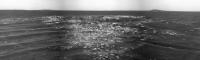
Gemini 5 crater navcam panorama:
|
|
|
|
|
|
|
Jun 13 2011, 08:44 PM
Post
#585
|
|
|
Member Group: Members Posts: 235 Joined: 2-August 05 Member No.: 451 |
Full inline quote removed. You've been here > half a decade - you should know better - ADMIN
Wow, I don't recall ever seeing such clear images showing that the rocks excavated by the crater formation landed after the dune formation... and that the dunes haven't substantially moved since then. |
|
|
|
|

|
Lo-Fi Version | Time is now: 24th May 2024 - 05:26 PM |
|
RULES AND GUIDELINES Please read the Forum Rules and Guidelines before posting. IMAGE COPYRIGHT |
OPINIONS AND MODERATION Opinions expressed on UnmannedSpaceflight.com are those of the individual posters and do not necessarily reflect the opinions of UnmannedSpaceflight.com or The Planetary Society. The all-volunteer UnmannedSpaceflight.com moderation team is wholly independent of The Planetary Society. The Planetary Society has no influence over decisions made by the UnmannedSpaceflight.com moderators. |
SUPPORT THE FORUM Unmannedspaceflight.com is funded by the Planetary Society. Please consider supporting our work and many other projects by donating to the Society or becoming a member. |
|