Post Conjunction: Santa Maria to Cape York, The Journey to 'Spirit Point' |

  |
Post Conjunction: Santa Maria to Cape York, The Journey to 'Spirit Point' |
 Jun 24 2011, 08:33 PM Jun 24 2011, 08:33 PM
Post
#661
|
|
|
Senior Member  Group: Moderator Posts: 4279 Joined: 19-April 05 From: .br at .es Member No.: 253 |
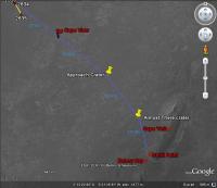
I presume the "bump" to the left of it is "Cape Approach" crater, the feature we have been following from some time ago. In that case, Cape York must still be located to the left of the crater. Check here.
|
 |
 
|
|
Jun 24 2011, 09:47 PM
Post
#662
|
|
|
Junior Member Group: Members Posts: 71 Joined: 19-January 10 From: Grimsby, N.E. Lincs, UK Member No.: 5179 |
QUOTE (Tesheiner @ Jun 24 2011, 09:33 PM)  Cape York must still be located to the left of the crater. Check here. Is that the case even though we're driving backwards?   Neil |
|
|
|
|
Jun 25 2011, 12:37 PM
Post
#663
|
||
 The Poet Dude Group: Moderator Posts: 5551 Joined: 15-March 04 From: Kendal, Cumbria, UK Member No.: 60 |
Purely for fun, not claiming any scientific accuracy or nuttn, here's (red flag) where I think we'll see Cape York properly for the first time...
More coffee- and spicy Nik Nak-fuelled speculation here... http://roadtoendeavour.wordpress.com/2011/...first-view-soon -------------------- |
|
|
|
|
|
| Guest_Sunspot_* |
Jun 25 2011, 01:20 PM
Post
#664
|
|
Guests |
The blue numbers in that image represent height? If so, I would say Cape York is going to appear quite suddenly and dramatically.
|
|
|
|
|
Jun 25 2011, 01:28 PM
Post
#665
|
|
|
The Poet Dude Group: Moderator Posts: 5551 Joined: 15-March 04 From: Kendal, Cumbria, UK Member No.: 60 |
No, the blue numbers are distances between points in metres.
-------------------- |
|
|
|
|
Jun 25 2011, 02:29 PM
Post
#666
|
|
|
Senior Member Group: Moderator Posts: 4279 Joined: 19-April 05 From: .br at .es Member No.: 253 |
QUOTE (Stu @ Jun 25 2011, 02:37 PM) ... here's (red flag) where I think we'll see Cape York properly for the first time... It might be at that point or perhaps a few hundred meters further but in any case we are talking about just a few weeks (three, two, one?) in the future.   PS: Those of you planning to leave on vacations this next month should stay always close to a cybercafe.
|
|
|
|
|
Jun 25 2011, 02:37 PM
Post
#667
|
||
|
Junior Member Group: Members Posts: 59 Joined: 18-July 07 From: London, UK Member No.: 2873 |
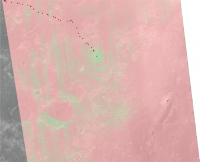
Been meaning to do this for a while - time to dust off my HiRISE DEM of this area...
Below is an animation of the calculated visible terrain from Oppy (1.5 m off ground) at different points in the traverse. Starting at the position as of Sol 2635, and moving towards the general direction of Cape York. In these images, pink = not visible, green = visible. The red dots are the previous positions (from Tesh's awesome KML files, imported into ArcGIS), with an extra dot showing the approximate highest point of Cape York. The green dot is a moving Oppy from which the visibility is calculated. The striping is a result of the DEM-build process and the HiRISE CCD strips. And as this area is so flat the method is fairly sensitive to noise in the DEM on the scale of about a metre or so (this means that there could be small local highs or lows affecting the result). Anyway, safety warning over, here goes...
If this is right, then it seems like Cape York won't appear until we really are right on top of it. I make it about another 1.5 km until it should pop up, or about 500 m away from Cape York itself. Well, there's my reputation on the line, let's sit back and watch the horizon!  Pete |
|
|
|
|
|
|
Jun 25 2011, 02:53 PM
Post
#668
|
||
|
Member Group: Members Posts: 111 Joined: 14-March 05 From: Vastitas Borealis Member No.: 193 |
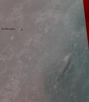
For those in possession of red-and-blue glasses, a glance at this image (with 'X' over Oppy's last position) reveals immediately why we can't see Cape York yet. However, the rise between us and our destination is so evenly swine-backed (convex) that I find it next to impossible to evaluate when or where our first sighting of the Cape will occur. But anyways, I think this must happen before our arrival at the 'Approach Crater'.
Attached thumbnail(s)
|
|
|
|
|
|
|
Jun 25 2011, 11:03 PM
Post
#669
|
||
|
The Poet Dude Group: Moderator Posts: 5551 Joined: 15-March 04 From: Kendal, Cumbria, UK Member No.: 60 |
Beautiful view...
-------------------- |
|
|
|
|
|
|
Jun 26 2011, 11:20 AM
Post
#670
|
||
|
Senior Member Group: Members Posts: 2835 Joined: 22-April 05 From: Ridderkerk, Netherlands Member No.: 353 |
Panoramic view on Sol 2636.
Taken with the L2 Pancam. Jan van Driel
|
|
|
|
|
|
|
Jun 26 2011, 06:35 PM
Post
#671
|
|
 Member Group: Members Posts: 399 Joined: 28-August 07 From: San Francisco Member No.: 3511 |
From Google Mars, the terrain between "Approach" crater and Cape York appears suspiciously void of ripples yet the dust/soil coating appears thick enough (for a Spirit style trap) and has a subdued mottled look. I wonder if Oppy needs a toe-dip in this stuff ?
-------------------- 'She drove until the wheels fell off...'
|
|
|
|
|
Jun 26 2011, 07:18 PM
Post
#672
|
|
 Senior Member Group: Members Posts: 4247 Joined: 17-January 05 Member No.: 152 |
QUOTE (eoincampbell @ Jun 26 2011, 06:35 PM) suspiciously void of ripples We've crossed a lot of ground (around Santa Maria) that was basically free of ripples.The ground in the final approach to CY does look different from the standard Meridiani plains. But I'd think that's because of the topography which starts to drop into Endeavour, and possibly different bedrock geologically speaking. That's another thing I'm looking forward to seeing up close... |
|
|
|
| Guest_Oersted_* |
Jun 27 2011, 12:13 AM
Post
#673
|
|
Guests |
QUOTE (marswiggle @ Jun 25 2011, 04:53 PM) For those in possession of red-and-blue glasses, a glance at this image (with 'X' over Oppy's last position) reveals immediately why we can't see Cape York yet. Thanks, that is really great. Get out those glasses for those of you who haven't yet! |
|
|
|
|
Jun 27 2011, 03:14 AM
Post
#674
|
|
|
Senior Member Group: Members Posts: 1044 Joined: 17-February 09 Member No.: 4605 |
Although a x-eye version would do the job for those of us without the glasses.
|
|
|
|
|
Jun 27 2011, 05:15 AM
Post
#675
|
|
|
The Poet Dude Group: Moderator Posts: 5551 Joined: 15-March 04 From: Kendal, Cumbria, UK Member No.: 60 |
There's no reason for anyone *not* to have glasses nowadays. Go into your local newsagent/magazine retailer, or discount bookshop and there'll be two or three kids mags or books about 'horrible bugs', 'terrible dinosaurs' or 'creepy crawlies' with 3D pics and glasses, I guarantee you.
-------------------- |
|
|
|
|

|
Lo-Fi Version | Time is now: 26th May 2024 - 04:26 AM |
|
RULES AND GUIDELINES Please read the Forum Rules and Guidelines before posting. IMAGE COPYRIGHT |
OPINIONS AND MODERATION Opinions expressed on UnmannedSpaceflight.com are those of the individual posters and do not necessarily reflect the opinions of UnmannedSpaceflight.com or The Planetary Society. The all-volunteer UnmannedSpaceflight.com moderation team is wholly independent of The Planetary Society. The Planetary Society has no influence over decisions made by the UnmannedSpaceflight.com moderators. |
SUPPORT THE FORUM Unmannedspaceflight.com is funded by the Planetary Society. Please consider supporting our work and many other projects by donating to the Society or becoming a member. |
|