Dawn Survey Orbit Phase, First orbital phase |

  |
Dawn Survey Orbit Phase, First orbital phase |
 Jul 22 2011, 07:53 PM Jul 22 2011, 07:53 PM
Post
#91
|
|
|
Solar System Cartographer  Group: Members Posts: 10153 Joined: 5-April 05 From: Canada Member No.: 227 |
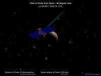
Dawn's looping round the north side now, so the 'where is Dawn' page is showing an illuminated crescent:
http://neo.jpl.nasa.gov/orbits/fullview4.jpg (presumably that links to the current image, when you link to it, not the version I am looking at now) Enough of the surface is visible to see that the texture map currently in use is really from Tethys! Penelope and the chain of craters to its west are visible right now. Phil -------------------- ... because the Solar System ain't gonna map itself.
Also to be found posting similar content on https://mastodon.social/@PhilStooke Maps for download (free PD: https://upload.wikimedia.org/wikipedia/comm...Cartography.pdf NOTE: everything created by me which I post on UMSF is considered to be in the public domain (NOT CC, public domain) |
 |
 
|
|
Jul 22 2011, 08:04 PM
Post
#92
|
||
 Administrator Group: Admin Posts: 5172 Joined: 4-August 05 From: Pasadena, CA, USA, Earth Member No.: 454 |
 Funny, and well spotted! I've attached the current screenshot, since it will have changed by the time some people here look at it. Funny, and well spotted! I've attached the current screenshot, since it will have changed by the time some people here look at it.
Attached thumbnail(s)
-------------------- My website - My Patreon - @elakdawalla on Twitter - Please support unmannedspaceflight.com by donating here.
|
|
|
|
|
|
|
Jul 23 2011, 12:28 PM
Post
#93
|
||
|
Solar System Cartographer Group: Members Posts: 10153 Joined: 5-April 05 From: Canada Member No.: 227 |
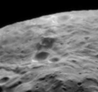
Here's a crater - middle of this view - with dark markings inside and outside its rim. Other distant images show at least one other dark spot like this as well.
Phil
-------------------- ... because the Solar System ain't gonna map itself.
Also to be found posting similar content on https://mastodon.social/@PhilStooke Maps for download (free PD: https://upload.wikimedia.org/wikipedia/comm...Cartography.pdf NOTE: everything created by me which I post on UMSF is considered to be in the public domain (NOT CC, public domain) |
|
|
|
|
|
|
Jul 23 2011, 02:31 PM
Post
#94
|
|
 Senior Member Group: Admin Posts: 4763 Joined: 15-March 05 From: Glendale, AZ Member No.: 197 |
It looks like maybe a fresh impact inside an older crater.
-------------------- If Occam had heard my theory, things would be very different now.
|
|
|
|
|
Jul 23 2011, 02:34 PM
Post
#95
|
|
|
Solar System Cartographer Group: Members Posts: 10153 Joined: 5-April 05 From: Canada Member No.: 227 |
I'd say excavation of dark subsurface material.
Phil -------------------- ... because the Solar System ain't gonna map itself.
Also to be found posting similar content on https://mastodon.social/@PhilStooke Maps for download (free PD: https://upload.wikimedia.org/wikipedia/comm...Cartography.pdf NOTE: everything created by me which I post on UMSF is considered to be in the public domain (NOT CC, public domain) |
|
|
|
|
Jul 23 2011, 10:13 PM
Post
#96
|
||
 Member Group: Members Posts: 568 Joined: 20-April 05 From: Silesia Member No.: 299 |
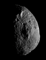
I'm curious if MYSTIC simulator use real data to create the image of Vesta ? Is this a true picture of Vesta? If it corresponds to reality, it is very interesting.
Ion engine is not operating from a few hours, I hope that the framing camera just works. -------------------- Free software for planetary science (including Cassini Image Viewer).
http://members.tripod.com/petermasek/marinerall.html |
|
|
|
|
|
|
Jul 23 2011, 11:09 PM
Post
#97
|
|
 Member Group: Members Posts: 259 Joined: 23-January 05 From: Seattle, WA Member No.: 156 |
As Phil pointed out yesterday, that's Tethys.
|
|
|
|
|
Jul 24 2011, 02:38 AM
Post
#98
|
|
|
Administrator Group: Admin Posts: 5172 Joined: 4-August 05 From: Pasadena, CA, USA, Earth Member No.: 454 |
If our images of Vesta were already that good, we'd have no need of a Dawn mission...
-------------------- My website - My Patreon - @elakdawalla on Twitter - Please support unmannedspaceflight.com by donating here.
|
|
|
|
|
Jul 24 2011, 02:50 AM
Post
#99
|
||
 Senior Member Group: Moderator Posts: 2785 Joined: 10-November 06 From: Pasadena, CA Member No.: 1345 |
QUOTE (Phil Stooke @ Jul 23 2011, 07:28 AM)  Here's a crater - middle of this view - with dark markings inside and outside its rim. Other distant images show at least one other dark spot like this as well. Tried to line up the IR image with this view. If I got it right, that crater is right in the middle of a "greenish" splatty zone. This is the same tint as the sharp scarp face. There are two other greenish splatty zones below the central peak in the image, but I'm almost positive this area is misregistered. I'm going to run with the idea that the green tint indicates fresher material.
-------------------- Some higher resolution images available at my photostream: http://www.flickr.com/photos/31678681@N07/
|
|
|
|
|
|
|
Jul 24 2011, 02:56 AM
Post
#100
|
||
|
Senior Member Group: Moderator Posts: 2785 Joined: 10-November 06 From: Pasadena, CA Member No.: 1345 |
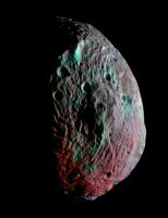
BTW, here's the blink animation between the original black and white image, and the manually warped IR image:
[animated GIF: Click to animate] -------------------- Some higher resolution images available at my photostream: http://www.flickr.com/photos/31678681@N07/
|
|
|
|
|
|
|
Jul 24 2011, 10:21 AM
Post
#101
|
|
 Member Group: Members Posts: 288 Joined: 28-September 05 From: Orion arm Member No.: 516 |
QUOTE I have been playing with a very rough map of Vesta from the released images. Please bear in mind this is VERY approximate and not controlled by any shape model or pointing information. It is intended just to show approximate image coverage and locations of major features. The tie to more distant images is very rough. Zero longitude in the Hubble map/shape model coordinates would be at the left end (and the right, I guess). A much earlier version of this, posted here earlier, used a different (arbitrary) zero longitude. Phil As your rough map is rather disorted it would be interesting to see a south polar view, probably with a grid. For sure that is only a approximate but a nice overview showing locations of major features |
|
|
|
|
Jul 25 2011, 06:59 AM
Post
#102
|
||
 Senior Member Group: Members Posts: 2492 Joined: 15-January 05 From: center Italy Member No.: 150 |
In the last hours, Dawn turned off it's engines and distance/speed are quite stable; this could means he reached a circular orbit but, looking to the plots below, actual speed/energy are below such a level, suggesting that probe is near the apoapsis of an elongated orbit:
Indeed, current orbit should be almost circular (5500x5200 km, e=0,028) with a 161 hours period. Obviously, this is true until next (imminent) engine burn, which should be in direction roughly opposite to orbital motion in order to have a progressive distance reduction, spiraling toward survey orbit... Note: In all my figures, I am assuming that distance declared in the simulator is measured from Vesta's centre... -------------------- I always think before posting! - Marco -
|
|
|
|
|
|
|
Jul 25 2011, 01:45 PM
Post
#103
|
|
|
Solar System Cartographer Group: Members Posts: 10153 Joined: 5-April 05 From: Canada Member No.: 227 |
"it would be interesting to see a south polar view, probably with a grid."
For the time being I will not do this. Better to leave it to the Dawn team to do a proper one. Think of my map as just a guide to image coverage at the moment. For one thing, the latitude scaling is very uncertain. Meanwhile Dawn has looped over the north pole, and then the equator over the weekend, and it's now back over the south pole. Phil -------------------- ... because the Solar System ain't gonna map itself.
Also to be found posting similar content on https://mastodon.social/@PhilStooke Maps for download (free PD: https://upload.wikimedia.org/wikipedia/comm...Cartography.pdf NOTE: everything created by me which I post on UMSF is considered to be in the public domain (NOT CC, public domain) |
|
|
|
|
Jul 25 2011, 04:37 PM
Post
#104
|
|
 Senior Member Group: Members Posts: 1887 Joined: 20-November 04 From: Iowa Member No.: 110 |
Next Monday on NASA TV:
QUOTE August 1, Monday
2 p.m. - NASA Science News Conference - Dawn Images of the Vesta Asteroid - JPL (Public, HD and Media Channels) |
|
|
|
|
Jul 25 2011, 06:29 PM
Post
#105
|
|
|
Administrator Group: Admin Posts: 5172 Joined: 4-August 05 From: Pasadena, CA, USA, Earth Member No.: 454 |
Goody goody

-------------------- My website - My Patreon - @elakdawalla on Twitter - Please support unmannedspaceflight.com by donating here.
|
|
|
|
|

|
Lo-Fi Version | Time is now: 27th April 2024 - 04:56 PM |
|
RULES AND GUIDELINES Please read the Forum Rules and Guidelines before posting. IMAGE COPYRIGHT |
OPINIONS AND MODERATION Opinions expressed on UnmannedSpaceflight.com are those of the individual posters and do not necessarily reflect the opinions of UnmannedSpaceflight.com or The Planetary Society. The all-volunteer UnmannedSpaceflight.com moderation team is wholly independent of The Planetary Society. The Planetary Society has no influence over decisions made by the UnmannedSpaceflight.com moderators. |
SUPPORT THE FORUM Unmannedspaceflight.com is funded by the Planetary Society. Please consider supporting our work and many other projects by donating to the Society or becoming a member. |
|