Dawn Survey Orbit Phase, First orbital phase |

  |
Dawn Survey Orbit Phase, First orbital phase |
 Jul 29 2011, 05:48 AM Jul 29 2011, 05:48 AM
Post
#121
|
|
|
Senior Member  Group: Members Posts: 2082 Joined: 13-February 10 From: Ontario Member No.: 5221 |
Iapetus, eat your heart out; we have a new snowman!
Vesta is the rock of a thousand faces, indeed (though this doesn't look like a very 'dark' side like the caption says, IMO). |
 |
 
|
|
Jul 29 2011, 05:58 AM
Post
#122
|
|
 Senior Member Group: Moderator Posts: 3233 Joined: 11-February 04 From: Tucson, AZ Member No.: 23 |
QUOTE (ElkGroveDan @ Jul 28 2011, 09:38 PM)  Unusual dark splat on the inside of the crater. Remembering my crater dynamics, that would mean that it JUST touched a darker, mafic layer (remember boys and girls, basalt is at the surface (or was at least when it formed, gabbro is below your feet, so not knowing where this stuff was formed, let's just say mafic) By the way, I am definitely printing that picture for my wall in my office.... Where is the swear jar? ***** **** ***** *****!!! -------------------- &@^^!% Jim! I'm a geologist, not a physicist!
The Gish Bar Times - A Blog all about Jupiter's Moon Io |
|
|
|
|
Jul 29 2011, 06:33 AM
Post
#123
|
|
|
Junior Member Group: Members Posts: 50 Joined: 27-June 11 From: Katlenburg-Lindau, Lower Saxony, Germany Member No.: 6038 |
QUOTE (mchan @ Jul 29 2011, 06:27 AM) If I have been following this correctly, the July 23 view is of the north on the night side, yes? Indeed, this is a view over the dark north pole and part of the northern hemisphere. And, btw, the surroundings of the snowman craters ARE indeed visibly darker, I promise. -------------------- |
|
|
|
|
Jul 29 2011, 07:03 AM
Post
#124
|
|
 Senior Member Group: Members Posts: 1421 Joined: 26-July 08 Member No.: 4270 |
That's one huge groove.

-------------------- -- Hungry4info (Sirius_Alpha)
|
|
|
|
|
Jul 29 2011, 07:19 AM
Post
#125
|
|
|
Senior Member Group: Members Posts: 2082 Joined: 13-February 10 From: Ontario Member No.: 5221 |
I thought the caption meant dark in the same way there's a colloquial 'dark side' of the moon.
If the north actually is darker than the south (and not just shadow), then I stand corrected! |
|
|
|
|
Jul 29 2011, 10:53 AM
Post
#126
|
|
|
Member Group: Members Posts: 813 Joined: 29-December 05 From: NE Oh, USA Member No.: 627 |
New Event Time NASA To Unveil Vesta Images At News Conference
Monday Aug 1 at noon EDT (changed from 2:00pm) Update -- New Event Time NASA To Unveil Vesta Images At News Conference WASHINGTON -- NASA will host a news conference on Monday, Aug. 1, at noon EDT, to discuss the Dawn spacecraft's successful orbit insertion around Vesta on July 15 and unveil the first full-frame images from Dawn's framing camera. The news conference will be held in the Von Karman auditorium at NASA's Jet Propulsion Laboratory (JPL), 4800 Oak Grove Dr., Pasadena, Calif. Journalists also may ask questions from participating NASA locations or join by phone. To obtain dial-in information, journalists must contact JPL's Media Relations Office at 818-354-5011 by 8 a.m. PDT on Aug. 1. NASA Television and the agency's website will broadcast the event. It also will be carried live on Ustream, with a live chat box available, at: http://www.ustream.tv/nasajpl2 |
|
|
|
|
Jul 29 2011, 01:30 PM
Post
#127
|
|
|
Solar System Cartographer Group: Members Posts: 10153 Joined: 5-April 05 From: Canada Member No.: 227 |
To clarify the 'dark' description... and see the camera facebook page for more of those comments! - Vesta has a large low albedo feature on its equator in one hemisphere, first seen using speckle interferometry by Jack Drummond and colleagues in the 90s, and confirmed by Hubble. It is referred to as Olbers and is used as the zero longitude in the Hubble-derived shape model. This image includes the darker longitudes at low latitudes. It is the low-albedo side.
Phil EDIT - now the caption suggests it referred to passing over the dark (= unilluminated) side prior to taking this image... -------------------- ... because the Solar System ain't gonna map itself.
Also to be found posting similar content on https://mastodon.social/@PhilStooke Maps for download (free PD: https://upload.wikimedia.org/wikipedia/comm...Cartography.pdf NOTE: everything created by me which I post on UMSF is considered to be in the public domain (NOT CC, public domain) |
|
|
|
|
Jul 29 2011, 01:36 PM
Post
#128
|
||
 IMG to PNG GOD Group: Moderator Posts: 2250 Joined: 19-February 04 From: Near fire and ice Member No.: 38 |
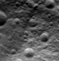
The latest image is interesting. The dark area to the right of and a bit below center is interesting. I get the impression that is is at least partially caused by topography. But there is another dark area left of center and its right edge is rather sharply defined. It even seems that some craters may have been partially erased there - this is going to be interesting to see at higher resolution:
If these dark/brighter areas are mostly albedo variations Vesta has remarkably big albedo variations. It's going to be interesting to create DEMs of Vesta using stereo imagery once the raw image data appears at the PDS. Doing so should distinguish between topography and albedo variations (anaglyphs, more images or even false color images might do so as well). Vesta now looks like a weird mix of Miranda, Mimas, grooved asteroids/satellites and possibly Hyperion to me. But mostly it's just uniquely Vesta. |
|
|
|
|
|
|
Jul 29 2011, 02:13 PM
Post
#129
|
||
|
Solar System Cartographer Group: Members Posts: 10153 Joined: 5-April 05 From: Canada Member No.: 227 |
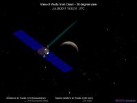
A comparison view to show where we are...
Phil
-------------------- ... because the Solar System ain't gonna map itself.
Also to be found posting similar content on https://mastodon.social/@PhilStooke Maps for download (free PD: https://upload.wikimedia.org/wikipedia/comm...Cartography.pdf NOTE: everything created by me which I post on UMSF is considered to be in the public domain (NOT CC, public domain) |
|
|
|
|
|
|
Jul 29 2011, 03:52 PM
Post
#130
|
||
|
Solar System Cartographer Group: Members Posts: 10153 Joined: 5-April 05 From: Canada Member No.: 227 |
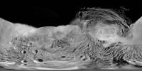
... and a map. Very approximate and uncontrolled still.
Phil
-------------------- ... because the Solar System ain't gonna map itself.
Also to be found posting similar content on https://mastodon.social/@PhilStooke Maps for download (free PD: https://upload.wikimedia.org/wikipedia/comm...Cartography.pdf NOTE: everything created by me which I post on UMSF is considered to be in the public domain (NOT CC, public domain) |
|
|
|
|
|
|
Jul 29 2011, 03:52 PM
Post
#131
|
||
 Senior Member Group: Members Posts: 2492 Joined: 15-January 05 From: center Italy Member No.: 150 |
Engines on again!
Attached thumbnail(s)
-------------------- I always think before posting! - Marco -
|
|
|
|
|
|
|
Jul 29 2011, 05:07 PM
Post
#132
|
||
 Member Group: Members Posts: 290 Joined: 29-December 05 From: Ottawa, ON Member No.: 624 |
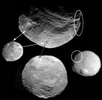
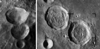
I can't help but get a sense of familiarity with those two large craters. Ritter and Sabine from Ranger has a close resemblance. In any case, the flat floored nature of the craters seem out of place on such a small body.
Attached thumbnail(s)
|
|
|
|
|
|
|
Jul 29 2011, 05:47 PM
Post
#133
|
||
 Administrator Group: Admin Posts: 5172 Joined: 4-August 05 From: Pasadena, CA, USA, Earth Member No.: 454 |
Aha, Steve G, that's what made them so strange-looking -- most of the craters on Vesta seem to be simple bowl shapes, but these do have flat floors.
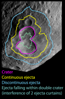
Here's a cartoon of what I think I see. (Warning: this is more arm-wavey and speculative than my usual -- so it's probably wrong but I couldn't help but try to interpret this.) I'm not sure if the "head" of the snowman formed at the same time as the other two craters -- it looks more rounded so I think it predated the other two. But I think the other two formed at the same time (outlined in pink). You can see an area immediately surrounding the two craters that is almost devoid of impact craters -- that's the continuous ejecta blanket. Beyond that is the dark area that Bjorn noted -- that, I'm going to argue, is the discontinuous or secondary ejecta. I was puzzled about the lumpy looking deposit within both craters, which partially fills their floors -- I think that's where the two ejecta curtains of the simultaneously forming craters collided and piled up against each other so that all the ejecta wound up falling on the region where the two craters touch. YMMV. 
Attached thumbnail(s)
-------------------- My website - My Patreon - @elakdawalla on Twitter - Please support unmannedspaceflight.com by donating here.
|
|
|
|
|
|
|
Jul 29 2011, 06:25 PM
Post
#134
|
|
|
Junior Member Group: Members Posts: 35 Joined: 10-July 11 Member No.: 6055 |
QUOTE (Explorer1 @ Jul 28 2011, 11:19 PM) I thought the caption meant dark in the same way there's a colloquial 'dark side' of the moon. I don't think that could be correct, Vesta is not tidaly locked to anything. It rotates on it's axis every 5 hours or so. I think that part of the northern hemisphere is dark right now because it's "winter" there and the pole is currently tilted away from the sun. Anyone know what the figure on Vesta's polar tilt is relative to the ecliptic? -kap Edit: looks like we are still looking at the south pole, but the large impact crater is dark and we are seeing some of the surrounding features. |
|
|
|
|
Jul 29 2011, 07:12 PM
Post
#135
|
|
|
Senior Member Group: Members Posts: 2082 Joined: 13-February 10 From: Ontario Member No.: 5221 |
Wikipedia says 7 degrees to the ecliptic.
Phil's map implies that we should get some pretty good coverage of the north, I was worried about a Uranus-style scenario where we'd have nothing, that's not the case. |
|
|
|
|

|
Lo-Fi Version | Time is now: 27th April 2024 - 06:43 PM |
|
RULES AND GUIDELINES Please read the Forum Rules and Guidelines before posting. IMAGE COPYRIGHT |
OPINIONS AND MODERATION Opinions expressed on UnmannedSpaceflight.com are those of the individual posters and do not necessarily reflect the opinions of UnmannedSpaceflight.com or The Planetary Society. The all-volunteer UnmannedSpaceflight.com moderation team is wholly independent of The Planetary Society. The Planetary Society has no influence over decisions made by the UnmannedSpaceflight.com moderators. |
SUPPORT THE FORUM Unmannedspaceflight.com is funded by the Planetary Society. Please consider supporting our work and many other projects by donating to the Society or becoming a member. |
|