Post Conjunction: Santa Maria to Cape York, The Journey to 'Spirit Point' |

  |
Post Conjunction: Santa Maria to Cape York, The Journey to 'Spirit Point' |
 Jul 30 2011, 07:04 PM Jul 30 2011, 07:04 PM
Post
#1186
|
||
|
Senior Member  Group: Members Posts: 2833 Joined: 22-April 05 From: Ridderkerk, Netherlands Member No.: 353 |
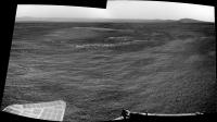
The Navcam L0 view on Sol 2670.
Jan van Driel
|
|
 |
 
|
|
|
Jul 30 2011, 07:10 PM
Post
#1187
|
|
|
Solar System Cartographer Group: Members Posts: 10166 Joined: 5-April 05 From: Canada Member No.: 227 |
We've been talking about this as if we had overestimated the height of Cape York (and we had), but now it looks as if we had underestimated the steepness of the slope down into Endeavour.
Phil -------------------- ... because the Solar System ain't gonna map itself.
Also to be found posting similar content on https://mastodon.social/@PhilStooke Maps for download (free PD: https://upload.wikimedia.org/wikipedia/comm...Cartography.pdf NOTE: everything created by me which I post on UMSF is considered to be in the public domain (NOT CC, public domain) |
|
|
|
| Guest_Sunspot_* |
Jul 30 2011, 07:22 PM
Post
#1188
|
|
Guests |
You really feel like you are looking into the bowl of a crater here:
http://marsrovers.jpl.nasa.gov/gallery/all...IP2375R2M8.HTML Also, any idea why there are so many data dropouts lately? |
|
|
|
|
Jul 30 2011, 07:40 PM
Post
#1189
|
||
 Senior Member Group: Members Posts: 4247 Joined: 17-January 05 Member No.: 152 |
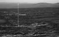
QUOTE (Phil Stooke @ Jul 30 2011, 07:10 PM)  it looks as if we had underestimated the steepness of the slope down into Endeavour. I estimated slopes of 5 or 6 degrees in Botany Bay based on pgrindrod's contour map, which still looks realistic. If we were looking down a 5.5 degree slope, the slope would appear this far below the distant (true) horizon in pancam:
So there's still a lot of room for the horizon to drop. My guess is in another few hundred metres, once we get a clear view down the throat of Botany Bay, the view will be really impressive (without Philovision!), and CY will actually turn out to be quite a dramatic "shelf". I hesitate saying all this since I could be wrong! The view will depend on what the slope does beyond CY. Anyway, we'll soon see... |
|
|
|
|
|
|
Jul 30 2011, 07:45 PM
Post
#1190
|
||
|
Senior Member Group: Members Posts: 2833 Joined: 22-April 05 From: Ridderkerk, Netherlands Member No.: 353 |
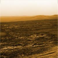
Here is the colourized version of that image for
better viewing of the slope. jan van driel
|
|
|
|
|
|
|
Jul 30 2011, 07:55 PM
Post
#1191
|
|
 Senior Member Group: Moderator Posts: 2262 Joined: 9-February 04 From: Melbourne - Oz Member No.: 16 |
For those of you not following me on Twitter two bits of news: Another ~65m drive tosol and that large ripple/dune/mound has been named 'Pathfinder Mound'
-------------------- |
|
|
|
|
Jul 30 2011, 08:28 PM
Post
#1192
|
|
 The Poet Dude Group: Moderator Posts: 5551 Joined: 15-March 04 From: Kendal, Cumbria, UK Member No.: 60 |
-------------------- |
|
|
|
|
Jul 30 2011, 08:40 PM
Post
#1193
|
||
|
The Poet Dude Group: Moderator Posts: 5551 Joined: 15-March 04 From: Kendal, Cumbria, UK Member No.: 60 |
Stretch view...
-------------------- |
|
|
|
|
|
|
Jul 30 2011, 08:42 PM
Post
#1194
|
|
|
Member Group: Members Posts: 146 Joined: 31-October 08 Member No.: 4473 |
Note that the "grain" of the cracks in the sediment now trend parallel to the rim of the crater. The boundaries of the covered-versus-uncovered areas also shows this trend. More extension perpendicular to the rim? Influence of buried topography? We are probably descending thought sediment layers too. The ground slope here is only 1-2 degrees. So far.
|
|
|
|
|
Jul 30 2011, 10:58 PM
Post
#1195
|
|
|
Junior Member Group: Members Posts: 98 Joined: 17-July 11 From: Pasadena, CA Member No.: 6066 |
QUOTE (Sunspot @ Jul 30 2011, 11:22 AM) You really feel like you are looking into the bowl of a crater here: http://marsrovers.jpl.nasa.gov/gallery/all...IP2375R2M8.HTML Also, any idea why there are so many data dropouts lately? "Data dropouts," meaning... what do you mean?  Combination of a few factors... 1) going into Restricted planning mode (as we do every couple weeks) 2) as it seems to me, smaller available relay downlink volumes through ODY and MRO (this is just bad luck, and perhaps there's some selection bias in my estimation) 3) longer latencies in the relayed downlink (again, bad luck) 4) dragons Mostly the dragons. Mostly. Though, again, it depends what you mean by "dropouts". |
|
|
|
|
Jul 30 2011, 11:08 PM
Post
#1196
|
|
|
Member Group: Members Posts: 194 Joined: 3-January 10 Member No.: 5156 |
Hi Matt!
I think he meant these black parts like here: http://marsrovers.jpl.nasa.gov/gallery/all...IP2375R2M7.HTML These parts just haven't been not been received on earth, and will be later send again. -------------------- Need more input ...
|
|
|
|
|
Jul 30 2011, 11:14 PM
Post
#1197
|
|
|
Junior Member Group: Members Posts: 98 Joined: 17-July 11 From: Pasadena, CA Member No.: 6066 |
QUOTE (MoreInput @ Jul 30 2011, 04:08 PM) Hi Matt! I think he meant these black parts like here: http://marsrovers.jpl.nasa.gov/gallery/all...IP2375R2M7.HTML These parts just haven't been not been received on earth, and will be later send again. Ohhh, that kind of dropout. Yup. It's a function of how they choose to prioritize the images and any sub-framing they do. |
|
|
|
|
Jul 30 2011, 11:39 PM
Post
#1198
|
|
|
Member Group: Members Posts: 194 Joined: 3-January 10 Member No.: 5156 |
Exploratorium up and running again...
-------------------- Need more input ...
|
|
|
|
|
Jul 31 2011, 12:03 AM
Post
#1199
|
|
 Senior Member Group: Members Posts: 1619 Joined: 12-February 06 From: Bergerac - FR Member No.: 678 |
Okay, this was already amazing. But now, this is going to be epic.
Sol 2671 pancam view 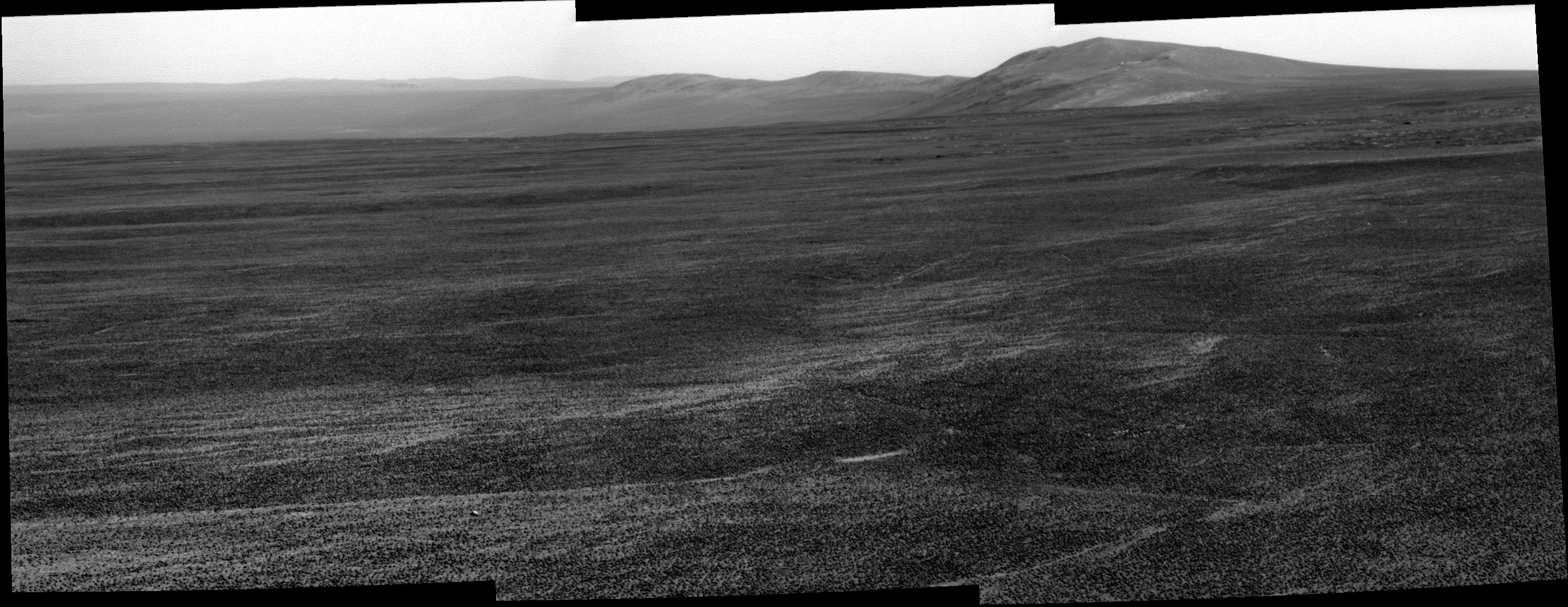 Also navcam, same sol : 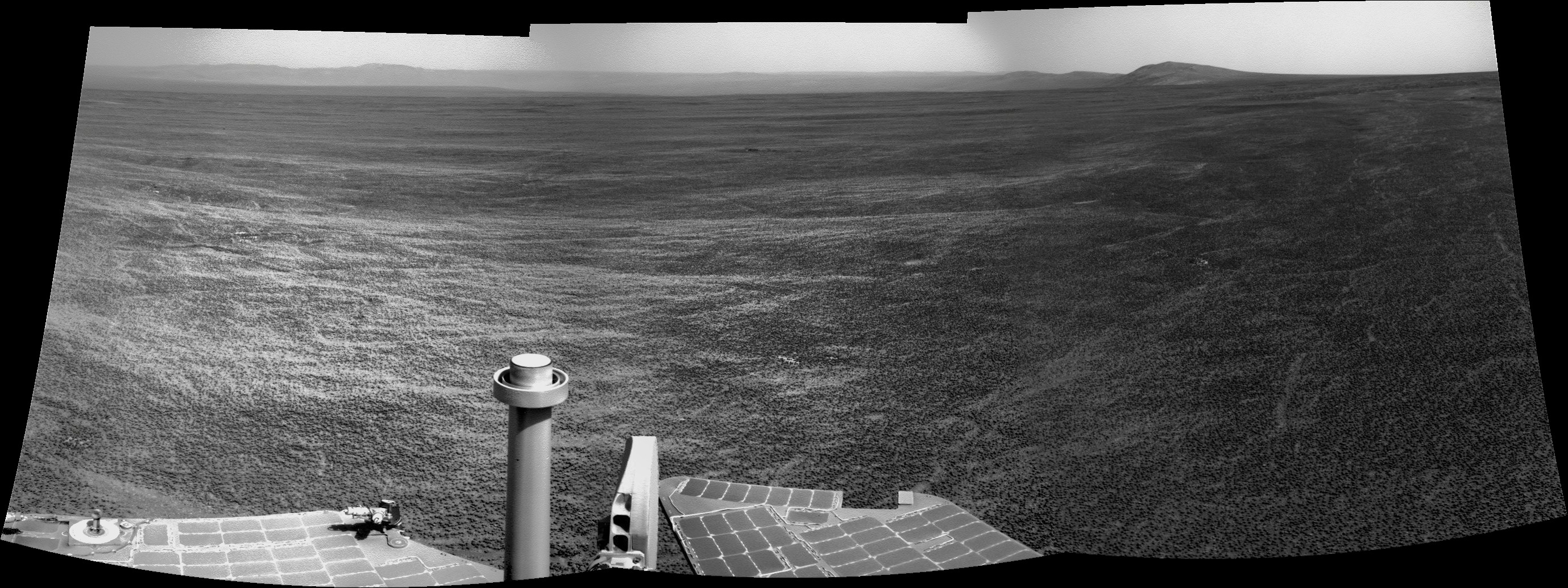 Cape York is now obviously visible on the left part of the pan. I just can't believe what we are living now  . .Ps : I will be a little bit out of networks the next week. I will try to continue working on pictures but not sure (internet through 3G network, in the Alps, it can be a little bit random). -------------------- |
|
|
|
|
Jul 31 2011, 12:05 AM
Post
#1200
|
||
|
Member Group: Members Posts: 194 Joined: 3-January 10 Member No.: 5156 |
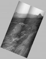
My first panorama, just removed most of the floor to see only the horizon.
Attached thumbnail(s)
-------------------- Need more input ...
|
|
|
|
|
|
|

|
Lo-Fi Version | Time is now: 23rd May 2024 - 10:55 AM |
|
RULES AND GUIDELINES Please read the Forum Rules and Guidelines before posting. IMAGE COPYRIGHT |
OPINIONS AND MODERATION Opinions expressed on UnmannedSpaceflight.com are those of the individual posters and do not necessarily reflect the opinions of UnmannedSpaceflight.com or The Planetary Society. The all-volunteer UnmannedSpaceflight.com moderation team is wholly independent of The Planetary Society. The Planetary Society has no influence over decisions made by the UnmannedSpaceflight.com moderators. |
SUPPORT THE FORUM Unmannedspaceflight.com is funded by the Planetary Society. Please consider supporting our work and many other projects by donating to the Society or becoming a member. |
|