Post Conjunction: Santa Maria to Cape York, The Journey to 'Spirit Point' |

  |
Post Conjunction: Santa Maria to Cape York, The Journey to 'Spirit Point' |
 Aug 7 2011, 06:05 AM Aug 7 2011, 06:05 AM
Post
#1411
|
||
 Member  Group: Members Posts: 691 Joined: 21-December 07 From: Clatskanie, Oregon Member No.: 3988 |
What a wonderful place!

|
|
 |
 
|
|
|
Aug 7 2011, 06:35 AM
Post
#1412
|
|
|
Member Group: Members Posts: 206 Joined: 15-August 07 From: Shrewsbury, Shropshire Member No.: 3233 |
QUOTE (ElkGroveDan @ Aug 7 2011, 02:43 AM)  Is it really that lumpy? Or is it an artifact of the anaglyph? If it is, it makes me wonder if the steering actuator might be an issue crossing that kind of relief, even driving backward. I could imagine one of Oppy's wheels getting stuck in a crevace between two rocks in this sort of landscape. I hope that the drivers go very carefully to Spirit point. It would be very tempting to me to attempt to drive to those inviting black rocks at Spirit Point in one SOL. Just imagine the first in-situ rocks other than Meridiani sediments that that Oppy has encountered in its entire mission look like they are only 100m away. |
|
|
|
|
Aug 7 2011, 06:55 AM
Post
#1413
|
|
|
Member Group: Members Posts: 362 Joined: 13-April 06 From: Malta Member No.: 741 |
So when is the final drive to Spirit point planned?
|
|
|
|
|
Aug 7 2011, 07:08 AM
Post
#1414
|
||
 The Poet Dude Group: Moderator Posts: 5551 Joined: 15-March 04 From: Kendal, Cumbria, UK Member No.: 60 |
Well, here we are...
-------------------- |
|
|
|
|
|
|
Aug 7 2011, 07:31 AM
Post
#1415
|
|
|
Member Group: Members Posts: 362 Joined: 13-April 06 From: Malta Member No.: 741 |
Not quite there....almost there...how high is that step onto Spirit point?
|
|
|
|
|
Aug 7 2011, 07:56 AM
Post
#1416
|
||
|
Senior Member Group: Members Posts: 2834 Joined: 22-April 05 From: Ridderkerk, Netherlands Member No.: 353 |
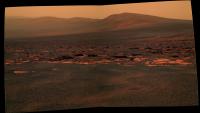
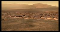
Sol 2678
The Navcam L0 view in colour. Jan van Driel
|
|
|
|
|
|
|
Aug 7 2011, 08:08 AM
Post
#1417
|
|
|
Member Group: Members Posts: 206 Joined: 15-August 07 From: Shrewsbury, Shropshire Member No.: 3233 |
QUOTE (Julius @ Aug 7 2011, 07:31 AM) Not quite there....almost there...how high is that step onto Spirit point? The rocks in Botany Bay were deposited next to the crater rim and so may feature interesting sedimentary structures. I guess that they will also need to be looked at in detail sooner or later. |
|
|
|
|
Aug 7 2011, 08:29 AM
Post
#1418
|
||
 Senior Member Group: Admin Posts: 3108 Joined: 21-December 05 From: Canberra, Australia Member No.: 615 |
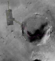
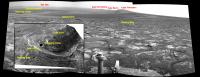
Just to put Opportunity's journey across Meridiani Planum from Eagle Crater to Endeavour Crater in some kind of context to the vistas we are seeing now.
Here's an image showing Opportunity's path (in yellow) and that same path (in purple) [in reverse] marked out across Endeavour Crater.
Opportunity and all of us have travelled far!  EDIT: Of course, the purple path doesn't take into account the topography, terrain and certainly not the last 7.5+ years of trials and triumphs. |
|
|
|
|
|
|
Aug 7 2011, 08:46 AM
Post
#1419
|
|
|
Member Group: Members Posts: 194 Joined: 3-January 10 Member No.: 5156 |
Let's drive 7 years long to the other side of the crater just to get a better view of Cape York
 ? ?
-------------------- Need more input ...
|
|
|
|
|
Aug 7 2011, 10:03 AM
Post
#1420
|
||
 Member Group: Members Posts: 810 Joined: 3-June 04 From: Brittany, France Member No.: 79 |
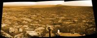
I have added the names of the places of interest on the Mick Navcam panorama. Please tell me if I'm wrong, and don't hesitate to add the position of the rover on the 3D view of Cape York.
Attached thumbnail(s)
-------------------- |
|
|
|
|
|
|
Aug 7 2011, 10:07 AM
Post
#1421
|
|
|
Member Group: Members Posts: 362 Joined: 13-April 06 From: Malta Member No.: 741 |
I'v been tryimg to look for crism data of CY. Could someone post a link? Thanks
|
|
|
|
|
Aug 7 2011, 10:17 AM
Post
#1422
|
||
|
Member Group: Members Posts: 810 Joined: 3-June 04 From: Brittany, France Member No.: 79 |
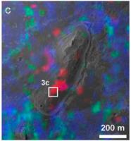
QUOTE (Julius @ Aug 7 2011, 10:07 AM) I'v been tryimg to look for crism data of CY. Could someone post a link? Thanks There is a paper of Wray et al. (2009) published in Geophysical Research Letters where the distribution of phyllosilicates and sulfates on Cape York is shown, retrieved from a CRISM observation. Red is for Fe/Mg-phyllosilicates and cyan is for polyhydrated sulfates.
Attached thumbnail(s)
-------------------- |
|
|
|
|
|
|
Aug 7 2011, 12:16 PM
Post
#1423
|
||
|
The Poet Dude Group: Moderator Posts: 5551 Joined: 15-March 04 From: Kendal, Cumbria, UK Member No.: 60 |
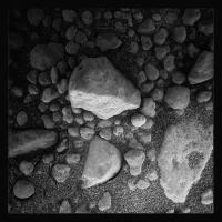
A lone, lonely MI image came down overnight... tweaked it a bit...
-------------------- |
|
|
|
|
|
|
Aug 7 2011, 12:22 PM
Post
#1424
|
|
|
Member Group: Members Posts: 362 Joined: 13-April 06 From: Malta Member No.: 741 |
Thanks neo for that..I was wondering at which point along CY would oppy get to sniff phylosilicates.
|
|
|
|
|
Aug 7 2011, 01:31 PM
Post
#1425
|
|
|
Newbie Group: Members Posts: 13 Joined: 6-April 09 Member No.: 4720 |
QUOTE (Astro0 @ Aug 7 2011, 03:29 AM) Just to put Opportunity's journey across Meridiani Planum from Eagle Crater to Endeavour Crater in some kind of context to the vistas we are seeing now. Here's an image showing Opportunity's path (in yellow) and that same path (in purple) [in reverse] marked out across Endeavour Crater. Opportunity and all of us have travelled far! EDIT: Of course, the purple path doesn't take into account the topography, terrain and certainly not the last 7.5+ years of trials and triumphs. Looking at that image makes me remember comments regarding not worrying too much about getting stuck in Endurance crater, since it was a great place to study, and that was about as long as the mission would last anyhow. |
|
|
|
|

|
Lo-Fi Version | Time is now: 25th May 2024 - 06:21 AM |
|
RULES AND GUIDELINES Please read the Forum Rules and Guidelines before posting. IMAGE COPYRIGHT |
OPINIONS AND MODERATION Opinions expressed on UnmannedSpaceflight.com are those of the individual posters and do not necessarily reflect the opinions of UnmannedSpaceflight.com or The Planetary Society. The all-volunteer UnmannedSpaceflight.com moderation team is wholly independent of The Planetary Society. The Planetary Society has no influence over decisions made by the UnmannedSpaceflight.com moderators. |
SUPPORT THE FORUM Unmannedspaceflight.com is funded by the Planetary Society. Please consider supporting our work and many other projects by donating to the Society or becoming a member. |
|