Post Conjunction: Santa Maria to Cape York, The Journey to 'Spirit Point' |

  |
Post Conjunction: Santa Maria to Cape York, The Journey to 'Spirit Point' |
 Aug 9 2011, 04:51 AM Aug 9 2011, 04:51 AM
Post
#1486
|
|
 Senior Member  Group: Members Posts: 2228 Joined: 1-December 04 From: Marble Falls, Texas, USA Member No.: 116 |
QUOTE (MoreInput @ Aug 8 2011, 02:58 AM)  I made with Google Mars a cross section through the east crater rim from Cape York to Cape Byron. ... While the Google Earth elevation profile tool is quite useful, you must be careful using it on Mars. The Google Mars elevations are not accurate in areas where elevations change more rapidly than the MOLA shot point coverage does.-------------------- ...Tom
I'm not a Space Fan, I'm a Space Exploration Enthusiast. |
 |
 
|
|
Aug 9 2011, 05:33 AM
Post
#1487
|
|
 Senior Member Group: Members Posts: 4247 Joined: 17-January 05 Member No.: 152 |
Nice job with those identifications, John. Things are definitely getting clearer...
From Maxwell: QUOTE The drive we uplink today will actually take us physically onto Cape York. So. *Freaking*. Excited.   
|
|
|
|
|
Aug 9 2011, 07:24 AM
Post
#1488
|
||
|
Senior Member Group: Members Posts: 2835 Joined: 22-April 05 From: Ridderkerk, Netherlands Member No.: 353 |
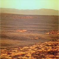
The complete colourized navcam view of Endeavour Crater on
Sol 2679. Jan van Driel
|
|
|
|
|
|
|
Aug 9 2011, 07:30 AM
Post
#1489
|
|
|
Junior Member Group: Members Posts: 52 Joined: 1-March 11 From: Houston, USA Member No.: 5860 |
QUOTE (MoreInput @ Aug 8 2011, 01:21 AM) Did Oppy or even Spirit found such boulders (> 1,50 meters)? I don't think so we have seen such big thing yet in the last 8 years. You may be right. I thought Wopmay in Endurance might be that big, but Wopmay was only a meter or so across, though other rocks near it may have been larger. Which makes the boulders near Odyssey all the more interesting, because they appear to be in a location that's more prone to wind-driven erosion than the interior of Endurance. |
|
|
|
| Guest_Bobby_* |
Aug 9 2011, 08:02 AM
Post
#1490
|
|
Guests |
I have a Question?
I know how important it is for Opportunity to find phyllosilicates at Cape York on Mars but has any rover or any orbiting Satellite ever found any rare Metals like Gold, Silver etc. I've all ways wondered if Mars does have any rare metals? I would also like to say Thanks to all the image wizards in UMSF for doing such a Great Job. I love reading all the posts members put in here. Just a fan watching this amazing time for Opportunity. The flux capacitor on Oppy must be reading Full right now. Take Care, Bobby |
|
|
|
|
Aug 9 2011, 08:34 AM
Post
#1491
|
|
 Member Group: Members Posts: 691 Joined: 21-December 07 From: Clatskanie, Oregon Member No.: 3988 |
As far as I know, the rovers arn't capable of detecting any precious metals like gold or silver. Please correct me if I'm wrong though. APXS can detect elements like aluminium, iron, nickel, sodium, magnesium, titanium, silicon, calcium, chlorine, and some other elements possibly carbon and oxygen I believe.
|
|
|
|
|
Aug 9 2011, 09:12 AM
Post
#1492
|
||
 Member Group: Members Posts: 648 Joined: 9-May 05 From: Subotica Member No.: 384 |
Single color (L257) image from sol2667 has seen the light of day on Exploratorium.
3 images are from this sequence: QUOTE 02667 p2373.28 6 0 0 5 1 12 pancam_Endeavour_rim_2x1_L257
Crater on far wall of Endeavour can still be seen, unlike now. -------------------- The scientist does not study nature because it is useful; he studies it because he delights in it, and he delights in it because it is beautiful.
Jules H. Poincare My "Astrophotos" gallery on flickr... |
|
|
|
|
|
|
Aug 9 2011, 09:30 AM
Post
#1493
|
|
|
Senior Member Group: Moderator Posts: 4279 Joined: 19-April 05 From: .br at .es Member No.: 253 |
That's due to the increment on tau on this latest sols, I think.
|
|
|
|
|
Aug 9 2011, 11:15 AM
Post
#1494
|
|
|
Forum Contributor Group: Members Posts: 1372 Joined: 8-February 04 From: North East Florida, USA. Member No.: 11 |
Where are are going after Cape York ?
I've been confused for a week or two as I was expecting Cape York to be a big hill, it's like a gentle rise really. I just realised today that that's Endeavour Crater in the distance.  QUOTE (fredk @ Aug 8 2011, 05:58 AM) First conclusion: the step up to CY is really tiny! That's exactly what confused me. |
|
|
|
|
Aug 9 2011, 12:13 PM
Post
#1495
|
|
|
Member Group: Members Posts: 362 Joined: 13-April 06 From: Malta Member No.: 741 |
The Endeavour central mound looks to me like its a windblown basaltic sand dune like el dorado at spirits site...i'm not seeing any layering there....besides it seems to be too dusty and dangerous for Oppy to drive on it...most likely it will get stuck just as it did at purgatory!
|
|
|
|
|
Aug 9 2011, 12:14 PM
Post
#1496
|
|
|
Member Group: Members Posts: 315 Joined: 1-October 06 Member No.: 1206 |
Hmmm, Oppy could be doing good 'steal her thunder' work on that central mound before Curiosity arrives at Gale!
 P |
|
|
|
|
Aug 9 2011, 01:02 PM
Post
#1497
|
|
 Senior Member Group: Admin Posts: 3108 Joined: 21-December 05 From: Canberra, Australia Member No.: 615 |
I expect we'll be watching Oppy working around the rim for quite some time.
That crater down there is her entire 7.5 year journey laid out in front of us. That central mound is a long way off and with a lot of ground inbetween. And please don't even think about talking Iazu. First job, characterise the geology, lock down the phyllosilicates and then sniff out what else we can find out about Mars' past enivronmental conditions. That's a prime mission right there. |
|
|
|
|
Aug 9 2011, 01:04 PM
Post
#1498
|
|
 Senior Member Group: Members Posts: 2173 Joined: 28-December 04 From: Florida, USA Member No.: 132 |
QUOTE (Julius @ Aug 9 2011, 08:13 AM) The Endeavour central mound looks to me like its a windblown basaltic sand dune.... My opinion (a two cent value!) is that the mound is the same built up sulphate layers that surround Endeavour and cover all of Meridiani that Opportunity has traversed. The reason it is a mound is because wind patterns, influenced by the crater rim, have eroded away more of the material filling the crater near the crater rim, leaving more in the center.
|
|
|
|
|
Aug 9 2011, 01:26 PM
Post
#1499
|
|
|
Junior Member Group: Members Posts: 98 Joined: 17-July 11 From: Pasadena, CA Member No.: 6066 |
QUOTE (Toma B @ Aug 8 2011, 12:07 AM) Just for fun. Final part of that GIF series centered roughly on Cape Tribulation. It is Philovisioned drive direction panoramas after sols 2671,2674,2676 and 2678. [attachment=25157:Sol_2671...o_deform.gif] It can clearly be seen that last drive (sol 2678) was shorter. Also, since the Endeavour crater "opened" there is no point in making this GIF. If we start moving towards Cape Trib. once I will try to continue this series. By the way, this GIF has been placed in the LTP reports at our SOWG meetings both Friday and Monday. I forwarded it on to the team Friday morning, and it got everyone's attention. It is referred to as the "now infamous UMSF .gif"! -m |
|
|
|
|
Aug 9 2011, 01:30 PM
Post
#1500
|
|
 Member Group: Members Posts: 656 Joined: 20-April 05 From: League City, Texas Member No.: 285 |
With regard to the layering in the central mound and edges of Endeavour, for years (since I first advocated that Oppy head this way and was laughed at for such a crazily ambitious notion), it has made sense to me that many of these features were neatly interpretable as remnant "beaches" and other associated features from an evaporating ice-covered lake which once filled the crater. This may be a bit of a stretch, but it seems reasonable to me that, if the plains were saturated by groundwater (which appears to be the case), then the lower altitude Endeavour ought to be filled with water. What I don't see is flow features, so if this notion is correct, the source of the water would have been entirely groundwater seeping through permeable geology.
|
|
|
|
|

|
Lo-Fi Version | Time is now: 26th May 2024 - 05:38 PM |
|
RULES AND GUIDELINES Please read the Forum Rules and Guidelines before posting. IMAGE COPYRIGHT |
OPINIONS AND MODERATION Opinions expressed on UnmannedSpaceflight.com are those of the individual posters and do not necessarily reflect the opinions of UnmannedSpaceflight.com or The Planetary Society. The all-volunteer UnmannedSpaceflight.com moderation team is wholly independent of The Planetary Society. The Planetary Society has no influence over decisions made by the UnmannedSpaceflight.com moderators. |
SUPPORT THE FORUM Unmannedspaceflight.com is funded by the Planetary Society. Please consider supporting our work and many other projects by donating to the Society or becoming a member. |
|