Cape York - Shoemaker Ridge and the NE traverse, Starting sol 2735 |

  |
Cape York - Shoemaker Ridge and the NE traverse, Starting sol 2735 |
 Nov 17 2011, 11:01 AM Nov 17 2011, 11:01 AM
Post
#481
|
|
 Senior Member  Group: Members Posts: 1089 Joined: 19-February 05 From: Close to Meudon Observatory in France Member No.: 172 |
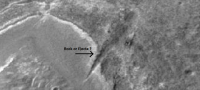
... and it seems that there are some layerings visible inside the "walls" of the Dagger. An interesting feature indeed !

|
 |
 
|
|
Nov 17 2011, 11:06 AM
Post
#482
|
|
|
Senior Member Group: Members Posts: 1089 Joined: 19-February 05 From: Close to Meudon Observatory in France Member No.: 172 |
QUOTE (Ant103 @ Nov 17 2011, 12:30 AM)  Sol 2777 (check my trips). We can see the North corner of CY, no ? ...and look at the low-gain antenna mast : so dusty now. With even some clods of dust/dirt sticking on it ! 
|
|
|
|
|
Nov 17 2011, 11:56 AM
Post
#483
|
||
|
Senior Member Group: Members Posts: 2998 Joined: 30-October 04 Member No.: 105 |
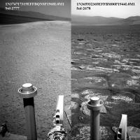
Indeed, VM. I've been following the "antenna dust" phenomenon for several years.
Here are images from Sol-2678 (June 2011) and Sol-2777 (November 2011) showing how much the dust has increased in just 100 Sols. This makes sense. Cape York is actively weathering and eroding and the light winds available in this season are enough to suspend fine dust particles so that they can adhere to the antenna. As the season moves on, we will hopefully get gustier transient winds, which will lead to a cleaning event. --Bill
Attached thumbnail(s)
-------------------- |
|
|
|
|
|
|
Nov 17 2011, 08:51 PM
Post
#484
|
||
|
Senior Member Group: Moderator Posts: 4279 Joined: 19-April 05 From: .br at .es Member No.: 253 |
The navcam images shot after today's (2778) drive are available here (http://qt.exploratorium.edu/mars/opportuni...cam/2011-11-17/) and it looks like we are almost at the summit (if we can call it this way). The view should be great BUT unfortunately all ìmages were intentionally taken pointing down so the horizon is out of the FoV.
Edit: Added a quick navcam mosaic pointing south to what I presume is "Turkey Haven".
|
|
|
|
|
|
|
Nov 17 2011, 09:12 PM
Post
#485
|
|
|
Senior Member Group: Members Posts: 2998 Joined: 30-October 04 Member No.: 105 |
The horizon is simply not important right now. The important areas are at our feet.
We do have a nice L257 of "Turkey Haven", though. I'm going to miss my informal name for it-- "Gracie Peak, a major structural feature of the Allen Formation". --Bill -------------------- |
|
|
|
|
Nov 17 2011, 10:13 PM
Post
#486
|
|
|
Senior Member Group: Members Posts: 3516 Joined: 4-November 05 From: North Wales Member No.: 542 |
QUOTE (Bill Harris @ Nov 17 2011, 09:12 PM) The horizon is simply not important right now How can anybody say that? Geologists... - I don't know. (huff, puff) I give up.  PS I think we'll get plenty of horizon in due course, maybe an opportunity for a long baseline pancam 3D of Cook and friends?? |
|
|
|
|
Nov 18 2011, 12:12 AM
Post
#487
|
|
 Senior Member Group: Members Posts: 1619 Joined: 12-February 06 From: Bergerac - FR Member No.: 678 |
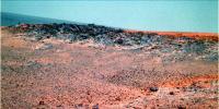
The horizon is important IMO
 . But yet, sometimes you have to made concessions when imaging an outcrop like this. . But yet, sometimes you have to made concessions when imaging an outcrop like this.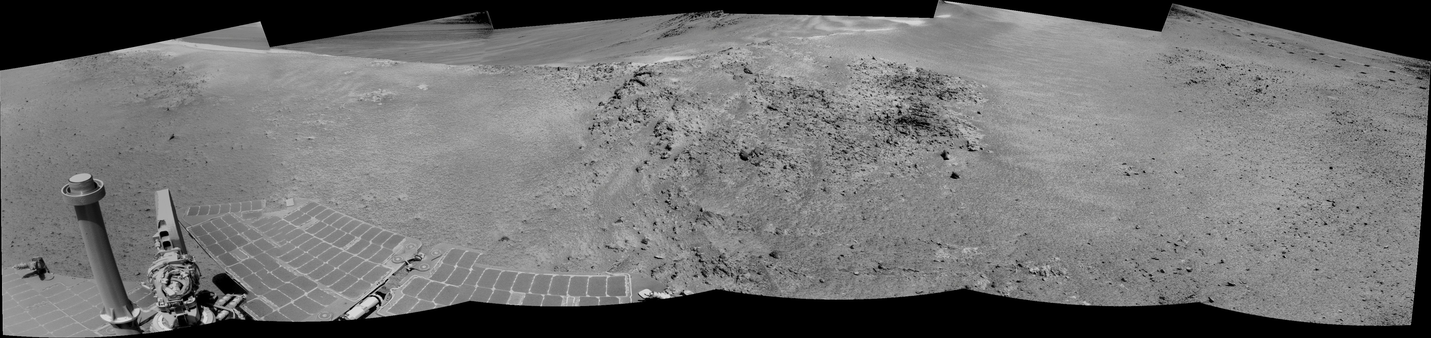 And a little color ? 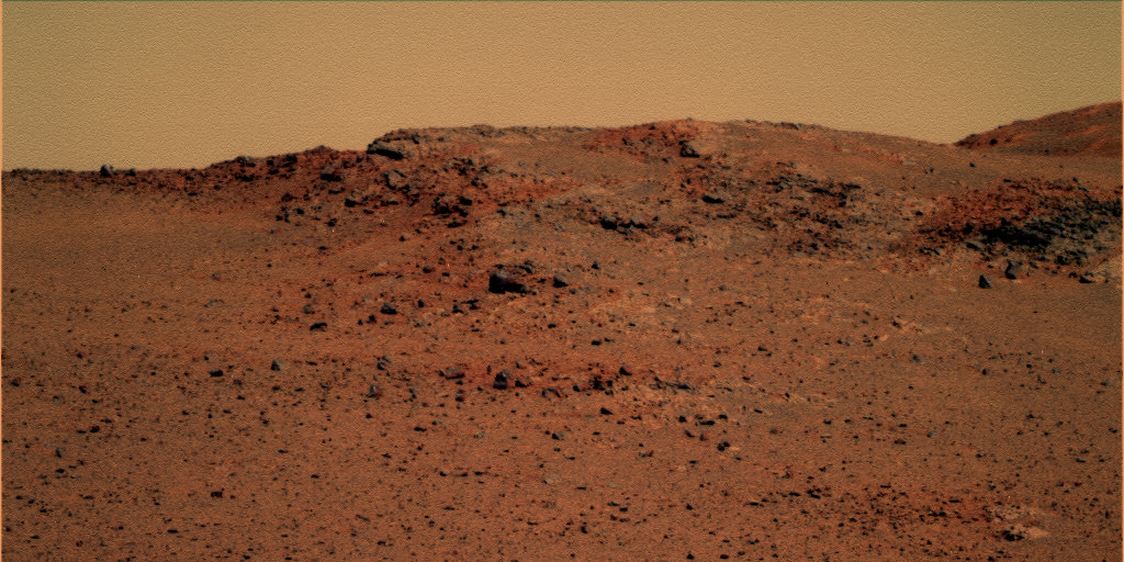
-------------------- |
|
|
|
|
Nov 18 2011, 12:12 AM
Post
#488
|
||
|
Junior Member Group: Members Posts: 98 Joined: 17-July 11 From: Pasadena, CA Member No.: 6066 |
QUOTE (Tesheiner @ Nov 17 2011, 12:51 PM) The navcam images shot after today's (2778) drive are available here (http://qt.exploratorium.edu/mars/opportuni...cam/2011-11-17/) and it looks like we are almost at the summit (if we can call it this way). The view should be great BUT unfortunately all ìmages were intentionally taken pointing down so the horizon is out of the FoV. Edit: Added a quick navcam mosaic pointing south to what I presume is "Turkey Haven".
Right. So. We're currently sitting on a locally north-titled dip right before this little mound in front of us. Tilt is between 5 and 10 degrees, I don't know exactly. We're going to recon this hill to our south and then the same ridge, about 15 meters away, a little more to the East. The hill to our south is Turkey Haven -- where we might stay for the long Thanksgiving weekend -- with a north tilt of about 15 degrees; the one that's more to the east on the same ridge is one of the highest northerly tilted areas on all of Cape York. I don't know if there's a target associated with that one yet. We've got a bit more mapping to do of other parts, but these spots look very promising to come back to once we're done mapping and roving around for some science. -m |
|
|
|
|
|
|
Nov 18 2011, 12:48 AM
Post
#489
|
|||
|
Senior Member Group: Members Posts: 2998 Joined: 30-October 04 Member No.: 105 |
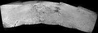
And here is the half-frame L257 of Turkey Haven on Sol-2778 (P2430).
The first thought that most geologists would have seeing colors like these is "Whoa, this is deeply weathered". --Bill EDIT-- added a L257 of North Haven on Sol-2778 (P2431) that came in later.
Attached thumbnail(s)
-------------------- |
||
|
|
|
||
|
Nov 18 2011, 02:03 AM
Post
#490
|
||
|
Member Group: Members Posts: 808 Joined: 10-October 06 From: Maynard Mass USA Member No.: 1241 |
(Hey Bill, that blue sky makes it look like Arizona! Nice!)
As we anticipate the 'reveal' of the unique dagger formation (just over the hill) I noticed a rock at the edge of the skirt of CY at the mouth of the dagger. I can't remember seeing exposed large rocks at the skirt's edge -- that weren't related to a nearby crater (and if my poor memory is faulty- I am sure some one will 'remind' me ) Anyway, could the rock have had some hand in making the (shallow) trench and aeolian erosion did the rest??
-------------------- CLA CLL
|
|
|
|
|
|
|
Nov 18 2011, 03:36 AM
Post
#491
|
|
|
Member Group: Members Posts: 507 Joined: 10-September 08 Member No.: 4338 |
QUOTE (PDP8E @ Nov 17 2011, 06:03 PM) ... could the rock have had some in hand making the (shallow) trench and aeolian erosion did the rest?? Hmm. If the wind is being funneled through the dagger formation, then that might be a place to get a solar panel cleaning?  Of course, conditions may have changed since then. Of course, conditions may have changed since then.
|
|
|
|
|
Nov 18 2011, 05:04 AM
Post
#492
|
|
 Senior Member Group: Admin Posts: 4763 Joined: 15-March 05 From: Glendale, AZ Member No.: 197 |
QUOTE (Matt Lenda @ Nov 17 2011, 04:12 PM) Turkey Haven -- where we might stay for the long Thanksgiving weekend Does that mean we can expect a location called "Santa's Workshop" a month from now? -------------------- If Occam had heard my theory, things would be very different now.
|
|
|
|
|
Nov 18 2011, 05:20 AM
Post
#493
|
||
|
Senior Member Group: Members Posts: 2998 Joined: 30-October 04 Member No.: 105 |
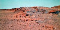
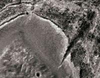
Here, for comparison, is a different view of the same HiRISE image. This has been processed to emphasize small, low contrast features so it looks rather chunky compared to PDP's image.
The Dagger is emigmatic, to be sure. It looks like it is a water-related erosinal feature, but given it's locale has to be an aeolian feature. And notice the way it fans out to the NE-- almost like a slope failure/landslide. It has to be fairly recent-- look at the sharp rock ledges along it's margins. And notice the similar, but less evolved, feature on the left side of these images. My speculation is that the Dagger is an area of weak, less-resistant bedrock (in a fracture zone, for example) and the rocks are more prone to wind erosion. Or instead of fractures, the rock is lithologically different because this is an old paleo land surface that is early- or pre-Endeavor and is a different rock type. Whatever it is, it will make for good science. --Bill
Attached thumbnail(s)
-------------------- |
|
|
|
|
|
|
Nov 18 2011, 06:20 AM
Post
#494
|
|
 Senior Member Group: Members Posts: 2228 Joined: 1-December 04 From: Marble Falls, Texas, USA Member No.: 116 |
QUOTE (Bill Harris @ Nov 17 2011, 06:48 PM) ... The first thought that most geologists would have seeing colors like these is "Whoa, this is deeply weathered". ... Those colors certainly caught my attention and had me thinking, "Whoa!" But, I am not sure it is deeply weathered. The iron oxidation that is surely causing those color contrasts seems not to be related to weathering surfaces, but rather to some other structures internal to this outcrop. I'd go so far as to say the outcrop is deeply altered. I'll admit, though, that weathering often follows planes of weakness, and that this first view of the outcrop could be tricky to interpret. I can't wait to see some higher resolution images of these rocks. How about that vein or dike in the drive direction pancams to the left of turkey haven? I'm looking forward to seeing that in higher res. -------------------- ...Tom
I'm not a Space Fan, I'm a Space Exploration Enthusiast. |
|
|
|
|
Nov 18 2011, 07:49 AM
Post
#495
|
|
|
Senior Member Group: Moderator Posts: 4279 Joined: 19-April 05 From: .br at .es Member No.: 253 |
QUOTE (Matt Lenda @ Nov 18 2011, 01:12 AM) <...> We've got a bit more mapping to do of other parts, but these spots look very promising to come back to once we're done mapping and roving around for some science. Thanks for the info and for your yesterday's blog entry too, Matt. Note to everyone: check that blog; it has a lot of "goodies". |
|
|
|
|

|
Lo-Fi Version | Time is now: 29th May 2024 - 04:27 PM |
|
RULES AND GUIDELINES Please read the Forum Rules and Guidelines before posting. IMAGE COPYRIGHT |
OPINIONS AND MODERATION Opinions expressed on UnmannedSpaceflight.com are those of the individual posters and do not necessarily reflect the opinions of UnmannedSpaceflight.com or The Planetary Society. The all-volunteer UnmannedSpaceflight.com moderation team is wholly independent of The Planetary Society. The Planetary Society has no influence over decisions made by the UnmannedSpaceflight.com moderators. |
SUPPORT THE FORUM Unmannedspaceflight.com is funded by the Planetary Society. Please consider supporting our work and many other projects by donating to the Society or becoming a member. |
|