MSL landing site: Gale Crater |

  |
MSL landing site: Gale Crater |
 Jul 17 2012, 07:43 PM Jul 17 2012, 07:43 PM
Post
#151
|
|
|
Solar System Cartographer  Group: Members Posts: 10153 Joined: 5-April 05 From: Canada Member No.: 227 |
Leave a few for us!
Phil -------------------- ... because the Solar System ain't gonna map itself.
Also to be found posting similar content on https://mastodon.social/@PhilStooke Maps for download (free PD: https://upload.wikimedia.org/wikipedia/comm...Cartography.pdf NOTE: everything created by me which I post on UMSF is considered to be in the public domain (NOT CC, public domain) |
 |
 
|
|
Jul 17 2012, 07:56 PM
Post
#152
|
|
 Senior Member Group: Members Posts: 1465 Joined: 9-February 04 From: Columbus OH USA Member No.: 13 |
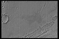
QUOTE (Phil Stooke @ Jul 17 2012, 10:12 AM)  This is a full resolution - but quite compressed - CTX mosaic of the ellipse area. Phil [attachment=27059:gale_ell...op_small.jpg] Is an image available at full CTX resolution but of the entire Gale Crater? How about HiRISE resolution of the ellipse or larger area? I'm thinking of something suitable for printing very large. -------------------- |
|
|
|
|
Jul 17 2012, 08:22 PM
Post
#153
|
|
|
Solar System Cartographer Group: Members Posts: 10153 Joined: 5-April 05 From: Canada Member No.: 227 |
Not yet! (yes, the images exist, but no, not yet available mosaicked for download). But I expect so later from someone other than me. Those would be BIG files.
Phil -------------------- ... because the Solar System ain't gonna map itself.
Also to be found posting similar content on https://mastodon.social/@PhilStooke Maps for download (free PD: https://upload.wikimedia.org/wikipedia/comm...Cartography.pdf NOTE: everything created by me which I post on UMSF is considered to be in the public domain (NOT CC, public domain) |
|
|
|
|
Jul 17 2012, 08:27 PM
Post
#154
|
||
 The Poet Dude Group: Moderator Posts: 5551 Joined: 15-March 04 From: Kendal, Cumbria, UK Member No.: 60 |
Phil,
Hope you don't mind, I took your great pic and put the landing ellipse over it (taken from one of the pics shown at yesterday's press event).
Busy place... (Doesn't line up perfectly, I know, some ghosting here n there but just meant as a rough guide...) -------------------- |
|
|
|
|
|
|
Jul 17 2012, 08:56 PM
Post
#155
|
|
|
Solar System Cartographer Group: Members Posts: 10153 Joined: 5-April 05 From: Canada Member No.: 227 |
That's what it's for!
There's a lot going on. As they said at the briefing, there should be some alluvial deposits derived from the crater walls in the middle of the ellipse. I'm impatient for some more placenames now! Phil -------------------- ... because the Solar System ain't gonna map itself.
Also to be found posting similar content on https://mastodon.social/@PhilStooke Maps for download (free PD: https://upload.wikimedia.org/wikipedia/comm...Cartography.pdf NOTE: everything created by me which I post on UMSF is considered to be in the public domain (NOT CC, public domain) |
|
|
|
|
Jul 17 2012, 09:17 PM
Post
#156
|
|
|
Member Group: Admin Posts: 976 Joined: 29-September 06 From: Pasadena, CA - USA Member No.: 1200 |
QUOTE (jmknapp @ Jul 17 2012, 12:56 PM) Is an image available at full CTX resolution but of the entire Gale Crater? How about HiRISE resolution of the ellipse or larger area? I'm thinking of something suitable for printing very large. These are all the HiRISE images that I have analyzed for traversability. If you go to the HiRISE server that lists all the DTMs http://hirise.lpl.arizona.edu/dtm/ you can download the DTMs and orthophotos for both "eyes". I stitched them together pretty easily just applying a horizontal and vertical offset. My 1mpp mosaic is about 30000x46250 pixels. Managing the mosaic at .25mpp proved to be a bit cumbersome. ESP_011562_1755 ESP_012551_1750 ESP_018854_1755 ESP_019698_1750 ESP_023957_1755 ESP_024102_1755 ESP_024102_175N ESP_024234_1755 PSP_001488_1750 PSP_009294_1750 PSP_009505_1755 PSP_009716_1755 PSP_010573_1755 There are some additional HiRISE mono images but I don't have a full list but I can find out if anyone is interested. Paolo -------------------- Disclaimer: all opinions, ideas and information included here are my own,and should not be intended to represent opinion or policy of my employer.
|
|
|
|
|
Jul 17 2012, 09:22 PM
Post
#157
|
|
|
Member Group: Admin Posts: 976 Joined: 29-September 06 From: Pasadena, CA - USA Member No.: 1200 |
QUOTE (akuo @ Jul 17 2012, 12:22 PM) Has there been any study of the traversability of those dunes in the southeast? I did. Those dunes are oriented mostly SW to NE and the slopes between crests are relatively benign. The tests we have done using Scarecrow both at Dumont Dunes and in the Mars Yard show that we should be able to navigate through them. While there are areas with steep slopes the vehicle should be able to drive off of them and reach a gradual slope. In short, there are no rover traps there. Paolo -------------------- Disclaimer: all opinions, ideas and information included here are my own,and should not be intended to represent opinion or policy of my employer.
|
|
|
|
|
Jul 17 2012, 10:15 PM
Post
#158
|
|
|
Junior Member Group: Members Posts: 89 Joined: 27-August 05 From: Eccentric Mars orbit Member No.: 477 |
Several minutes of google did not reveal the coordinates and orientation of the new landing ellipse (or old one for that matter). Could someone please post those coordinates?
|
|
|
|
|
Jul 17 2012, 10:41 PM
Post
#159
|
|
 Senior Member Group: Admin Posts: 3108 Joined: 21-December 05 From: Canberra, Australia Member No.: 615 |
|
|
|
|
|
Jul 17 2012, 11:46 PM
Post
#160
|
|
 Member Group: Members Posts: 131 Joined: 31-May 08 From: San Carlos, California, USA Member No.: 4168 |
Re: The pic Stu posted with the target ellipse.
Will MSL be coming in W-to-E, or E-to-W? I'm assuming N is "up" in that pic. |
|
|
|
|
Jul 18 2012, 12:00 AM
Post
#161
|
|
|
Solar System Cartographer Group: Members Posts: 10153 Joined: 5-April 05 From: Canada Member No.: 227 |
North is always up in anything I do, unless I forgot...
Phil -------------------- ... because the Solar System ain't gonna map itself.
Also to be found posting similar content on https://mastodon.social/@PhilStooke Maps for download (free PD: https://upload.wikimedia.org/wikipedia/comm...Cartography.pdf NOTE: everything created by me which I post on UMSF is considered to be in the public domain (NOT CC, public domain) |
|
|
|
|
Jul 18 2012, 12:14 AM
Post
#162
|
|
|
Founder Group: Chairman Posts: 14432 Joined: 8-February 04 Member No.: 1 |
QUOTE (Syrinx @ Jul 17 2012, 03:46 PM) Will MSL be coming in W-to-E, or E-to-W? From the west, travelling east. The press kit includes that info "While descending from that altitude to the surface, the spacecraft will also be traveling eastward relative to the Mars surface, covering a ground-track distance of about 390 miles (about 630 kilometers) between the atmospheric entry point and the touchdown target." Astro0 just linked to it - I'll link to it again - http://mars.jpl.nasa.gov/msl/news/pdfs/MSLLanding.pdf |
|
|
|
|
Jul 18 2012, 01:16 AM
Post
#163
|
|
|
Member Group: Admin Posts: 976 Joined: 29-September 06 From: Pasadena, CA - USA Member No.: 1200 |
QUOTE (Phil Stooke @ Jul 17 2012, 05:00 PM) North is always up in anything I do, unless I forgot... Phil Phil, your mosaic looks correct but the ellipse major axis that Stu added seems quite off. I think it is 87-89 deg from North, this one looks more like > 90 deg to me. And yes, MSL will be flying West to East. Paolo -------------------- Disclaimer: all opinions, ideas and information included here are my own,and should not be intended to represent opinion or policy of my employer.
|
|
|
|
|
Jul 18 2012, 02:42 AM
Post
#164
|
|
|
Solar System Cartographer Group: Members Posts: 10153 Joined: 5-April 05 From: Canada Member No.: 227 |
I should be more specific and say that north is close to 'up' in this image, but it's still in its raw image orientation and has not been aligned exactly with north. But at least it's not east up or south up...
Phil -------------------- ... because the Solar System ain't gonna map itself.
Also to be found posting similar content on https://mastodon.social/@PhilStooke Maps for download (free PD: https://upload.wikimedia.org/wikipedia/comm...Cartography.pdf NOTE: everything created by me which I post on UMSF is considered to be in the public domain (NOT CC, public domain) |
|
|
|
|
Jul 18 2012, 04:00 AM
Post
#165
|
|
 Senior Member Group: Members Posts: 4246 Joined: 17-January 05 Member No.: 152 |
QUOTE (RoverDriver @ Jul 18 2012, 01:16 AM) And yes, MSL will be flying West to East. Less braking is needed when they come in from W to E (with the planet's rotation) compared to E to W (against the rotation). I don't know for sure if that's the reason, but I'd definitely wager a Mars bar on it! |
|
|
|
|

|
Lo-Fi Version | Time is now: 28th April 2024 - 05:27 AM |
|
RULES AND GUIDELINES Please read the Forum Rules and Guidelines before posting. IMAGE COPYRIGHT |
OPINIONS AND MODERATION Opinions expressed on UnmannedSpaceflight.com are those of the individual posters and do not necessarily reflect the opinions of UnmannedSpaceflight.com or The Planetary Society. The all-volunteer UnmannedSpaceflight.com moderation team is wholly independent of The Planetary Society. The Planetary Society has no influence over decisions made by the UnmannedSpaceflight.com moderators. |
SUPPORT THE FORUM Unmannedspaceflight.com is funded by the Planetary Society. Please consider supporting our work and many other projects by donating to the Society or becoming a member. |
|