MSL landing site: Gale Crater |

  |
MSL landing site: Gale Crater |
 Jul 18 2012, 07:37 AM Jul 18 2012, 07:37 AM
Post
#166
|
|
 The Poet Dude  Group: Moderator Posts: 5551 Joined: 15-March 04 From: Kendal, Cumbria, UK Member No.: 60 |
QUOTE (RoverDriver @ Jul 18 2012, 02:16 AM)  Phil, your mosaic looks correct but the ellipse major axis that Stu added seems quite off. I think it is 87-89 deg from North, this one looks more like > 90 deg to me. Hmm. It shouldn't be. I just took Phil's pic, and a pic used in the MSL Media Briefing, superimposed the latter on the former by rotating a bit and then lining up craters and features etc. I thought they matched pretty well. -------------------- |
 |
 
|
|
Jul 18 2012, 11:43 AM
Post
#167
|
|
 Senior Member Group: Members Posts: 1465 Joined: 9-February 04 From: Columbus OH USA Member No.: 13 |
QUOTE (RoverDriver @ Jul 17 2012, 05:17 PM) These are all the HiRISE images that I have analyzed for traversability. Thanks. One thing: QUOTE ESP_024102_175N That's a typo I guess? Also, I'm curious to know about the software you use for stitching these huge images together. Seems like Photoshop CS5 chokes on the largest ones, at least on my machine. -------------------- |
|
|
|
|
Jul 18 2012, 12:32 PM
Post
#168
|
|
|
Solar System Cartographer Group: Members Posts: 10153 Joined: 5-April 05 From: Canada Member No.: 227 |
Stu - if you rotated mine to fit the NASA one (instead of the other way round) you would have north exactly at the top.
Phil -------------------- ... because the Solar System ain't gonna map itself.
Also to be found posting similar content on https://mastodon.social/@PhilStooke Maps for download (free PD: https://upload.wikimedia.org/wikipedia/comm...Cartography.pdf NOTE: everything created by me which I post on UMSF is considered to be in the public domain (NOT CC, public domain) |
|
|
|
|
Jul 18 2012, 12:46 PM
Post
#169
|
|
|
The Poet Dude Group: Moderator Posts: 5551 Joined: 15-March 04 From: Kendal, Cumbria, UK Member No.: 60 |
Thanks Phil. Is it really that far out that I need to do that? Just going for a rough guide, after all...
(And got a tight writing deadline breathing down my neck, so not feeling a desperate need to, to be honest!  ) )
-------------------- |
|
|
|
|
Jul 18 2012, 12:50 PM
Post
#170
|
|
|
Solar System Cartographer Group: Members Posts: 10153 Joined: 5-April 05 From: Canada Member No.: 227 |
No, it's not far out. Don't bother - your ellipse is in the right place, it's just rotated a few degrees.
Phil -------------------- ... because the Solar System ain't gonna map itself.
Also to be found posting similar content on https://mastodon.social/@PhilStooke Maps for download (free PD: https://upload.wikimedia.org/wikipedia/comm...Cartography.pdf NOTE: everything created by me which I post on UMSF is considered to be in the public domain (NOT CC, public domain) |
|
|
|
|
Jul 18 2012, 01:11 PM
Post
#171
|
|
|
The Poet Dude Group: Moderator Posts: 5551 Joined: 15-March 04 From: Kendal, Cumbria, UK Member No.: 60 |
Ohhhhhh......
Now I've *got* to do it, 'cos there's a gremlin...thing... nagging me in my ear, whispering "It's wrong... you know it's wrong... everyone knows it's wrong now... do it properly..." 
-------------------- |
|
|
|
|
Jul 18 2012, 04:54 PM
Post
#172
|
|
|
Member Group: Admin Posts: 976 Joined: 29-September 06 From: Pasadena, CA - USA Member No.: 1200 |
QUOTE (jmknapp @ Jul 18 2012, 04:43 AM) Thanks. One thing: That's a typo I guess? No, it is not a typo. That image has been split in two parts when generating the DEM. For whatever reason they could not generate a single set of orthophotos to compute range data. I decided to call the upper part with the suffix N for North. If you are downloading and analyzing the images you can safely remove this from your list. QUOTE Also, I'm curious to know about the software you use for stitching these huge images together. Seems like Photoshop CS5 chokes on the largest ones, at least on my machine. I rolled my own. All code for traversability analysis (about 15,000 lines of code) has been developed in house. The stitching was tricky because some of the resulting mosaics had files larger than 4GB. I haven't tried, but maybe the netpbm tools, imagemagick or ImageJ can handle this task. Paolo -------------------- Disclaimer: all opinions, ideas and information included here are my own,and should not be intended to represent opinion or policy of my employer.
|
|
|
|
|
Jul 18 2012, 05:06 PM
Post
#173
|
|
|
Member Group: Admin Posts: 976 Joined: 29-September 06 From: Pasadena, CA - USA Member No.: 1200 |
QUOTE (Stu @ Jul 18 2012, 12:37 AM) Hmm. It shouldn't be. I just took Phil's pic, and a pic used in the MSL Media Briefing, superimposed the latter on the former by rotating a bit and then lining up craters and features etc. I thought they matched pretty well. I think I got confused by two things: a) the spectral response of the CTX seems to be a bit different from the HiRISE Red channel; b ) as Phil stated, in his mosaic the North is not exactly up; Sorry! Paolo -------------------- Disclaimer: all opinions, ideas and information included here are my own,and should not be intended to represent opinion or policy of my employer.
|
|
|
|
|
Jul 19 2012, 09:32 AM
Post
#174
|
|
|
Senior Member Group: Members Posts: 1465 Joined: 9-February 04 From: Columbus OH USA Member No.: 13 |
QUOTE (RoverDriver @ Jul 18 2012, 12:54 PM) I rolled my own. All code for traversability analysis (about 15,000 lines of code) has been developed in house. The stitching was tricky because some of the resulting mosaics had files larger than 4GB. I haven't tried, but maybe the netpbm tools, imagemagick or ImageJ can handle this task. Both ImageMagick on a Linux machine with 4GB and Photoshop on a Windows machine with 8GB fail to read the 0.25 mpp JP2 files. They can read the 1 mpp JP2 files though, which are typically like 14000x27000 pixels. Should be sufficient for hacking around.  But wow, never really grokked how huge those HiRISE images are. But wow, never really grokked how huge those HiRISE images are.
-------------------- |
|
|
|
|
Jul 19 2012, 01:32 PM
Post
#175
|
|
|
Member Group: Admin Posts: 976 Joined: 29-September 06 From: Pasadena, CA - USA Member No.: 1200 |
QUOTE (jmknapp @ Jul 19 2012, 01:32 AM) Both ImageMagick on a Linux machine with 4GB and Photoshop on a Windows machine with 8GB fail to read the 0.25 mpp JP2 files. They can read the 1 mpp JP2 files though, which are typically like 14000x27000 pixels. Should be sufficient for hacking around. But wow, never really grokked how huge those HiRISE images are.Ah, for the Jpeg2000 images I use the Kakadu software. I convert it to PGM then work from there. kdu_expand can expand at different resolutions, I believe you can crop as well. Yes the images are BIG. PM me if you need help with kdu_expand. Paolo -------------------- Disclaimer: all opinions, ideas and information included here are my own,and should not be intended to represent opinion or policy of my employer.
|
|
|
|
|
Jul 20 2012, 10:15 AM
Post
#176
|
|||
 Senior Member Group: Admin Posts: 3108 Joined: 21-December 05 From: Canberra, Australia Member No.: 615 |
If for nothing else, Gale Crater is going to be a place for some fantastic vistas.
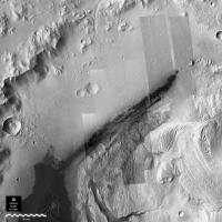
The terrain is quite amazing. I thought I'd grab the HiRise images that Paolo mentioned and put them together on a lower resolution image of a section of Gale Crater. Unfortunately, there was one image I couldn't find to complete the mosaic (if anyone knows where to find it, let me know). These are not the full size versions available from MRO and I've tried to match them up as best I can. This just serves to whet the appetite for what's to come from Curiosity's cameras.
EDIT: IMAGE UPDATE: FOUND THE MISSING BITS!! There's a full size version on my blog - note it's 58.4mb and 15,623 x 15,623 pixels. Note above the 15km scale bar, there's an image of Victoria Crater to emphasis the scale of what we are about to explore. Here's a crop from the full image:
Enjoy!
|
||
|
|
|
||
|
Jul 20 2012, 11:45 AM
Post
#177
|
|
|
Senior Member Group: Members Posts: 1465 Joined: 9-February 04 From: Columbus OH USA Member No.: 13 |
QUOTE (RoverDriver @ Jul 19 2012, 09:32 AM) Ah, for the Jpeg2000 images I use the Kakadu software. I convert it to PGM then work from there. kdu_expand can expand at different resolutions, I believe you can crop as well. Yes the images are BIG. PM me if you need help with kdu_expand. Thanks for that tip--I see that Kakadu is fairly high-priced software but they provide "demo" packages for free with some subset of the capabilities & the Linux demo version at least has the kdu_expand command-line tool. Unfortunately for me they only provide 64-bit executables & my Linux box is 32-bit & so would have to upgrade before I can use it. It would be fun to see a print of just one of the highest-resolution HiRISE strips, for example one of the 1 mpp files is about 7800x22000 pixels, so I assume the 0.25 mpp files would be 4x that, like 31000x88000. My printer is about 600 dpi I think, so that would be about a 4 foot by 12 foot poster! There's a nice free program called PosteRazor for printing out tiles of a large poster for trimming and pasting together, but as in this case it would be over 60 legal size sheets, I have to say it's not going to happen.
-------------------- |
|
|
|
|
Jul 20 2012, 01:00 PM
Post
#178
|
|
 Senior Member Group: Moderator Posts: 2262 Joined: 9-February 04 From: Melbourne - Oz Member No.: 16 |
Re: Handling HiRISE images. When I've worked these in the past (most notably with the Victoria to Endeavour ripple mapping) I used the PDS_JP2 binaries to convert subsections to PDS format then those subsections back to JP2, then ImageMagick or custom code for further conversion/processing.
-------------------- |
|
|
|
|
Jul 20 2012, 02:13 PM
Post
#179
|
|
|
Newbie Group: Members Posts: 11 Joined: 26-April 07 Member No.: 2029 |
Great pics Astro! Does anyone know just how many meters MSL is projected to be able to climb of the 5 km mountain. Matt Golombek was pretty clear that MSL will definetely not be able to climb up the "unknown material" just above the canyon that MSL will be traversing. He said it is way to steep.
|
|
|
|
|
Jul 20 2012, 02:46 PM
Post
#180
|
|
|
Member Group: Admin Posts: 976 Joined: 29-September 06 From: Pasadena, CA - USA Member No.: 1200 |
QUOTE (jmknapp @ Jul 20 2012, 03:45 AM) Thanks for that tip--I see that Kakadu is fairly high-priced software but they provide "demo" packages for free with some subset of the capabilities & the Linux demo version at least has the kdu_expand command-line tool. Unfortunately for me they only provide 64-bit executables & my Linux box is 32-bit & so would have to upgrade before I can use it. It would be fun to see a print of just one of the highest-resolution HiRISE strips, for example one of the 1 mpp files is about 7800x22000 pixels, so I assume the 0.25 mpp files would be 4x that, like 31000x88000. My printer is about 600 dpi I think, so that would be about a 4 foot by 12 foot poster! There's a nice free program called PosteRazor for printing out tiles of a large poster for trimming and pasting together, but as in this case it would be over 60 legal size sheets, I have to say it's not going to happen. Have you tried this If this does not work let me know and I will try to find something else. Or drop them an email, they are quite responsive. Paolo QUOTE (Astro0 @ Jul 20 2012, 02:15 AM) .... Unfortunately, there was one image I couldn't find to complete the mosaic (if anyone knows where to find it, let me know). .... Which one are you missing? Paolo -------------------- Disclaimer: all opinions, ideas and information included here are my own,and should not be intended to represent opinion or policy of my employer.
|
|
|
|
|

|
Lo-Fi Version | Time is now: 27th April 2024 - 08:13 PM |
|
RULES AND GUIDELINES Please read the Forum Rules and Guidelines before posting. IMAGE COPYRIGHT |
OPINIONS AND MODERATION Opinions expressed on UnmannedSpaceflight.com are those of the individual posters and do not necessarily reflect the opinions of UnmannedSpaceflight.com or The Planetary Society. The all-volunteer UnmannedSpaceflight.com moderation team is wholly independent of The Planetary Society. The Planetary Society has no influence over decisions made by the UnmannedSpaceflight.com moderators. |
SUPPORT THE FORUM Unmannedspaceflight.com is funded by the Planetary Society. Please consider supporting our work and many other projects by donating to the Society or becoming a member. |
|