MSL landing site: Gale Crater |

  |
MSL landing site: Gale Crater |
 Jul 20 2012, 04:11 PM Jul 20 2012, 04:11 PM
Post
#181
|
|
|
Solar System Cartographer  Group: Members Posts: 10153 Joined: 5-April 05 From: Canada Member No.: 227 |
"Matt Golombek was pretty clear that MSL will definetely not be able to climb up the "unknown material" just above the canyon that MSL will be traversing. He said it is way to steep."
Too steep there, but we can reasonably expect a long extended mission. It should be possible to work around the lower levels of the mountain to the south and maybe find other ways up. The slopes look gentler as you go further south and east. There's also a much larger and more spectacular canyon to look at. Phil -------------------- ... because the Solar System ain't gonna map itself.
Also to be found posting similar content on https://mastodon.social/@PhilStooke Maps for download (free PD: https://upload.wikimedia.org/wikipedia/comm...Cartography.pdf NOTE: everything created by me which I post on UMSF is considered to be in the public domain (NOT CC, public domain) |
 |
 
|
|
Jul 20 2012, 10:26 PM
Post
#182
|
|
|
Member Group: Members Posts: 706 Joined: 22-April 05 Member No.: 351 |
QUOTE (Phil Stooke @ Jul 20 2012, 08:11 AM)  Too steep there, but we can reasonably expect a long extended mission. It should be possible to work around the lower levels of the mountain to the south and maybe find other ways up. If I remember correctly, the new landing ellipse misses the possible delta on the crater floor. With that long a mission, maybe she could make a detour across the flats. -------------------- |
|
|
|
|
Jul 20 2012, 11:01 PM
Post
#183
|
|
|
Solar System Cartographer Group: Members Posts: 10153 Joined: 5-April 05 From: Canada Member No.: 227 |
A very good point, and I think there are other fans that could be investigated as well.
Phil -------------------- ... because the Solar System ain't gonna map itself.
Also to be found posting similar content on https://mastodon.social/@PhilStooke Maps for download (free PD: https://upload.wikimedia.org/wikipedia/comm...Cartography.pdf NOTE: everything created by me which I post on UMSF is considered to be in the public domain (NOT CC, public domain) |
|
|
|
|
Jul 20 2012, 11:06 PM
Post
#184
|
|
|
Member Group: Admin Posts: 976 Joined: 29-September 06 From: Pasadena, CA - USA Member No.: 1200 |
QUOTE (Phil Stooke @ Jul 20 2012, 04:01 PM) A very good point, and I think there are other fans that could be investigated as well. Phil I don't think they would drive Nort if we land South of the fan but if we want to examine fans I suggest we devote our attention to UMSF fans ;-) Paolo -------------------- Disclaimer: all opinions, ideas and information included here are my own,and should not be intended to represent opinion or policy of my employer.
|
|
|
|
|
Jul 20 2012, 11:12 PM
Post
#185
|
|
|
Member Group: Members Posts: 706 Joined: 22-April 05 Member No.: 351 |
QUOTE (RoverDriver @ Jul 20 2012, 03:06 PM) I don't think they would drive Nort if we land South of the fan This would be years from now after she has gone as far up the canyon has possible. If she has to drive back down to go to another canyon as Phil suggests, perhaps then a diversion to the delta? -------------------- |
|
|
|
|
Jul 20 2012, 11:34 PM
Post
#186
|
||
|
Solar System Cartographer Group: Members Posts: 10153 Joined: 5-April 05 From: Canada Member No.: 227 |
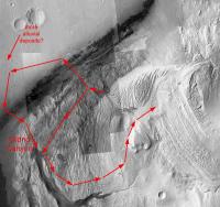
We can play endless games about extended missions, and it's probably premature to do so, but here are possible routes from the primary mission target area, one going back to the plains to explore a different deposit, then to the mouth of the 'Grand Canyon' (as it was called in one MSL workshop presentation), the other skirting the mound to end up at the same place. Then either one could be extended up gentler slopes to the upper mound. Detailed DEM analysis required of course, but feasible routes can probably be found. The real point is, there is tons of potential at this site for great extended missions. (base is Astro0's mosaic)
Phil
-------------------- ... because the Solar System ain't gonna map itself.
Also to be found posting similar content on https://mastodon.social/@PhilStooke Maps for download (free PD: https://upload.wikimedia.org/wikipedia/comm...Cartography.pdf NOTE: everything created by me which I post on UMSF is considered to be in the public domain (NOT CC, public domain) |
|
|
|
|
|
|
Jul 21 2012, 12:58 AM
Post
#187
|
|
|
Member Group: Admin Posts: 976 Joined: 29-September 06 From: Pasadena, CA - USA Member No.: 1200 |
QUOTE (vjkane @ Jul 20 2012, 04:12 PM) This would be years from now after she has gone as far up the canyon has possible. If she has to drive back down to go to another canyon as Phil suggests, perhaps then a diversion to the delta? I understand, but I still believe they would want to go up and then around Mt.Sharp before considering going North. It would be akin to Opportunity driving back north, East of Victoria. But this is just a guess of course, nobody knows for sure. Paolo -------------------- Disclaimer: all opinions, ideas and information included here are my own,and should not be intended to represent opinion or policy of my employer.
|
|
|
|
|
Jul 21 2012, 06:00 AM
Post
#188
|
||
 Senior Member Group: Admin Posts: 3108 Joined: 21-December 05 From: Canberra, Australia Member No.: 615 |
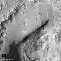
QUOTE Which one are you missing? Paolo The bit I'm missing I've marked below. Any thoughts?
The only image which you referenced that I couldn't find was ESP_024102_175N It wasn't clear which one that might be on the HiRise site. |
|
|
|
|
|
|
Jul 21 2012, 06:22 AM
Post
#189
|
|
|
Member Group: Admin Posts: 976 Joined: 29-September 06 From: Pasadena, CA - USA Member No.: 1200 |
QUOTE (Astro0 @ Jul 20 2012, 11:00 PM) The bit I'm missing I've marked below. Any thoughts? Looking at my mosaic, it seems to be this one. QUOTE ... The only image which you referenced that I couldn't find was ESP_024102_175N It wasn't clear which one that might be on the HiRise site. Sorry, as I was saying in an earlier post, ESP_024102_1755 was split in two by USGS when computing the DTM. You can safely discard ESP_024102_175N, it is a figment of my imagination ;-) Paolo -------------------- Disclaimer: all opinions, ideas and information included here are my own,and should not be intended to represent opinion or policy of my employer.
|
|
|
|
|
Jul 21 2012, 10:45 AM
Post
#190
|
|
|
Senior Member Group: Admin Posts: 3108 Joined: 21-December 05 From: Canberra, Australia Member No.: 615 |
QUOTE (RoverDriver @ Jul 21 2012, 04:22 PM) Looking at my mosaic, it seems to be this one. Unfortunately, it's not that one. It's a strip to the left of that one. Somewhere between ESP_018854_1755 and ESP_023957_1755. I might have missed it in my search on HiRise. I'll keep looking.  EDIT: After a bit of digging I found the images I needed. They don't overlap perfectly but they're really close. I've posted the full version to my blog. It's 58.4mb and still 15,623 x 15,623 pixels. I've also relinked the image in the post I made earlier. |
|
|
|
|
Jul 21 2012, 02:58 PM
Post
#191
|
|
|
Member Group: Admin Posts: 976 Joined: 29-September 06 From: Pasadena, CA - USA Member No.: 1200 |
QUOTE (Astro0 @ Jul 21 2012, 03:45 AM) Unfortunately, it's not that one. It's a strip to the left of that one. Somewhere between ESP_018854_1755 and ESP_023957_1755. That would be PSP_010573_1755 which unfortunetely the search utility does not find. I wrote a script to compute the link to the non-map projected and map projected JP2 images which is a pretty trivial thing to do and use wget to downlink them. If you use the direct link the images are still there. I'm not so sure whether it is OK for me to publish the script, but it is really trivial. Paolo -------------------- Disclaimer: all opinions, ideas and information included here are my own,and should not be intended to represent opinion or policy of my employer.
|
|
|
|
|
Jul 23 2012, 12:35 AM
Post
#192
|
|
 Senior Member Group: Members Posts: 1465 Joined: 9-February 04 From: Columbus OH USA Member No.: 13 |
QUOTE (RoverDriver @ Jul 20 2012, 10:46 AM) Have you tried this Thanks, that works on my Ubuntu 32-bit machine--at least, kdu_expand will convert a full-resolution JP2 file to pgm format, which ImageMagick seems to be able to handle better. The files are still kind of a bear to work with (100,000 pixels high!) but kdu_expand also can reduce the size by 2, 4, etc. & that seems to work well. -------------------- |
|
|
|
|
Jul 23 2012, 04:04 AM
Post
#193
|
|
|
Member Group: Admin Posts: 976 Joined: 29-September 06 From: Pasadena, CA - USA Member No.: 1200 |
QUOTE (jmknapp @ Jul 22 2012, 05:35 PM) Thanks, that works on my Ubuntu 32-bit machine--at least, kdu_expand will convert a full-resolution JP2 file to pgm format, which ImageMagick seems to be able to handle better. The files are still kind of a bear to work with (100,000 pixels high!) but kdu_expand also can reduce the size by 2, 4, etc. & that seems to work well. kdu_expand can also crop the image, so if you have trouble with the full-size you can try splitting it in sections. Can I ask you what are you trying to do? I might be able to help. Paolo -------------------- Disclaimer: all opinions, ideas and information included here are my own,and should not be intended to represent opinion or policy of my employer.
|
|
|
|
|
Jul 23 2012, 09:53 AM
Post
#194
|
|
|
Senior Member Group: Members Posts: 1465 Joined: 9-February 04 From: Columbus OH USA Member No.: 13 |
QUOTE (RoverDriver @ Jul 23 2012, 12:04 AM) kdu_expand can also crop the image, so if you have trouble with the full-size you can try splitting it in sections. Can I ask you what are you trying to do? I might be able to help. Paolo Well, a while back in this thread I was simply asking if someone had already put together a mosaic of full-resolution HiRISE images of the landing site. Emily Lakdawalla posted a link to this mosaic in her blog, courtesy Tanya Harrison: http://planetary.s3.amazonaws.com/misc/Gal...erged_Scale.jpg That's about 7000x7000 pixels with a scale of about 10 meters per pixel. On a 600 dpi printer that would be good for about a 1-foot by 1-foot poster. So full HiRISE resolution (0.25 mpp) would be something like forty times larger, 40 feet by 40 feet! OK, that's insane. Practically, getting resolution sufficient to print out a detailed 4 foot by 4 foot poster (30000x30000 pixels in this case) is what I'm interested in. Anyway, I wasn't really looking to do this myself, but nice to know about some of the tools that would be needed. The cropping feature of kdu_expand that you mention is interesting. Like maybe if one is interested in making a map of a certain region, the HiRISE images could be treated as kind of a database & relevant segments could be extracted from the various images and pieced together automatically. -------------------- |
|
|
|
|
Jul 23 2012, 01:16 PM
Post
#195
|
|
|
Founder Group: Chairman Posts: 14432 Joined: 8-February 04 Member No.: 1 |
Tanya's mosaic is CTX, not HiRISE.
|
|
|
|
|

|
Lo-Fi Version | Time is now: 28th April 2024 - 12:29 AM |
|
RULES AND GUIDELINES Please read the Forum Rules and Guidelines before posting. IMAGE COPYRIGHT |
OPINIONS AND MODERATION Opinions expressed on UnmannedSpaceflight.com are those of the individual posters and do not necessarily reflect the opinions of UnmannedSpaceflight.com or The Planetary Society. The all-volunteer UnmannedSpaceflight.com moderation team is wholly independent of The Planetary Society. The Planetary Society has no influence over decisions made by the UnmannedSpaceflight.com moderators. |
SUPPORT THE FORUM Unmannedspaceflight.com is funded by the Planetary Society. Please consider supporting our work and many other projects by donating to the Society or becoming a member. |
|