Spring at Cape York, Sol 2947 (after Greeley Haven) - sol 3040 |

  |
Spring at Cape York, Sol 2947 (after Greeley Haven) - sol 3040 |
 Jul 24 2012, 10:04 AM Jul 24 2012, 10:04 AM
Post
#391
|
||
 The Poet Dude  Group: Moderator Posts: 5551 Joined: 15-March 04 From: Kendal, Cumbria, UK Member No.: 60 |
Wow... are we already on the other side of Whim Creek?
( More images: http://roadtoendeavour.wordpress.com/2012/...y-to-whim-creek ) -------------------- |
|
 |
 
|
|
|
Jul 24 2012, 10:10 AM
Post
#392
|
|
|
Member Group: Admin Posts: 976 Joined: 29-September 06 From: Pasadena, CA - USA Member No.: 1200 |
QUOTE (Stu @ Jul 24 2012, 02:04 AM)  Wow... are we already on the other side of Whim Creek? Yup! The drive went quite well. Not sure if the geologists will like what they see in the front, but we got a flagstone in the IDD work volume. We got down the full 10x1 and the lower tier NAVCAM already! Paolo -------------------- Disclaimer: all opinions, ideas and information included here are my own,and should not be intended to represent opinion or policy of my employer.
|
|
|
|
|
Jul 24 2012, 04:18 PM
Post
#393
|
|
 Senior Member Group: Moderator Posts: 3431 Joined: 11-August 04 From: USA Member No.: 98 |
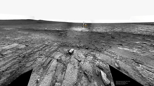 MERB3021WhimCreek2View1 on Flickr 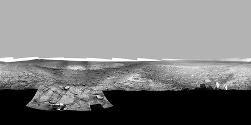 MERB3021WhimCreek2NavcamLeft on Flickr 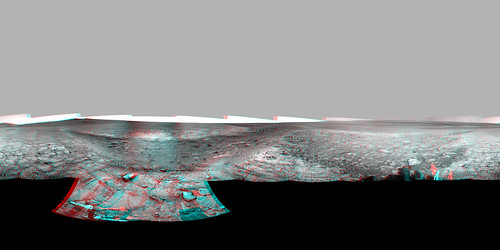 MERB3021WhimCreek2NavcamAnaglyph on Flickr Quicktime VR versions of the full 360 Navcam pan: left eye; anaglyph. As usual my anaglyph panoramas have some ugly seams but perhaps get the point across. I don't know... this site has got to be right up there in the list of incredible MER views, for me anyway. |
|
|
|
|
Jul 24 2012, 04:24 PM
Post
#394
|
||
|
Founder Group: Chairman Posts: 14431 Joined: 8-February 04 Member No.: 1 |
It's a beauty.
Attached thumbnail(s)
|
|
|
|
|
|
|
Jul 24 2012, 04:31 PM
Post
#395
|
||
 Member Group: Members Posts: 404 Joined: 5-January 10 Member No.: 5161 |
I can't believe they drove right across! The other side looks like a steep drop off, Oppy must have been at a steep angle. Lots of nice new images, but have to get to work now

|
|
|
|
|
|
|
Jul 24 2012, 05:08 PM
Post
#396
|
|
|
Member Group: Admin Posts: 976 Joined: 29-September 06 From: Pasadena, CA - USA Member No.: 1200 |
QUOTE (walfy @ Jul 24 2012, 08:31 AM) I can't believe they drove right across! The other side looks like a steep drop off, Oppy must have been at a steep angle. Lots of nice new images, but have to get to work now We hit 23 deg but it was for a really short time and that was expected. It is not a big deal. Driving at 23 deg for a long drive while avoiding big rocks is a different thing but here even if we skidded a bit it would not have had any consequences. Paolo -------------------- Disclaimer: all opinions, ideas and information included here are my own,and should not be intended to represent opinion or policy of my employer.
|
|
|
|
|
Jul 24 2012, 05:29 PM
Post
#397
|
|
 Senior Member Group: Members Posts: 4246 Joined: 17-January 05 Member No.: 152 |
QUOTE (RoverDriver @ Jul 24 2012, 05:08 PM) It is not a big deal. Not for an experienced rover driver like Paolo, anyway! What an exciting final drive - congratulations and thanks for getting us this far!  
|
|
|
|
|
Jul 24 2012, 08:06 PM
Post
#398
|
|
|
Senior Member Group: Members Posts: 2918 Joined: 14-February 06 From: Very close to the Pyrénées Mountains (France) Member No.: 682 |
I join the gang to thank you¨Paolo. And don't tell us you'll try this 23 deg angle on your next drive on the next rover
Should be exciting learning everything all over again on another vehicule. Good luck and see you there. -------------------- |
|
|
|
|
Jul 24 2012, 08:36 PM
Post
#399
|
||
|
Solar System Cartographer Group: Members Posts: 10146 Joined: 5-April 05 From: Canada Member No.: 227 |
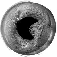
My version of the polar pan:
Phil -------------------- ... because the Solar System ain't gonna map itself.
Also to be found posting similar content on https://mastodon.social/@PhilStooke NOTE: everything created by me which I post on UMSF is considered to be in the public domain (NOT CC, public domain) |
|
|
|
|
|
|
Jul 24 2012, 08:52 PM
Post
#400
|
|
 Junior Member Group: Members Posts: 96 Joined: 11-February 04 Member No.: 24 |
Paolo,
I have to chime in as well and thank you for your excellent work. I've been closely following the "dagger" and very glad that we finally got there. I was hoping for something that was obviously hydraulic but at least we now have a clear image of it. So I guess the consensus is that the "dagger" is a crack and not some aeolian feature? |
|
|
|
|
Jul 24 2012, 09:02 PM
Post
#401
|
|
|
Solar System Cartographer Group: Members Posts: 10146 Joined: 5-April 05 From: Canada Member No.: 227 |
Check out the edge of the bright material under the rover in my polar pan just above... and follow that edge towards the lower right. It looks to me like the bright layer is being eroded back from a previously more etensive coverage of the area. The edge is sharp, and outward from it the rough surface consists of disaggregated fragments of the bright material. I suggest the Dagger is just a place where that disaggregation and erosion has extended along a fracture. There are smaller fractures on each side of it, visible in this and the previous polar pan.
Phil -------------------- ... because the Solar System ain't gonna map itself.
Also to be found posting similar content on https://mastodon.social/@PhilStooke NOTE: everything created by me which I post on UMSF is considered to be in the public domain (NOT CC, public domain) |
|
|
|
|
Jul 24 2012, 10:29 PM
Post
#402
|
|
|
Junior Member Group: Members Posts: 96 Joined: 11-February 04 Member No.: 24 |
QUOTE (Phil Stooke @ Jul 24 2012, 09:02 PM) Check out the edge of the bright material under the rover in my polar pan just above... and follow that edge towards the lower right. It looks to me like the bright layer is being eroded back from a previously more extensive coverage of the area. The edge is sharp, and outward from it the rough surface consists of disaggregated fragments of the bright material. I suggest the Dagger is just a place where that disaggregation and erosion has extended along a fracture. There are smaller fractures on each side of it, visible in this and the previous polar pan. Phil Phil, Referring to your polar pan, I observe to the right of the dagger's tip a feature that looks like the beginning of a new dagger. It's curious that there is only one dagger visible on Cape York. How old is the dagger? A problem I have with Mars is the extreme antiquity of its surface features. My intuition based upon terrestrial geology is largely inappropriate when trying to understand Martian geology. |
|
|
|
|
Jul 24 2012, 10:39 PM
Post
#403
|
|
|
Solar System Cartographer Group: Members Posts: 10146 Joined: 5-April 05 From: Canada Member No.: 227 |
You're right, that could be a baby dagger! But don't forget the one at the very northern tip of Cape York, called Mount Goldsworthy - it's less well developed than Whim Creek but similar and parallel. As for age, I don't know. I assume it takes at least tens of millions of years for these things to form.
Phil -------------------- ... because the Solar System ain't gonna map itself.
Also to be found posting similar content on https://mastodon.social/@PhilStooke NOTE: everything created by me which I post on UMSF is considered to be in the public domain (NOT CC, public domain) |
|
|
|
| Guest_Oersted_* |
Jul 24 2012, 10:41 PM
Post
#404
|
|
Guests |
QUOTE (walfy @ Jul 23 2012, 09:17 PM) Wow!!! Thanks for all the image processing! What a fantastic sight! How I've looked forward to this Martian feature for so long. This shot captures a lot nicely: the creek, foreground crater, slope of Cape York, and distant Endeavour Crater all in one. You forgot: shadow of our intrepid explorer. And: PERFECT composition! This must truly be considered one of the iconic images of Oppy's trek. There's no colour version, is there? I guess they jumped the creek before it was taken... |
|
|
|
|
Jul 25 2012, 12:24 AM
Post
#405
|
||
|
Member Group: Members Posts: 404 Joined: 5-January 10 Member No.: 5161 |
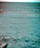
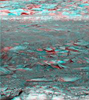
A part of the creek in 3D:
|
|
|
|
|
|
|

|
Lo-Fi Version | Time is now: 19th April 2024 - 11:56 PM |
|
RULES AND GUIDELINES Please read the Forum Rules and Guidelines before posting. IMAGE COPYRIGHT |
OPINIONS AND MODERATION Opinions expressed on UnmannedSpaceflight.com are those of the individual posters and do not necessarily reflect the opinions of UnmannedSpaceflight.com or The Planetary Society. The all-volunteer UnmannedSpaceflight.com moderation team is wholly independent of The Planetary Society. The Planetary Society has no influence over decisions made by the UnmannedSpaceflight.com moderators. |
SUPPORT THE FORUM Unmannedspaceflight.com is funded by the Planetary Society. Please consider supporting our work and many other projects by donating to the Society or becoming a member. |
|