MSL landing site: Gale Crater |

  |
MSL landing site: Gale Crater |
 Jul 27 2012, 01:31 PM Jul 27 2012, 01:31 PM
Post
#241
|
|
|
Member  Group: Admin Posts: 976 Joined: 29-September 06 From: Pasadena, CA - USA Member No.: 1200 |
QUOTE (jmknapp @ Jul 27 2012, 03:46 AM)  I found this: That is the post I was looking for. Thanks Joe. Let me know if that description is sufficient. Paolo -------------------- Disclaimer: all opinions, ideas and information included here are my own,and should not be intended to represent opinion or policy of my employer.
|
 |
 
|
|
Jul 27 2012, 02:47 PM
Post
#242
|
|
 Senior Member Group: Members Posts: 4246 Joined: 17-January 05 Member No.: 152 |
QUOTE (pgrindrod @ Jul 27 2012, 09:39 AM) They're obviously greatly reduced in size here, but should come in handy for playing with over the next few weeks!  Thanks for these, Pete! Any chance you could add elevation and slope scales to those? Higher resolution would be cool too... |
|
|
|
|
Jul 27 2012, 07:19 PM
Post
#243
|
|
 Senior Member Group: Members Posts: 1465 Joined: 9-February 04 From: Columbus OH USA Member No.: 13 |
QUOTE (RoverDriver @ Jul 27 2012, 09:31 AM) That is the post I was looking for. Thanks Joe. Let me know if that description is sufficient. Paolo Very good--info on the IMG format is surprisingly hard to come by. With your slope map, do you encode both slope and aspect, e.g., color to indicate aspect and saturation for slope? Also, you say you just go over some pixels in each of the cardinal directions to get an average slope--is that optimal or for convenience? I.e., why not a square or roughly circular area? As for how far to go, I guess there's a tradeoff between resolution and too much noise & maybe computer time. -------------------- |
|
|
|
|
Jul 27 2012, 08:09 PM
Post
#244
|
|
|
Member Group: Members Posts: 890 Joined: 18-November 08 Member No.: 4489 |
QUOTE Here's a post with links to a tight crop of the landing area (13000x10000 pixels 40 MB) along with the large view of the mosaic (30017×46254 pixels 240 MB): ------------------------------- A heads up for people - the large JPG is a bit too large for most programs, it will freak them out and they'll report it as corrupted. OpenEV was able to do it, but Photoshop, ImageJ, IrfanView - all refused. that is a small image 30k x 46k Nip2 has NO problem showing my 131070 x 65535 RGB 12 Gig Venus map |
|
|
|
|
Jul 27 2012, 08:56 PM
Post
#245
|
|
|
Member Group: Admin Posts: 976 Joined: 29-September 06 From: Pasadena, CA - USA Member No.: 1200 |
QUOTE (jmknapp @ Jul 27 2012, 11:19 AM) Very good--info on the IMG format is surprisingly hard to come by. With your slope map, do you encode both slope and aspect, e.g., color to indicate aspect and saturation for slope? Also, you say you just go over some pixels in each of the cardinal directions to get an average slope--is that optimal or for convenience? I.e., why not a square or roughly circular area? As for how far to go, I guess there's a tradeoff between resolution and too much noise & maybe computer time. What I use is a 3x3 pixel kernel, that way I have the slopes on a rover scale. Suppose I name the DTM "pixels" d11, d12, d13, d21, d22, d23, d31, d32, d33 (in row major order), I compute CODE SlopeEW = ( slope(d12,d11) + slope(d13,d12) + slope(d22,d21) + slope(d23,d22) + slope(d32,d31) + slope(d33,d32) ) / 6; Similarly I compute the slopeNS. This has teh advantage of giving lower noise on the slopes and still have enough detail in the DTM. I do not encode in a single map both magnitude and direction. I have two separate maps where I color code the slope and overlay with some transparency the underlying ortho. Since DTM and ortho are co-registered it is a simple overlay, you don't have to do any manual coregistration. So once you have found your optimal offsets for the ortho mosaic, you can apply the same offsets to the slope overlay. I suggest you compute the slopes one DTM at a time and mosaic teh results otherwise if you try to mosaic the DTM first you will have trouble at the seams between DTMs. There will be some elevation differences that would introduce artifacts. Paolo -------------------- Disclaimer: all opinions, ideas and information included here are my own,and should not be intended to represent opinion or policy of my employer.
|
|
|
|
|
Jul 27 2012, 09:15 PM
Post
#246
|
|
 Senior Member Group: Admin Posts: 4763 Joined: 15-March 05 From: Glendale, AZ Member No.: 197 |
QUOTE (pgrindrod @ Jul 27 2012, 01:39 AM) They're obviously greatly reduced in size here, So Pete, old friend, is there anywhere you can drop them where we might access your full size works? -------------------- If Occam had heard my theory, things would be very different now.
|
|
|
|
|
Jul 28 2012, 02:08 AM
Post
#247
|
|
|
Junior Member Group: Members Posts: 87 Joined: 17-May 08 Member No.: 4114 |
QUOTE (jmknapp @ Jul 27 2012, 03:38 AM) I made a 30000x30000 crop & added it to the blog post--it can be viewed with Photoshop. Thanks for making these. An alternative to monster files would be to use a web based zoomable images. I tried setting up the 40 meg image using panojs (http://www.dimin.net/software/panojs/), and it was very easy. It's free, and all javascript, so it doesn't require anything special on the server or browser. OTOH, you have to split the image into tiles, which is much less convenient for people who want to do more than view the image. If it's OK with you, I'd be happy to host a tiled versions on amazon s3. Of course, I can't sport completely unlimited bandwidth, so if it got too out of hand, I'd have to pull the plug. |
|
|
|
|
Jul 28 2012, 02:32 AM
Post
#248
|
|
|
Senior Member Group: Members Posts: 1465 Joined: 9-February 04 From: Columbus OH USA Member No.: 13 |
QUOTE (Reed @ Jul 27 2012, 10:08 PM) If it's OK with you, I'd be happy to host a tiled versions on amazon s3. Of course, I can't sport completely unlimited bandwidth, so if it got too out of hand, I'd have to pull the plug. Sounds interesting--not familiar with that software. Go for it! -------------------- |
|
|
|
|
Jul 28 2012, 07:47 AM
Post
#249
|
|
|
Junior Member Group: Members Posts: 87 Joined: 17-May 08 Member No.: 4114 |
QUOTE (jmknapp @ Jul 27 2012, 07:32 PM) Go for it! Here's the smaller 13000×10000 crop: removed, see full image link below I'll try to do the full image later. The python script included with panojs3 was not happy with the large image, even after I added 8gb of swap  and imgcnv had dependency issues on the AMI I was using. and imgcnv had dependency issues on the AMI I was using.
|
|
|
|
|
Jul 29 2012, 12:37 AM
Post
#250
|
|
 The Poet Dude Group: Moderator Posts: 5551 Joined: 15-March 04 From: Kendal, Cumbria, UK Member No.: 60 |
If it hasn't hit you yet just how unbelievable and majestic a place Gale Crater is, then go here, and just wander around the crater. This is the best 3D pic I've found of it so far, and honestly, it sent shivers down my spine when I spent some time touring around it...
http://www.geoinf.fu-berlin.de/eng/project...-GaleCrater.jpg (Apologies if it's been posted before, but even if it has it's worth reminding people, especially as there'll be a lot of newcomers here soon. Welcome, by the way!) -------------------- |
|
|
|
|
Jul 29 2012, 12:53 AM
Post
#251
|
|
|
Member Group: Admin Posts: 976 Joined: 29-September 06 From: Pasadena, CA - USA Member No.: 1200 |
QUOTE (jmknapp @ Jul 27 2012, 11:19 AM) Very good--info on the IMG format is surprisingly hard to come by. With your slope map, do you encode both slope and aspect, e.g., color to indicate aspect and saturation for slope? Also, you say you just go over some pixels in each of the cardinal directions to get an average slope--is that optimal or for convenience? I.e., why not a square or roughly circular area? As for how far to go, I guess there's a tradeoff between resolution and too much noise & maybe computer time. I forgot to say that ImageJ can read the DTMs in PDS format, I use the "import" facility, specify the rows and columns, say that it is a 32 bit little endian float, and offset (computed by the difference between the file size and the product of rows*cols*4). You will notice that the "unknown" data points have really large negative numbers. The PDS header includes the valid data range as well. Paolo -------------------- Disclaimer: all opinions, ideas and information included here are my own,and should not be intended to represent opinion or policy of my employer.
|
|
|
|
|
Jul 29 2012, 01:27 AM
Post
#252
|
|
|
Junior Member Group: Members Posts: 87 Joined: 17-May 08 Member No.: 4114 |
I've put up the full size zoomlable image here http://rmmars.s3-website-us-east-1.amazonaws.com/large/
For full effect, I suggest clicking the fullscreen button in the upper right, and the 1:1 on the left. I cropped it very slightly to make an integer number of tiles. Also removed the "small" one, since it's all contained in the large. eta: Added a simple scale bar to the viewer, so you can measure those craters and yardangs 
|
|
|
|
|
Jul 29 2012, 01:55 AM
Post
#253
|
|
|
Member Group: Admin Posts: 976 Joined: 29-September 06 From: Pasadena, CA - USA Member No.: 1200 |
QUOTE (Stu @ Jul 28 2012, 04:37 PM) If it hasn't hit you yet just how unbelievable and majestic a place Gale Crater is, then go here, and just wander around the crater. This is the best 3D pic I've found of it so far, and honestly, it sent shivers down my spine when I spent some time touring around it... http://www.geoinf.fu-berlin.de/eng/project...-GaleCrater.jpg (Apologies if it's been posted before, but even if it has it's worth reminding people, especially as there'll be a lot of newcomers here soon. Welcome, by the way!) Stu, am I lost (again) or in this image North is to the right? Paolo -------------------- Disclaimer: all opinions, ideas and information included here are my own,and should not be intended to represent opinion or policy of my employer.
|
|
|
|
|
Jul 29 2012, 07:44 AM
Post
#254
|
|
|
The Poet Dude Group: Moderator Posts: 5551 Joined: 15-March 04 From: Kendal, Cumbria, UK Member No.: 60 |
Yep, north to the right Paolo. My basic guide for Gale orientation is 'bright stuff at the top = north, dark stuff at the bottom = south'
-------------------- |
|
|
|
|
Jul 29 2012, 08:18 AM
Post
#255
|
||
 Member Group: Members Posts: 404 Joined: 5-January 10 Member No.: 5161 |
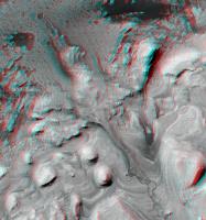
QUOTE (Stu @ Jul 28 2012, 04:37 PM) If it hasn't hit you yet just how unbelievable and majestic a place Gale Crater is, then go here, and just wander around the crater. This is the best 3D pic I've found of it so far, and honestly, it sent shivers down my spine when I spent some time touring around it... http://www.geoinf.fu-berlin.de/eng/project...-GaleCrater.jpg Thanks for that link! What a superb image in 3D! That got me searching for some HiRISE anaglyphs. Maybe you, or others, have "discovered" these already, excuse me if they've been posted already. I did a search for "Gale" at arizona.edu and many ultra-high resolution 3D pictures are listed in there. I'm currently downloading a jpg2000 file of nearly 600MB detailing in 3D that inverted riverbed prime target area in Gale Crater. My bandwidth is slow so I'll have to sleep on it while it downloads. But the pages in the above link provide lower resolution png files of each HiRISE image that are still pretty fantastic. Here's a crop of the inverted riverbed prime target in all its 3D glory:
That terrain looks pretty rough! |
|
|
|
|
|
|

|
Lo-Fi Version | Time is now: 27th April 2024 - 02:23 PM |
|
RULES AND GUIDELINES Please read the Forum Rules and Guidelines before posting. IMAGE COPYRIGHT |
OPINIONS AND MODERATION Opinions expressed on UnmannedSpaceflight.com are those of the individual posters and do not necessarily reflect the opinions of UnmannedSpaceflight.com or The Planetary Society. The all-volunteer UnmannedSpaceflight.com moderation team is wholly independent of The Planetary Society. The Planetary Society has no influence over decisions made by the UnmannedSpaceflight.com moderators. |
SUPPORT THE FORUM Unmannedspaceflight.com is funded by the Planetary Society. Please consider supporting our work and many other projects by donating to the Society or becoming a member. |
|