MSL landing site: Gale Crater |

  |
MSL landing site: Gale Crater |
| Guest_Oersted_* |
 Jul 29 2012, 03:48 PM Jul 29 2012, 03:48 PM
Post
#256
|
|
Guests |
I seem to recall reading somewhere that all the terrain Curiosity could possibly encounter would be sufficiently benign for her to scale it with no great difficulty. What should I believe?
|
 |
 
|
|
Jul 29 2012, 06:41 PM
Post
#257
|
||
 Member  Group: Members Posts: 404 Joined: 5-January 10 Member No.: 5161 |
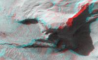
QUOTE (Oersted @ Jul 29 2012, 07:48 AM)  I seem to recall reading somewhere that all the terrain Curiosity could possibly encounter would be sufficiently benign for her to scale it with no great difficulty. What should I believe? That can't be the case. I've downloaded 3 of the gargantuan HiRISE jp2000 anaglyph files and the level of 3D detail is staggering, absolutely mind blowing. There are many obvious cliffs! Maybe around the landing site itself the terrain is relatively safe for driving. I hope to download one of the files that have detail of that terrain later, if I can find one. My 6-year-old Power Mac can barely open these jp2 files in Photoshop, had to wait 20 minutes. And when zooming in at 100% you have to move around the red channel sometimes to make it easy on the eyes, and every move of that channel takes minutes of rendering time! A workaround is to select just a portion of the image you want to explore at 100%, copy it, create a new blank Photoshop file (File > New... the dimensions of the new file should match what you just copied), then paste it in that new smaller file. One more step is to flatten the image before moving the red channel around. The inverted riverbed HiRISE image is 22725 x 66369 pixels! I've barely scratched the surface, so to speak, wish had more time to explore. Here's a quick example of a serious cliff near that inverted riverbed, and even though the elevation is exaggerated (not sure by how much), it's certainly too steep for Curie to drive on!
|
|
|
|
|
|
|
Jul 29 2012, 07:04 PM
Post
#258
|
|
|
Merciless Robot Group: Admin Posts: 8783 Joined: 8-December 05 From: Los Angeles Member No.: 602 |
That's not really the point, though.
Curiosity will be capable of reaching a wide variety of geologically diverse locales within the Gale region which will satisfy the mission objectives...and then some, I'm sure. It's a remarkable machine. It is not a magic omnipotent superbot. -------------------- A few will take this knowledge and use this power of a dream realized as a force for change, an impetus for further discovery to make less ancient dreams real.
|
|
|
|
|
Jul 29 2012, 09:31 PM
Post
#259
|
|
|
Junior Member Group: Members Posts: 89 Joined: 25-January 06 Member No.: 661 |
Hi all,
A few years back I tried getting an engineering change request approved to add a magic omnipotent superbot app to MSL (you know ... a real simple one), but it was declined due to insufficient robotherapy time available in the testbed.  Someday perhaps? (well perhaps not magic nor omnipotent). Actually I am certain we could make the rovers more flexible, quicker and smarter. But not yet. As you already know, this beastie already has enough hobbies to keep its wee brain busy. Like many, I have a lot of suggestions for future improvements. (but alas, all of these machines will be to a large extent narcoleptic.) Also it will be a while before we can land on or near some of those cliffs in Gale. I think we know how but I suspect it will take a lot of work. So far it is easier and safer to land in a flat spot and spend long months driving to the cliff faces. Driving up those surfaces will be hard but I am confident that Paolo's trail maps will guide us safely to some great locations. Those are some amazing views!! (What have we gotten ourselves into Paolo?  ) )Although I am amazed at the renderings, I am really really looking forward to peering around from inside Gale. One more week. -Rob Manning MSL Chief Engineer Opinions and jest expressed are those of the author and do not represent the views of NASA, JPL nor Caltech. |
|
|
|
|
Jul 29 2012, 10:07 PM
Post
#260
|
|
|
Merciless Robot Group: Admin Posts: 8783 Joined: 8-December 05 From: Los Angeles Member No.: 602 |
Rob, if anyone could design an MOS app it would be you.
 Think you guys have one hell of a spacecraft that's almost there...looking forward to next Sunday night, and the weeks & years to follow! Think you guys have one hell of a spacecraft that's almost there...looking forward to next Sunday night, and the weeks & years to follow!
-------------------- A few will take this knowledge and use this power of a dream realized as a force for change, an impetus for further discovery to make less ancient dreams real.
|
|
|
|
|
Jul 30 2012, 01:06 AM
Post
#261
|
|
 Senior Member Group: Members Posts: 1465 Joined: 9-February 04 From: Columbus OH USA Member No.: 13 |
QUOTE (Reed @ Jul 28 2012, 09:27 PM) I've put up the full size zoomlable image here http://rmmars.s3-website-us-east-1.amazonaws.com/large/ What a great way to offer up big images online... You mentioned maybe taking it down if the bandwidth demands are too great. I suppose Amazon web services charges a fee for that? -------------------- |
|
|
|
|
Jul 30 2012, 02:05 AM
Post
#262
|
|
 Administrator Group: Admin Posts: 5172 Joined: 4-August 05 From: Pasadena, CA, USA, Earth Member No.: 454 |
It is really fantastic to see this thread revving up for the arrival!
 I can use The Planetary Society's S3 hosting for any large products deemed likely to be useful over the long term. I probably will not be able to follow this thread closely enough to determine what those products are. So if something comes along that seems (1) finished, or at least not likely to change for a while, and (2) something we'll want to be referring to again several months from now, drop me an email and I'll upload it and place a link to it in our nascent "resources" website section. -------------------- My website - My Patreon - @elakdawalla on Twitter - Please support unmannedspaceflight.com by donating here.
|
|
|
|
|
Jul 30 2012, 03:02 AM
Post
#263
|
|
|
Junior Member Group: Members Posts: 87 Joined: 17-May 08 Member No.: 4114 |
QUOTE (jmknapp @ Jul 29 2012, 06:06 PM) What a great way to offer up big images online It's a lot more friendly than a giant image IMO. I'd be happy to share what I learned making these, should probably go in a different thread though. QUOTE I suppose Amazon web services charges a fee for that? Yes, AWS is pay as you go. It's reasonably priced, but they will happily serve up terabytes and bill you for it. I think the zoomable image won't be a big deal, most people aren't going explore the entire image at 1:1 res (possible exception: members of this forum  ) Just to be clear, that browsable image doesn't need to be on AWS, I put it there because it's an easy way to serve large amounts of static content. Assuming you can bulk upload the ~7000 tile images, you could host it on your wordpress account. ) Just to be clear, that browsable image doesn't need to be on AWS, I put it there because it's an easy way to serve large amounts of static content. Assuming you can bulk upload the ~7000 tile images, you could host it on your wordpress account.Getting back to the image, I was thinking it would be nice to fill in the gaps using the 10m/px ctx image Emily posted earlier. It seems like this could be simple (if there isn't distortion somewhere that makes alignment impossible), but I couldn't find a netpbm command that says "if pixel on image A is 0, use pixel from image B". You can make alpha masks I guess, but they would be big... Another thing I've been thinking about is adding additional information on top of the image. Since the view is all done in javascript, it would be pretty easy to make placemarks and have them link to other stuff. |
|
|
|
|
Jul 30 2012, 05:30 AM
Post
#264
|
|
|
Member Group: Admin Posts: 976 Joined: 29-September 06 From: Pasadena, CA - USA Member No.: 1200 |
QUOTE (MarsEngineer @ Jul 29 2012, 01:31 PM) ... Driving up those surfaces will be hard but I am confident that Paolo's trail maps will guide us safely to some great locations. Those are some amazing views!! (What have we gotten ourselves into Paolo? )... I think it will be an incredible adventure and no matter what obstacles Mars is going to throw at us we will find a way. After all the engineers I met on the MSL team remind me of the origin of the word "engineer". 168 hours. Paolo -------------------- Disclaimer: all opinions, ideas and information included here are my own,and should not be intended to represent opinion or policy of my employer.
|
|
|
|
|
Jul 30 2012, 08:08 AM
Post
#265
|
||
|
Member Group: Members Posts: 404 Joined: 5-January 10 Member No.: 5161 |
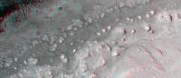
An anaglyph, just right-of-center of landing ellipse (my best estimation). It's a part of this HiRISE image. This crop is about 4.5 km across.
|
|
|
|
|
|
|
Jul 30 2012, 08:16 AM
Post
#266
|
||
|
Member Group: Members Posts: 404 Joined: 5-January 10 Member No.: 5161 |
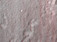
This area is just south of the landing site and just NE of prime target area, also from this HiRISE image set. The image is 4.774 km wide. I think the sand dunes in upper-left side were within the landing ellipse before they shrunk it down in size recently.
|
|
|
|
|
|
|
Jul 30 2012, 11:38 AM
Post
#267
|
|
|
Junior Member Group: Members Posts: 59 Joined: 18-July 07 From: London, UK Member No.: 2873 |
QUOTE (fredk @ Jul 27 2012, 03:47 PM) Thanks for these, Pete! Any chance you could add elevation and slope scales to those? Higher resolution would be cool too... Done and done! I've stuck some slightly larger, and some much larger versions over on my website. They're just higher resolution versions of exported maps, rather than the full-resolution data. I've also made a 2 GB .tiff file of the mosaicked DEMs, which people might be able to use themselves. Perhaps I can take up Emily's kind offer?! In the meantime, if anyone is super keen to get their hands on it then send me a message and I'll see what I can do. Pete |
|
|
|
|
Jul 30 2012, 03:12 PM
Post
#268
|
||||
|
Senior Member Group: Members Posts: 1465 Joined: 9-February 04 From: Columbus OH USA Member No.: 13 |
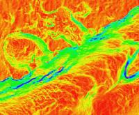
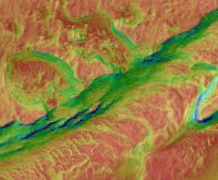
QUOTE (RoverDriver @ Jul 27 2012, 04:56 PM) I do not encode in a single map both magnitude and direction. I have two separate maps where I color code the slope and overlay with some transparency the underlying ortho. Since DTM and ortho are co-registered it is a simple overlay, you don't have to do any manual coregistration. So once you have found your optimal offsets for the ortho mosaic, you can apply the same offsets to the slope overlay. I suggest you compute the slopes one DTM at a time and mosaic teh results otherwise if you try to mosaic the DTM first you will have trouble at the seams between DTMs. There will be some elevation differences that would introduce artifacts. Getting there... I tried one of the Gale DTMs--here's a section at 1 mpp resolution:
Here's that section color-coded for slope as you say (ROYGBIV, from flat to vertical):
And a composite of the two:
-------------------- |
|||
|
|
|
|||
|
Jul 30 2012, 04:33 PM
Post
#269
|
|
 Senior Member Group: Members Posts: 4246 Joined: 17-January 05 Member No.: 152 |
QUOTE (pgrindrod @ Jul 30 2012, 12:38 PM) Done and done! I've stuck some slightly larger, and some much larger versions over on my website. Thanks again, Pete. Just one little thing - the elevation map has the slope scale. |
|
|
|
|
Jul 30 2012, 05:44 PM
Post
#270
|
|
|
Member Group: Admin Posts: 976 Joined: 29-September 06 From: Pasadena, CA - USA Member No.: 1200 |
QUOTE (jmknapp @ Jul 30 2012, 07:12 AM) Getting there... I tried one of the Gale DTMs--here's a section at 1 mpp resolution: ... Joe, I see you are having fun! This is great work. The colormap I use is reversed relative to yours, blue s low slope and red is high slope as this attracts more attention to the bad slopes but it does not really matter. Now, for those of you that have a slope map, try to isolate the areas above 25 degrees. That should be pretty easy. Next try to find areas that are surrounded by slopes higher than 25 degrees. That is a tad more difficult. Now if you join these regions you will have an idea of where MSL is likely not to drive. This does not take into account the different types of terrain of course but it is a start. Paolo -------------------- Disclaimer: all opinions, ideas and information included here are my own,and should not be intended to represent opinion or policy of my employer.
|
|
|
|
|

|
Lo-Fi Version | Time is now: 28th April 2024 - 11:34 AM |
|
RULES AND GUIDELINES Please read the Forum Rules and Guidelines before posting. IMAGE COPYRIGHT |
OPINIONS AND MODERATION Opinions expressed on UnmannedSpaceflight.com are those of the individual posters and do not necessarily reflect the opinions of UnmannedSpaceflight.com or The Planetary Society. The all-volunteer UnmannedSpaceflight.com moderation team is wholly independent of The Planetary Society. The Planetary Society has no influence over decisions made by the UnmannedSpaceflight.com moderators. |
SUPPORT THE FORUM Unmannedspaceflight.com is funded by the Planetary Society. Please consider supporting our work and many other projects by donating to the Society or becoming a member. |
|