MSL landing site: Gale Crater |

  |
MSL landing site: Gale Crater |
 Jul 30 2012, 07:51 PM Jul 30 2012, 07:51 PM
Post
#271
|
|||
 The Insider  Group: Members Posts: 669 Joined: 3-May 04 Member No.: 73 |
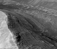
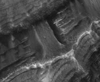
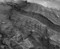
Some perspective images of the cliffs at Gale Crater. This place is unreal.
Attached thumbnail(s)
|
||
 |
 
|
||
|
Jul 30 2012, 07:54 PM
Post
#272
|
||||
|
The Insider Group: Members Posts: 669 Joined: 3-May 04 Member No.: 73 |
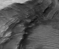
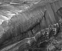
More cliffs...
Attached thumbnail(s)
|
|||
|
|
|
|||
|
Jul 30 2012, 09:31 PM
Post
#273
|
||
 The Poet Dude Group: Moderator Posts: 5551 Joined: 15-March 04 From: Kendal, Cumbria, UK Member No.: 60 |
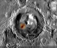
In the red corner... Gale Crater...
In the blue corner... Endeavour Crater... How do they compare? Let's have a look...
Kinda brings it home, doesn't it? 
-------------------- |
|
|
|
|
|
|
Jul 30 2012, 10:46 PM
Post
#274
|
|
 Member Group: Members Posts: 131 Joined: 31-May 08 From: San Carlos, California, USA Member No.: 4168 |
Question for you guys that make the anaglyph images. What are the appropriate glasses to buy? I have a set of glasses from the Pathfinder days, approximately red-blue, but they don't work with the pictures I see here on UMSF.
Glasses will be an absolute necessity for MSL. I hate to ask this question! But I looked in the FAQ and it's not there, and Google didn't help. I found some threads on UMSF with some links to Amazon, but most of the links now go to general Amazon search pages with a dozen different kinds of glasses. http://www.amazon.com/s/?ie=UTF8&keywo...sl_2htsk4yeuh_b http://www.amazon.com/s/ref=nb_sb_noss?url...amp;x=0&y=0 This page has remained direct: http://www.amazon.com/Over-size-Clip-on-An...982&sr=8-12 Thanks. |
|
|
|
|
Jul 30 2012, 10:53 PM
Post
#275
|
|
|
Member Group: Members Posts: 121 Joined: 26-June 04 From: Austria Member No.: 89 |
Is this the deepest Mars landing ever ?
Viking 1 landing in Chryse Planitia was "at reference altitude of −2.69 km relative to a reference ellipsoid with an equatorial radius of 3397.2 km" acc. to Wikipedia. Viking 2 found at about -4.23 km. For Mars Pathfinder I could not find any altitude. Mars3 ? Phoenix was at -4.1km in the northern plains.(Google) MER-A/B I found to be at -1.91/-1.44 km respectively at their ellipse centers. In the "MRO looks down" video I saw for MSL an altitude of -4.912km below the reference ellipsoid - is that correct ? 6 days to go ! Robert |
|
|
|
|
Jul 31 2012, 03:42 AM
Post
#276
|
|
 Member Group: Members Posts: 404 Joined: 5-January 10 Member No.: 5161 |
QUOTE (Syrinx @ Jul 30 2012, 02:46 PM)  Question for you guys that make the anaglyph images. What are the appropriate glasses to buy? I have a set of glasses from the Pathfinder days, approximately red-blue, but they don't work with the pictures I see here on UMSF. Any of those red/blue or red/cyan glasses should work. It's strange that your older pair doesn't work. Make sure the red lens is on the left, blue/cyan on the right. |
|
|
|
|
Jul 31 2012, 04:43 AM
Post
#277
|
||
|
Member Group: Members Posts: 404 Joined: 5-January 10 Member No.: 5161 |
Hovering over part of the Grand Canyon of Gale Crater, 3.42 km across:
|
|
|
|
|
|
|
Jul 31 2012, 07:13 AM
Post
#278
|
||
|
Member Group: Members Posts: 404 Joined: 5-January 10 Member No.: 5161 |
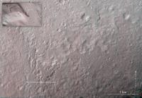
Assuming the rover is 2.9 meters long (according to this webpage) and this HiRISE image resolution is 25 cm per pixel (according to the HiRISE page), then the rover should be 11.6 pixels in length! So I Photoshopped it in to this very small part of a much larger HiRISE image. The image is a crop from the original, no reduction nor increase in size were made. Every pixel is the original, representing 25 cm across the surface of Mars. It's in the "inverted river" prime target area. My best understanding now is that with the good fortune of an extended mission in years to come, we might be driving up here!
|
|
|
|
|
|
|
Jul 31 2012, 09:25 AM
Post
#279
|
|
|
Junior Member Group: Members Posts: 59 Joined: 18-July 07 From: London, UK Member No.: 2873 |
QUOTE (fredk @ Jul 30 2012, 05:33 PM) Thanks again, Pete. Just one little thing - the elevation map has the slope scale. Doh! Thanks fredk, changed accordingly. |
|
|
|
|
Jul 31 2012, 11:57 AM
Post
#280
|
|
|
Member Group: Members Posts: 813 Joined: 29-December 05 From: NE Oh, USA Member No.: 627 |
Gobsmacked!!!!! I just cannot think of another word right now. Gale is magnificent. So is this forum. All you folks who participate on this forum, from the poets, the image mages, the rover drivers, the enginners, the scientists. Magnificent talents all. Thanks for what you do! Craig |
|
|
|
|
Jul 31 2012, 12:00 PM
Post
#281
|
|
 Senior Member Group: Members Posts: 1465 Joined: 9-February 04 From: Columbus OH USA Member No.: 13 |
QUOTE (RoverDriver @ Jul 30 2012, 12:44 PM) Now, for those of you that have a slope map, try to isolate the areas above 25 degrees. That should be pretty easy. Next try to find areas that are surrounded by slopes higher than 25 degrees. That is a tad more difficult. Now if you join these regions you will have an idea of where MSL is likely not to drive. This does not take into account the different types of terrain of course but it is a start. Interesting... I read somewhere that the rover was tested on some crazy steep slopes but that left the question as to what the practical limit is for normal drives. So 25° then. So after masking out the >25° slopes themselves and then the regions that may be flattish but surrounded by >25° moats, I guess that would leave the trail map that MarsEngineer alluded to. Hat's off to you, with the daily responsibility of not putting a multi-billion dollar ride into a ditch or into quicksand & still making the whole enterprise pay off scientifically. -------------------- |
|
|
|
|
Jul 31 2012, 04:19 PM
Post
#282
|
|
|
Member Group: Members Posts: 279 Joined: 19-August 07 Member No.: 3299 |
After seeing the terrain pictures, I realized that this place will be by far the most interesting place to visit Mars! Lots of geology variety (different slopes, different kind of land, close to a high mountain, through a canon) and finally, I am not comfortable to landing place since it is not so plain surface as the MER's landing sites. I still cannot figure out about how the geology has shaped the landing place so bumpy. The time is already approaching fast! Thanks to all who has put nice pictures to let others to see.
|
|
|
|
|
Jul 31 2012, 04:20 PM
Post
#283
|
|
|
Member Group: Admin Posts: 976 Joined: 29-September 06 From: Pasadena, CA - USA Member No.: 1200 |
QUOTE (jmknapp @ Jul 31 2012, 04:00 AM) Interesting... I read somewhere that the rover was tested on some crazy steep slopes but that left the question as to what the practical limit is for normal drives. So 25° then. So after masking out the >25° slopes themselves and then the regions that may be flattish but surrounded by >25° moats, I guess that would leave the trail map that MarsEngineer alluded to. Hat's off to you, with the daily responsibility of not putting a multi-billion dollar ride into a ditch or into quicksand & still making the whole enterprise pay off scientifically. I personally drove Scarecrow on very steep terrain and there are definitely some differences on how it behaves relative to MER. I'm not sure whether the terrain Scarecrow was tested in was all relevant o Gale but it is a start. I'm not sure how much of MER driving will also help. My hunch (not shared by everyone on the driver's team) is that it will be a combination of Gusev and Duck Bay. I will devour the first HAZCAMs and NAVCAMs as you all probably will. My first shift will be on Aug 8! For people that want to explore Gale, I asked ElkGroveDan to post a tarball with a clickable map that links to the appropriate HiRISE pages. Paolo -------------------- Disclaimer: all opinions, ideas and information included here are my own,and should not be intended to represent opinion or policy of my employer.
|
|
|
|
|
Aug 1 2012, 12:39 AM
Post
#284
|
||
|
Member Group: Members Posts: 404 Joined: 5-January 10 Member No.: 5161 |
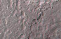
...don't tell my boss why I'm falling behind my work! Here is an anaglyph of my estimation of where the center of the landing ellipse is (based on what I could glean from the interwebs). If anyone with special knowledge could confirm a better estimate of the location, I'd be happy to rework this image.
|
|
|
|
|
|
|
Aug 1 2012, 12:42 AM
Post
#285
|
||
|
Member Group: Members Posts: 404 Joined: 5-January 10 Member No.: 5161 |
Here's my approximate center of the landing ellipse in more detail (see my previous post for wider perspective).
|
|
|
|
|
|
|

|
Lo-Fi Version | Time is now: 28th April 2024 - 03:01 AM |
|
RULES AND GUIDELINES Please read the Forum Rules and Guidelines before posting. IMAGE COPYRIGHT |
OPINIONS AND MODERATION Opinions expressed on UnmannedSpaceflight.com are those of the individual posters and do not necessarily reflect the opinions of UnmannedSpaceflight.com or The Planetary Society. The all-volunteer UnmannedSpaceflight.com moderation team is wholly independent of The Planetary Society. The Planetary Society has no influence over decisions made by the UnmannedSpaceflight.com moderators. |
SUPPORT THE FORUM Unmannedspaceflight.com is funded by the Planetary Society. Please consider supporting our work and many other projects by donating to the Society or becoming a member. |
|