MSL landing site: Gale Crater |

  |
MSL landing site: Gale Crater |
 Aug 1 2012, 12:49 AM Aug 1 2012, 12:49 AM
Post
#286
|
|
|
Member  Group: Admin Posts: 976 Joined: 29-September 06 From: Pasadena, CA - USA Member No.: 1200 |
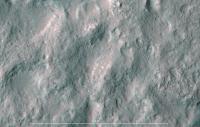
QUOTE (walfy @ Jul 31 2012, 04:42 PM)  Here's my approximate center of the landing ellipse in more detail (see my previous post for wider perspective). ... The location of the center is not critical, of course, but as you can see the ellipse is scattered with mesas. Not very tall mesas like on Mt.Sharp but tall enough to be a hazard. Hopefully we will not have to climb down one of them and meander around all of them! Paolo -------------------- Disclaimer: all opinions, ideas and information included here are my own,and should not be intended to represent opinion or policy of my employer.
|
 |
 
|
|
Aug 1 2012, 12:51 AM
Post
#287
|
||
 Member Group: Members Posts: 404 Joined: 5-January 10 Member No.: 5161 |
Here's the final of this series, with the rover Photoshopped in. It's the closest you can get with the HiRISE images. Again, if someone in the know has a more pinpointed location of the center of the landing ellipse, I'd be happy to rework these images (after I catch up on work! but this is too much fun). this location is just my estimate based on eyeballing several images I could find online. One in particular looked official, and had an x marking the spot. But who knows how accurate it was.
|
|
|
|
|
|
|
Aug 1 2012, 12:52 AM
Post
#288
|
|
|
Member Group: Members Posts: 404 Joined: 5-January 10 Member No.: 5161 |
QUOTE (RoverDriver @ Jul 31 2012, 04:49 PM) The location of the center is not critical, of course, but as you can see the ellipse is scattered with mesas. Not very tall mesas like on Mt.Sharp but tall enough to be a hazard. Hopefully we will not have to climb down one of them and meander around all of them! Paolo Yeah, you're right, not so important. But I hope I'm somewhat close! |
|
|
|
|
Aug 1 2012, 01:04 AM
Post
#289
|
|
 Senior Member Group: Members Posts: 1465 Joined: 9-February 04 From: Columbus OH USA Member No.: 13 |
QUOTE (RoverDriver @ Jul 30 2012, 12:44 PM) Now, for those of you that have a slope map, try to isolate the areas above 25 degrees. That should be pretty easy. Next try to find areas that are surrounded by slopes higher than 25 degrees. That is a tad more difficult. Now if you join these regions you will have an idea of where MSL is likely not to drive. One thing occurs to me--if you have a map with all slopes >25° marked in one color and all those <25° another color, wouldn't a simple flood fill starting from the landing spot paint all the places where the rover could possibly drive and not exceed 25°? -------------------- |
|
|
|
|
Aug 1 2012, 01:05 AM
Post
#290
|
|
|
Senior Member Group: Members Posts: 1465 Joined: 9-February 04 From: Columbus OH USA Member No.: 13 |
QUOTE ellipse is scattered with mesas Is it possible that MSL could land somewhere in the ellipse and be surrounded by steep slopes? -------------------- |
|
|
|
|
Aug 1 2012, 01:19 AM
Post
#291
|
|
|
Founder Group: Chairman Posts: 14432 Joined: 8-February 04 Member No.: 1 |
Those are called rover-traps and they were taken into account during the landing site selection process thru Paolo's amazing work
 There are some, but not many - they represent a tiny tiny fraction of the ellipse. |
|
|
|
|
Aug 1 2012, 01:19 AM
Post
#292
|
|
 Senior Member Group: Members Posts: 1421 Joined: 26-July 08 Member No.: 4270 |
The terrain around the ellipse didn't look that forbidding.
Besides, it can just laser-drill it's way out, right? -------------------- -- Hungry4info (Sirius_Alpha)
|
|
|
|
|
Aug 1 2012, 02:06 AM
Post
#293
|
|
|
Member Group: Admin Posts: 976 Joined: 29-September 06 From: Pasadena, CA - USA Member No.: 1200 |
QUOTE (jmknapp @ Jul 31 2012, 05:04 PM) One thing occurs to me--if you have a map with all slopes >25° marked in one color and all those <25° another color, wouldn't a simple flood fill starting from the landing spot paint all the places where the rover could possibly drive and not exceed 25°? Not exactly. 25 deg is what we believe is the maximum traversable slope on any terrain, but we also believe that the rover will not be able to traverse slopes of more than 12.5 deg on sand. So the area that is > 25 deg is for sure non traversable but the rest might or might not be traversable, it depends on teh terrain configuration and what types of maneuvers you need/want to do. In order to have a better understanding of where teh rover can and cannot drive in my traversability analysis I did include some rudimentary evaluation of the terrain classifying the texture in the HiRISE images. We'll see how this is true to the terrain at Gale. Paolo -------------------- Disclaimer: all opinions, ideas and information included here are my own,and should not be intended to represent opinion or policy of my employer.
|
|
|
|
|
Aug 1 2012, 02:08 AM
Post
#294
|
|
|
Member Group: Admin Posts: 976 Joined: 29-September 06 From: Pasadena, CA - USA Member No.: 1200 |
QUOTE (jmknapp @ Jul 31 2012, 05:05 PM) Is it possible that MSL could land somewhere in the ellipse and be surrounded by steep slopes? Yep, there are some rover traps which were known at the time of selecting the landing site. I got to the point where I can automatically locate mesas, bowls (craters) and ledges. It was fun. Paolo -------------------- Disclaimer: all opinions, ideas and information included here are my own,and should not be intended to represent opinion or policy of my employer.
|
|
|
|
|
Aug 1 2012, 04:59 AM
Post
#295
|
||
 Senior Member Group: Admin Posts: 4763 Joined: 15-March 05 From: Glendale, AZ Member No.: 197 |
QUOTE (RoverDriver @ Jul 31 2012, 07:08 PM) Yep, there are some rover traps which were known at the time of selecting the landing site. Like this?
Attached thumbnail(s)
-------------------- If Occam had heard my theory, things would be very different now.
|
|
|
|
|
|
|
Aug 1 2012, 05:49 AM
Post
#296
|
|
|
Member Group: Admin Posts: 976 Joined: 29-September 06 From: Pasadena, CA - USA Member No.: 1200 |
QUOTE (ElkGroveDan @ Jul 31 2012, 08:59 PM) Like this?  Yes, that's what I call a mesa rover-trap. This type of rover trap would be really devastating. We would be literally sitting on top of layered bedrock but we would not be able to get to it (the arm, much like the IDD, has limited reach below ground level). Paolo -------------------- Disclaimer: all opinions, ideas and information included here are my own,and should not be intended to represent opinion or policy of my employer.
|
|
|
|
|
Aug 1 2012, 11:38 AM
Post
#297
|
|
 Member Group: Members Posts: 754 Joined: 9-February 07 Member No.: 1700 |
I wondered how far up Aeolis Mons MSL would possibly ascend, so I Googled it and found this 2011 article as a reference to the wiki article on MSL.
QUOTE NASA's next Mars rover is a rolling chemistry and geology laboratory, but it may prove to be an expert mountain climber as well.
The car-size Curiosity rover is due to launch Saturday (Nov. 26) on a mission to assess whether the Red Planet is, or ever was, capable of supporting microbial life. In the course of its duties, Curiosity could end up at the summit of a 3-mile-high (5-kilometer) mountain near its landing site, provided it keeps chugging for long enough, researchers said. "We think the slopes are gentle enough that if you took an appropriately circuitous route, you could make it to the top of the mound," John Grotzinger of Caltech, project scientist for Curiosity's $2.5 billion Mars Science Laboratory (MSL) mission, told reporters yesterday (Nov. 22). "But that's way into the future." |
|
|
|
|
Aug 1 2012, 01:23 PM
Post
#298
|
|||
|
Senior Member Group: Members Posts: 1465 Joined: 9-February 04 From: Columbus OH USA Member No.: 13 |
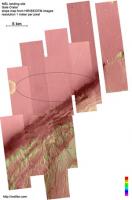
QUOTE (djellison @ Jul 31 2012, 08:19 PM) Those are called rover-traps and they were taken into account during the landing site selection process thru Paolo's amazing work There are some, but not many - they represent a tiny tiny fraction of the ellipse. Finished my slope map. I suppose some of these spots would be among the traps: 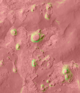 Here's a thumbnail of the slope map: 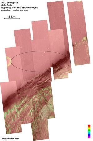 Color-coding is as follows:
The full-res file (31000x47000 at 1 mpp) can be downloaded from my blog: http://mslfan.com/2012/08/01/terrain-at-th...l-landing-site/
Attached thumbnail(s)
-------------------- |
||
|
|
|
||
|
Aug 1 2012, 01:58 PM
Post
#299
|
|
 Senior Member Group: Members Posts: 4246 Joined: 17-January 05 Member No.: 152 |
This is fantastic, Joe. Any chance you could provide an intermediate resolution version, say 2 to 4 mpp, for those who don't want to commit to the full 213 MB?
|
|
|
|
|
Aug 1 2012, 03:09 PM
Post
#300
|
|
|
Senior Member Group: Members Posts: 1465 Joined: 9-February 04 From: Columbus OH USA Member No.: 13 |
QUOTE (fredk @ Aug 1 2012, 08:58 AM) This is fantastic, Joe. Any chance you could provide an intermediate resolution version, say 2 to 4 mpp, for those who don't want to commit to the full 213 MB? OK--just shrunk the image to 4 mpp (17 MB) & added a link at the end of the blog post. Not sure if that's entirely kosher, depending on how ImageMagick averages pixels, but it's probably pretty close. I guess the right way to do it would be to downsample the original DTMs by averaging and recreate the mosaic from scratch--right, but painful! -------------------- |
|
|
|
|

|
Lo-Fi Version | Time is now: 28th April 2024 - 12:58 AM |
|
RULES AND GUIDELINES Please read the Forum Rules and Guidelines before posting. IMAGE COPYRIGHT |
OPINIONS AND MODERATION Opinions expressed on UnmannedSpaceflight.com are those of the individual posters and do not necessarily reflect the opinions of UnmannedSpaceflight.com or The Planetary Society. The all-volunteer UnmannedSpaceflight.com moderation team is wholly independent of The Planetary Society. The Planetary Society has no influence over decisions made by the UnmannedSpaceflight.com moderators. |
SUPPORT THE FORUM Unmannedspaceflight.com is funded by the Planetary Society. Please consider supporting our work and many other projects by donating to the Society or becoming a member. |
|