MSL landing site: Gale Crater |

  |
MSL landing site: Gale Crater |
 Aug 3 2012, 03:42 PM Aug 3 2012, 03:42 PM
Post
#316
|
|
|
Junior Member  Group: Members Posts: 57 Joined: 20-January 12 From: Florida Member No.: 6317 |
I recently heard that part of the mission is to actually climb the central mountain of Gale crater. Why is that? Wouldn't the most evidence for the actions of water be found at the bottom?
|
 |
 
|
|
Aug 3 2012, 03:45 PM
Post
#317
|
|
 Administrator Group: Admin Posts: 5172 Joined: 4-August 05 From: Pasadena, CA, USA, Earth Member No.: 454 |
They're not looking for actions of water in this particular crater; they're looking for evidence of past water as recorded in the rock record. For that, they'll be studying Martian history as they drive up through the layered sediments from which the mountain is built, oldest at the bottom, youngest at the top.
-------------------- My website - My Patreon - @elakdawalla on Twitter - Please support unmannedspaceflight.com by donating here.
|
|
|
|
|
Aug 3 2012, 03:46 PM
Post
#318
|
|
|
Forum Contributor Group: Members Posts: 1372 Joined: 8-February 04 From: North East Florida, USA. Member No.: 11 |
QUOTE (Blue Sky @ Aug 3 2012, 03:42 PM)  I recently heard that part of the mission is to actually climb the central mountain of Gale crater. Why is that? Wouldn't the most evidence for the actions of water be found at the bottom? As you climb the mountain the layers show the younger and younger history of the changes, that way they can figure out a more complete history of the crater. They do indeed expect to find the answers to the main questions at the bottom, the climb to the top will take many more years than the initial two year mission. |
|
|
|
|
Aug 3 2012, 03:51 PM
Post
#319
|
|
|
Member Group: Admin Posts: 976 Joined: 29-September 06 From: Pasadena, CA - USA Member No.: 1200 |
QUOTE (Tesheiner @ Aug 3 2012, 07:49 AM) I'm wondering how would it look on Google Earth. Some time ago I worked with MapTiler to create some background map tiles for Endeavour Crater (Opportunity site) and I think it may be able to handle this picture. Probably, the only real problem will be to correctly register the image (i.e. find the right lat / long coordinates for the corners). Stay tuned. I did get the orthos and my maps on GM but the major issue is that GM DTM is MOLA, so very coarse. I investigated to see if it is possible to override the elevation map but was told that it can't be done in the current implementation of GM. You need to install USGS ISIS, then using the command image2qtree you can generate an image tree that can be imported in GM. You are right that the trick is to find the lat/long. The HiRISE images and DTMs have .LBL files that do include the lat/long of the four corners but they are not very accurate. As a result if you generate a kml file for each strip you will have inaccurate mosaics. What I suggest is to do a mosaic as jmknapp did, determine the four corners for the mosaic and generate the kml file for the entire mosaic. For example for one of the HiRISE orthos I use: CODE StereoPipeline-1.0.4-i386-OSX/bin/image2qtree --north -4.6761972 --south -4.9231142 --west 137.3533450 --east 137.4685592 --nodata 0 PSP_009294_1750_ortho.pgm -m kml -o PSP_009294_1750_out This would take PSP_009294_1750.pgm and generate a directory PSP_009294_1750_out with all the tiles and kml file. Once you have that, you launch GM, switch to Mars, and upload the kml file (File->open, go to PSP_009294_1750_out/PSP_009294_out.kml) Hope this helps. Paolo -------------------- Disclaimer: all opinions, ideas and information included here are my own,and should not be intended to represent opinion or policy of my employer.
|
|
|
|
|
Aug 3 2012, 06:12 PM
Post
#320
|
|
|
Senior Member Group: Moderator Posts: 4279 Joined: 19-April 05 From: .br at .es Member No.: 253 |
QUOTE (RoverDriver @ Aug 3 2012, 05:51 PM) The HiRISE images and DTMs have .LBL files that do include the lat/long of the four corners but they are not very accurate. As a result if you generate a kml file for each strip you will have inaccurate mosaics. Yup, I saw that while working on the opportunity map background. QUOTE What I suggest is to do a mosaic as jmknapp did, determine the four corners for the mosaic and generate the kml file for the entire mosaic. That was the idea and right now I was attempting to use jmknapp's mosaic as starting point but it looks too heavy to my computer. 
|
|
|
|
|
Aug 3 2012, 06:45 PM
Post
#321
|
|
|
Member Group: Admin Posts: 976 Joined: 29-September 06 From: Pasadena, CA - USA Member No.: 1200 |
QUOTE (Tesheiner @ Aug 3 2012, 11:12 AM) Yup, I saw that while working on the opportunity map background. That was the idea and right now I was attempting to use jmknapp's mosaic as starting point but it looks too heavy to my computer. You have the obvious two options: subsample or crop. Well, you have a third one: get a beefier computer ;-) Paolo -------------------- Disclaimer: all opinions, ideas and information included here are my own,and should not be intended to represent opinion or policy of my employer.
|
|
|
|
|
Aug 3 2012, 06:57 PM
Post
#322
|
|
 Senior Member Group: Members Posts: 1465 Joined: 9-February 04 From: Columbus OH USA Member No.: 13 |
QUOTE (Tesheiner @ Aug 3 2012, 02:12 PM) That was the idea and right now I was attempting to use jmknapp's mosaic as starting point but it looks too heavy to my computer. I used a 64-bit Ubuntu system with i7 processor and 8GB RAM to process the DTMs and a similar Windows 7 system with Photoshop for doing the mosaic. At that, working with these images is a bear--many programs will just roll over and die at random, and everything runs slowly. I was amazed when someone upthread said that this was a "small image" and that they load gigabytes or whatever of Venus image at a clip. Have to wonder what kind of $$ that would entail in infrastructure. If it could help, I could tile the image for you & send a link to the individual tiles, if you know the dimensions of the tiles you will need. I'm not familiar with how Google Earth (or Mars) works but would love to see that kind of visualization applied to the HiRISE/DTM data. -------------------- |
|
|
|
|
Aug 3 2012, 10:38 PM
Post
#323
|
||||
|
Senior Member Group: Moderator Posts: 4279 Joined: 19-April 05 From: .br at .es Member No.: 253 |
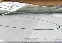
Ok, here's a first and crude attempt on this thing.
"Crude" because I couldn't edit the mosaic to isolate just the picture and apply transparency to the rest of it. It was simply too big. Anyway, here are a few snapshots.
QUOTE (jmknapp @ Aug 3 2012, 08:57 PM) If it could help, I could tile the image for you & send a link to the individual tiles, if you know the dimensions of the tiles you will need. I used 8192x8192 tiles the last time I worked on this subject. This will probably be my next attempt, tomorrow. I think my machine will be capable to tile the picture, otherwise I will contact you Joe. Thanks! QUOTE I'm not familiar with how Google Earth (or Mars) works but would love to see that kind of visualization applied to the HiRISE/DTM data. Frankly, MapTiler (http://www.maptiler.org/) is a very simple tool. You only need a source image and know its boundaries in lat / long and the tool creates a directory tree with the picture as small tiles in several LODs and a KML file to see the picture in GE. Similar to image2qtree which Paolo explained a few posts above. Do you wanna have a try? If yes, I can give you the exact parameters I used with your mosaic. |
|||
|
|
|
|||
|
Aug 3 2012, 10:47 PM
Post
#324
|
|
|
Member Group: Admin Posts: 976 Joined: 29-September 06 From: Pasadena, CA - USA Member No.: 1200 |
If you have the netpbm toolset you can use pnmtile. Joe, the way that these monster images are dealt with is tiling. There are file formats, including TIFF, that support tiling and multiresolution natively. It is not really the computer that is the issue, it is the file format. If you take your maps for example and convert them back to JP2 and use kdu_show, for example, you should be able to move around your bib maps very well.
Paolo -------------------- Disclaimer: all opinions, ideas and information included here are my own,and should not be intended to represent opinion or policy of my employer.
|
|
|
|
|
Aug 3 2012, 10:50 PM
Post
#325
|
|
|
Member Group: Admin Posts: 976 Joined: 29-September 06 From: Pasadena, CA - USA Member No.: 1200 |
QUOTE (Tesheiner @ Aug 3 2012, 03:38 PM) ... Frankly, MapTiler (http://www.maptiler.org/) is a very simple tool. You only need a source image and know its boundaries in lat / long and the tool creates a directory tree with the picture as small tiles in several LODs and a KML file to see the picture in GE. Similar to image2qtree which Paolo explained a few posts above. Do you wanna have a try? If yes, I can give you the exact parameters I used with your mosaic. Good to know. I did not particularly liked the idea of having to install ISIS to do the tiling. It is like having to buy Home Deport to use a hammer.  Paolo -------------------- Disclaimer: all opinions, ideas and information included here are my own,and should not be intended to represent opinion or policy of my employer.
|
|
|
|
|
Aug 4 2012, 08:58 AM
Post
#326
|
|
|
Senior Member Group: Moderator Posts: 4279 Joined: 19-April 05 From: .br at .es Member No.: 253 |
QUOTE (RoverDriver @ Aug 4 2012, 12:47 AM) If you have the netpbm toolset you can use pnmtile. Joe, the way that these monster images are dealt with is tiling. There are file formats, including TIFF, that support tiling and multiresolution natively. It is not really the computer that is the issue, it is the file format. If you take your maps for example and convert them back to JP2 and use kdu_show, for example, you should be able to move around your bib maps very well. Paolo Very true. Those big HiRISE JP2 are more lightweight to handle on OpenEV/FWTools than a 30k x 30k JPEG. |
|
|
|
|
Aug 4 2012, 03:41 PM
Post
#327
|
|||||
|
Senior Member Group: Moderator Posts: 4279 Joined: 19-April 05 From: .br at .es Member No.: 253 |
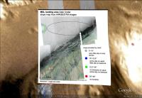
Phew! Here's the second attempt.
First of all I split the mosaic in a 3x3 tileset because the original picture was too big for the second step in my PC which was to apply a transparent background instead of the original white color. Then all nine images were processed with MapTiler and here are a few snapshots of the result.
The whole thing is accessible from a single KML file but is split in a directory tree taking 210MB. Now, let's see how can I share it. |
||||
|
|
|
||||
|
Aug 4 2012, 05:35 PM
Post
#328
|
|
|
Senior Member Group: Members Posts: 1465 Joined: 9-February 04 From: Columbus OH USA Member No.: 13 |
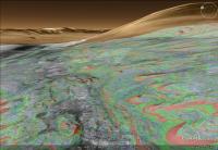
QUOTE (Tesheiner @ Aug 4 2012, 10:41 AM) Phew! Here's the second attempt. Wow, I have to get that. With Google Earth you can overlay tracks, pushpins and the like, right? It'd be fascinating to see the planned path up the mound. The image underscores that the HiRISE/DTM coverage doesn't go very far up Mt. Sharp. I wonder how soon the HiRISE people plan on doing more DTMs covering all the way to the peak? -------------------- |
|
|
|
|
Aug 4 2012, 05:38 PM
Post
#329
|
|
|
Senior Member Group: Moderator Posts: 4279 Joined: 19-April 05 From: .br at .es Member No.: 253 |
I have temporarily hosted the map at Dropbox. Here's the KML file to access it.
Attached File(s)
|
|
|
|
|
Aug 4 2012, 05:50 PM
Post
#330
|
|
|
Senior Member Group: Members Posts: 1465 Joined: 9-February 04 From: Columbus OH USA Member No.: 13 |
QUOTE (Tesheiner @ Aug 4 2012, 12:38 PM) I have temporarily hosted the map at Dropbox. Here's the KML file to access it. Works very slick--GE started up, switched to Mars, homed in on the image, no muss, no fuss. Really fascinating looking at the perspective views, to see the undulating slopes. -------------------- |
|
|
|
|

|
Lo-Fi Version | Time is now: 19th April 2024 - 11:11 PM |
|
RULES AND GUIDELINES Please read the Forum Rules and Guidelines before posting. IMAGE COPYRIGHT |
OPINIONS AND MODERATION Opinions expressed on UnmannedSpaceflight.com are those of the individual posters and do not necessarily reflect the opinions of UnmannedSpaceflight.com or The Planetary Society. The all-volunteer UnmannedSpaceflight.com moderation team is wholly independent of The Planetary Society. The Planetary Society has no influence over decisions made by the UnmannedSpaceflight.com moderators. |
SUPPORT THE FORUM Unmannedspaceflight.com is funded by the Planetary Society. Please consider supporting our work and many other projects by donating to the Society or becoming a member. |
|