MSL at Rocknest, First scoop samples - sols 57-101 |

  |
MSL at Rocknest, First scoop samples - sols 57-101 |
 Oct 18 2012, 09:37 PM Oct 18 2012, 09:37 PM
Post
#256
|
|
|
Senior Member  Group: Members Posts: 1043 Joined: 17-February 09 Member No.: 4605 |
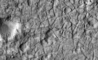
To an extent we have been conditioned by Phoenix to equate polygon formation with ice. In the GSA paper excerpt they are identified as contraction features. These can be caused by dessication, thermal contraction or even chemical reactions and mineral phase changes (or combinations of the above) can have the same effect. I guess the point I am trying to make is that there are a lot of pieces of the jigsaw that have to be put together before we can even make a reasoned guess at what occurred in Gale.
|
 |
 
|
|
Oct 19 2012, 08:32 AM
Post
#257
|
|
 Member Group: Members Posts: 547 Joined: 1-May 06 From: Scotland (Ecosse, Escocia) Member No.: 759 |
Heading to Glenelg, Earth, tomorrow to mark Curiosity's arrival at Glenelg, Mars. Doug McCuistion, Director of the Mars Exploration Program, shuttle astronaut Bonnie Dunbar and John C Brown the Astronomer Royal for Scotland will be there.
Glenelg Event on Facebook |
|
|
|
|
Oct 19 2012, 08:52 AM
Post
#258
|
|
|
Member Group: Members Posts: 282 Joined: 18-June 04 Member No.: 84 |
Shouldn't they really be heading to Glenelg in Canada?
|
|
|
|
|
Oct 19 2012, 08:56 AM
Post
#259
|
|
|
Member Group: Members Posts: 282 Joined: 18-June 04 Member No.: 84 |
This image from sol 67 shows an interesting rock. Perhaps its a "Hota" type rock lifted up onto the surface and seen in cross section. There so seem to be quite a few pebbles/rocks embedded in the lower section.
http://mars.jpl.nasa.gov/msl/multimedia/ra...1_DXXX&s=67 |
|
|
|
|
Oct 19 2012, 10:24 AM
Post
#260
|
|
 Member Group: Members Posts: 154 Joined: 19-September 12 Member No.: 6658 |
|
|
|
|
|
Oct 19 2012, 07:46 PM
Post
#261
|
|
 Senior Member Group: Members Posts: 1465 Joined: 9-February 04 From: Columbus OH USA Member No.: 13 |
The putative mud features were brought up at the recent telecon by Dr. Ken Kremer of Spaceflight magazine. Dr. Grotzinger only addressed it in the most general terms:
QUOTE KREMER: My other question is about the mastcam 100 imagery that you've taken on sols 64 and 66--that's very high resolution imagery, looks beautiful. I wonder if you could describe that--it looks sort of like a mud flow went through there. Is that looking in the direction of Glenelg, is that where you'll be driving, and can you just, um, generally describe that terrain and do you see any outcrops?
GROTZINGER: I think what we mostly see down there is outcrop, that's the reason that we took it--those wedges were prioritized to be in the direction in which we're going to be traveling. ...Those images will help guide us and give the team options in terms of what I'm starting to call tours. -------------------- |
|
|
|
|
Oct 19 2012, 08:18 PM
Post
#262
|
|
|
Newbie Group: Members Posts: 13 Joined: 5-August 12 Member No.: 6457 |
QUOTE (kenny @ Oct 19 2012, 09:32 AM)  Heading to Glenelg, Earth, tomorrow to mark Curiosity's arrival at Glenelg, Mars. Doug McCuistion, Director of the Mars Exploration Program, shuttle astronaut Bonnie Dunbar and John C Brown the Astronomer Royal for Scotland will be there. Glenelg Event on Facebook Heading there tomorrow |
|
|
|
|
Oct 19 2012, 09:59 PM
Post
#263
|
||
|
Newbie Group: Members Posts: 13 Joined: 27-June 08 Member No.: 4240 |
Sol 72 ChemCam Popcorn!
ADMIN NOTE: Post edited to remove inline image. Refer to Rules and Guidelines on Posting Etiquette 3.2 |
|
|
|
|
|
|
Oct 19 2012, 10:08 PM
Post
#264
|
|
|
Member Group: Members Posts: 547 Joined: 1-May 06 From: Scotland (Ecosse, Escocia) Member No.: 759 |
QUOTE (xflare @ Oct 19 2012, 09:52 AM) Shouldn't they really be heading to Glenelg in Canada? The Martian Glenelg was named with the Canadian one in mind, certainly, but that in turn was named after the original Scottish one. Scottish Glenelg is of considerable geologic interest, sitting on the Moine Thrust plane, and with three geologic units around it. Martian Diaries - Glenelg " The title Glenelg was chosen on the strength of two characteristics. Glenelg is the name of a geological unit near Yellowknife, Canada, and as science team member Dawn Sumner notes, Yellowknife is the name we chose for this map quad, and the features in the quad are named after features associated with Yellowknife. The words palindromic nature its the same spelled forward and backward also played a key role, since Curiosity plans to visit the site and then retrace its treads on the way toward Mount Sharp. You know, just a little mission architecture humor. But the full etymology of Glenelg goes back several centuries, to a remote, windswept peninsula in western Scotland. " |
|
|
|
|
Oct 20 2012, 01:11 AM
Post
#265
|
|
|
Junior Member Group: Members Posts: 59 Joined: 12-March 10 From: Austin, TX Member No.: 5262 |
Is the black bell shaped "popcorn" a picture of the plasma generated by the laser or the hole left? And any idea why some pebbles at the bottom left quadrant appear to move?
|
|
|
|
|
Oct 20 2012, 01:15 AM
Post
#266
|
|
|
Merciless Robot Group: Admin Posts: 8783 Joined: 8-December 05 From: Los Angeles Member No.: 602 |
Looks like the "bell" shape is the hole itself. And there sure seems to have been a vapor/plasma outflow towards the bottom of the image energetic enough to blow around a few 'pebbles' (though I'm not sure how large they are; probably too small for us to think of as pebbles, really).
-------------------- A few will take this knowledge and use this power of a dream realized as a force for change, an impetus for further discovery to make less ancient dreams real.
|
|
|
|
|
Oct 20 2012, 01:35 AM
Post
#267
|
|
 Senior Member Group: Members Posts: 2173 Joined: 28-December 04 From: Florida, USA Member No.: 132 |
QUOTE (nprev @ Oct 19 2012, 08:15 PM) ...seems to have been a vapor/plasma outflow towards the bottom of the image energetic enough to blow around a few 'pebbles'... Or maybe a shock wave through the crusty surface shook some of the looser bits.
|
|
|
|
|
Oct 20 2012, 05:32 AM
Post
#268
|
|
 Senior Member Group: Members Posts: 2228 Joined: 1-December 04 From: Marble Falls, Texas, USA Member No.: 116 |
QUOTE (serpens @ Oct 18 2012, 04:37 PM) To an extent we have been conditioned by Phoenix to equate polygon formation with ice. In the GSA paper excerpt they are identified as contraction features. These can be caused by dessication, thermal contraction or even chemical reactions and mineral phase changes (or combinations of the above) can have the same effect. I guess the point I am trying to make is that there are a lot of pieces of the jigsaw that have to be put together before we can even make a reasoned guess at what occurred in Gale. I'd have to agree with that. While I think the fractures seen in the rock from sol 56 do bear a strong resemblance to terrestrial mud cracks, there's no way to know that with confidence from a single drive-by image. The voids could easily be from some other type of shrinkage crack, ice crystal casts, or some sort of fractures.However, I find it intriguing to note that polygonal fractures/features at several scales have been observed in the sediments of Gale Crater. Large scale polygons (and boxwork) have been imaged from orbit, we have seen medium scale polygons on the distant foothills of Mt. Sharp in some long range mastcam images, and now we've seen several examples of small scale polygons in some near range mastcam images. It's tempting to speculate that this entire range of polygonal structure or fabric may be genetically related. -------------------- ...Tom
I'm not a Space Fan, I'm a Space Exploration Enthusiast. |
|
|
|
|
Oct 20 2012, 11:07 AM
Post
#269
|
|||
|
Senior Member Group: Members Posts: 1465 Joined: 9-February 04 From: Columbus OH USA Member No.: 13 |
As far as that goes, mud cracks are a classic example of a fractal pattern with similarity on multiple levels.
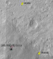
I think this is the area referred to in the GSA paper, a few hundred meters north of the landing site:
Here's the location in relation to the landing site and Glenelg:
Never too soon for reasoned guesses... -------------------- |
||
|
|
|
||
|
Oct 20 2012, 06:42 PM
Post
#270
|
|
 Member Group: Members Posts: 399 Joined: 28-August 07 From: San Francisco Member No.: 3511 |
Glenelg destination too ? We can take a close look, can't wait...
-------------------- 'She drove until the wheels fell off...'
|
|
|
|
|

|
Lo-Fi Version | Time is now: 29th April 2024 - 05:45 PM |
|
RULES AND GUIDELINES Please read the Forum Rules and Guidelines before posting. IMAGE COPYRIGHT |
OPINIONS AND MODERATION Opinions expressed on UnmannedSpaceflight.com are those of the individual posters and do not necessarily reflect the opinions of UnmannedSpaceflight.com or The Planetary Society. The all-volunteer UnmannedSpaceflight.com moderation team is wholly independent of The Planetary Society. The Planetary Society has no influence over decisions made by the UnmannedSpaceflight.com moderators. |
SUPPORT THE FORUM Unmannedspaceflight.com is funded by the Planetary Society. Please consider supporting our work and many other projects by donating to the Society or becoming a member. |
|