Matijevic Hill first survey, Sol 3057 - 3152 |

  |
Matijevic Hill first survey, Sol 3057 - 3152 |
 Nov 3 2012, 08:47 PM Nov 3 2012, 08:47 PM
Post
#451
|
||
 Member  Group: Members Posts: 154 Joined: 19-September 12 Member No.: 6658 |
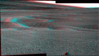
I hope it is ok to post a second one ...
Part of Falconbridge Pancam, Sol 3119:
Is the white stuff there just sand? |
|
 |
 
|
|
|
Nov 3 2012, 10:06 PM
Post
#452
|
|
|
Merciless Robot Group: Admin Posts: 8784 Joined: 8-December 05 From: Los Angeles Member No.: 602 |
QUOTE (ronald @ Nov 3 2012, 12:47 PM)  Is the white stuff there just sand? Yep. Great work!!! 
-------------------- A few will take this knowledge and use this power of a dream realized as a force for change, an impetus for further discovery to make less ancient dreams real.
|
|
|
|
|
Nov 4 2012, 05:39 AM
Post
#453
|
||
 Member Group: Members Posts: 404 Joined: 5-January 10 Member No.: 5161 |
From Sol 3119:
|
|
|
|
|
|
|
Nov 4 2012, 03:43 PM
Post
#454
|
|
 Senior Member Group: Members Posts: 1619 Joined: 12-February 06 From: Bergerac - FR Member No.: 678 |
Sol 3119 Navcam pan :
 And Sol 3121 : 
-------------------- |
|
|
|
|
Nov 4 2012, 04:37 PM
Post
#455
|
||
|
Solar System Cartographer Group: Members Posts: 10166 Joined: 5-April 05 From: Canada Member No.: 227 |
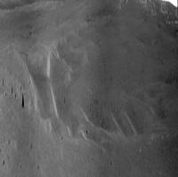
Here is Ant103's 3121 half pan in circular format - another drive to the south. We are approaching the big ancient crater.
Phil
-------------------- ... because the Solar System ain't gonna map itself.
Also to be found posting similar content on https://mastodon.social/@PhilStooke Maps for download (free PD: https://upload.wikimedia.org/wikipedia/comm...Cartography.pdf NOTE: everything created by me which I post on UMSF is considered to be in the public domain (NOT CC, public domain) |
|
|
|
|
|
|
Nov 4 2012, 04:48 PM
Post
#456
|
||
|
Solar System Cartographer Group: Members Posts: 10166 Joined: 5-April 05 From: Canada Member No.: 227 |
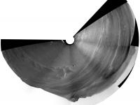
This is a vertically stretched view of the crater ahead - viewed from the north so not in route map geometry.
Phil
-------------------- ... because the Solar System ain't gonna map itself.
Also to be found posting similar content on https://mastodon.social/@PhilStooke Maps for download (free PD: https://upload.wikimedia.org/wikipedia/comm...Cartography.pdf NOTE: everything created by me which I post on UMSF is considered to be in the public domain (NOT CC, public domain) |
|
|
|
|
|
|
Nov 4 2012, 09:49 PM
Post
#457
|
|
|
Newbie Group: Members Posts: 14 Joined: 7-August 12 From: California Member No.: 6489 |
[quote name='ronald' date='Nov 3 2012, 01:15 PM' post='194089']
Color variation of Coniston - Pancam, Sol 3119: I am fairly new to these forums. Many of you are producing beautiful approximations of Mars "true" color from the MER filter 2, 5, 7 filters. Could you describe the process you are using or point me back to discussion of this topic? I have searched without success. ADMIN: Give these pages a try: http://www.unmannedspaceflight.com/index.php?showtopic=761 http://www.unmannedspaceflight.com/index.php?showtopic=529 Use the Forum search tool and use a term like "Filters" |
|
|
|
|
Nov 5 2012, 12:54 AM
Post
#458
|
||
|
Solar System Cartographer Group: Members Posts: 10166 Joined: 5-April 05 From: Canada Member No.: 227 |
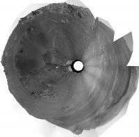
Ant's 3119 pan in circular form.
Phil
-------------------- ... because the Solar System ain't gonna map itself.
Also to be found posting similar content on https://mastodon.social/@PhilStooke Maps for download (free PD: https://upload.wikimedia.org/wikipedia/comm...Cartography.pdf NOTE: everything created by me which I post on UMSF is considered to be in the public domain (NOT CC, public domain) |
|
|
|
|
|
|
Nov 5 2012, 07:44 AM
Post
#459
|
|||
|
Member Group: Members Posts: 404 Joined: 5-January 10 Member No.: 5161 |
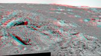
Beautiful undulations on that filled-in crater ahead:
And an anaglyph teased out of images from Sol 3054 and from around Sol 3114, a baseline shift of around 80 meters. It's a little headache-inducing at the nearest mountain, I'm guessing due to the difference in elevation between the two images.
|
||
|
|
|
||
|
Nov 5 2012, 02:39 PM
Post
#460
|
|
|
Member Group: Members Posts: 252 Joined: 5-May 05 From: Mississippi (USA) Member No.: 379 |
QUOTE (walfy @ Nov 5 2012, 03:44 AM) It's a little headache-inducing at the nearest mountain, I believe that your nearest mountain happens to be a future destination of Opportunity. Perhaps the headaches are caused by staring at a 3d view with too much intensity. I actually pasted your anaglyph into IrfanView and expanded it. The details got fuzzy, but the shape of the mountain became clearer to me. Thank-you very much. |
|
|
|
|
Nov 5 2012, 08:52 PM
Post
#461
|
|||
|
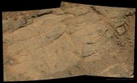
Member Group: Members Posts: 154 Joined: 19-September 12 Member No.: 6658 |
While still waiting for all Falconbridge files I did a quick try on Gertrude - Sol 3117:
|
||
|
|
|
||
|
Nov 5 2012, 11:13 PM
Post
#462
|
|
|
Senior Member Group: Members Posts: 1619 Joined: 12-February 06 From: Bergerac - FR Member No.: 678 |
Nice colors Ronald
Sol 3121 Navcam pan updated (see my previous post). -------------------- |
|
|
|
|
Nov 6 2012, 10:17 AM
Post
#463
|
||
|
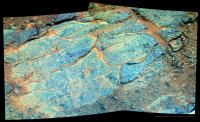
Member Group: Members Posts: 154 Joined: 19-September 12 Member No.: 6658 |
Thank you Ant
- Sao Pantaleao on Sol 3121:
Big version here. Sorry no false color this time but a nice corresponding anaglyph of the far left rock formation. |
|
|
|
|
|
|
Nov 6 2012, 02:35 PM
Post
#464
|
|||
|
Newbie Group: Members Posts: 9 Joined: 27-February 12 Member No.: 6346 |
QUOTE (ronald @ Nov 5 2012, 09:52 PM) While still waiting for all Falconbridge files I did a quick try on Gertrude - Sol 3117:
Any idea what process can cause the ring-like crack in the lower left half the rock? |
||
|
|
|
||
|
Nov 7 2012, 01:26 AM
Post
#465
|
|
|
Senior Member Group: Members Posts: 1044 Joined: 17-February 09 Member No.: 4605 |
QUOTE (CosmicRocker @ Oct 29 2012, 06:38 AM) This is quite a fascinating area. Has anyone deciphered the stratigraphy yet?  Im really starting to doubt that any coherent stratigraphy can be teased out of Cape York. Using Meloshs impact crater morphometric parameters as a guideline the Endeavour rim would have been some 800 metres above the surrounding terrain. This has eroded down to a nub. Potentially all ejecta deposited in the Endeavour impact may have been removed and the Noachian core of Cape York could be upturned or overturned, pre impact terrain. This would have mainly been Miyamoto ejecta in the first place and interpreting this area with Opportunity's limited assets may well be impossible. |
|
|
|
|

|
Lo-Fi Version | Time is now: 23rd May 2024 - 01:44 AM |
|
RULES AND GUIDELINES Please read the Forum Rules and Guidelines before posting. IMAGE COPYRIGHT |
OPINIONS AND MODERATION Opinions expressed on UnmannedSpaceflight.com are those of the individual posters and do not necessarily reflect the opinions of UnmannedSpaceflight.com or The Planetary Society. The all-volunteer UnmannedSpaceflight.com moderation team is wholly independent of The Planetary Society. The Planetary Society has no influence over decisions made by the UnmannedSpaceflight.com moderators. |
SUPPORT THE FORUM Unmannedspaceflight.com is funded by the Planetary Society. Please consider supporting our work and many other projects by donating to the Society or becoming a member. |
|