MSL Route Map |

  |
MSL Route Map |
 Dec 18 2012, 07:27 PM Dec 18 2012, 07:27 PM
Post
#106
|
||
|
Solar System Cartographer  Group: Members Posts: 10153 Joined: 5-April 05 From: Canada Member No.: 227 |
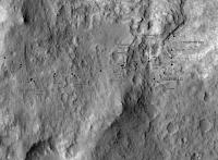
A small update - we moved up to the rock ledge. No names yet in this area.
Phil
-------------------- ... because the Solar System ain't gonna map itself.
Also to be found posting similar content on https://mastodon.social/@PhilStooke Maps for download (free PD: https://upload.wikimedia.org/wikipedia/comm...Cartography.pdf NOTE: everything created by me which I post on UMSF is considered to be in the public domain (NOT CC, public domain) |
|
 |
 
|
|
|
Dec 21 2012, 12:32 PM
Post
#107
|
|
 Senior Member Group: Members Posts: 1465 Joined: 9-February 04 From: Columbus OH USA Member No.: 13 |
The SPICE data files give the elevation of the rover as well. I was thinking about some kind of odometry page--here's a start:
Curiosity drive distance vs. elevation So while the ultimate goal is southwest and up, Curiosity has been steadily heading east and down, now about 18 meters lower than the landing site. But given that Hottah was determined to be an ancient riverbed, and that guano flows downhill, maybe Yellowknife Bay isn't a bad place to be. -------------------- |
|
|
|
|
Dec 21 2012, 10:12 PM
Post
#108
|
|
 Member Group: Members Posts: 754 Joined: 9-February 07 Member No.: 1700 |
Thanks for that chart jmknapp! I've been curious to see a similar chart for Opportunity. Emily did a great elevation overlay for the Google Mars map, but at the time they only had a few passes on the western edge of Endeavour crater. I gotta check that out!
|
|
|
|
|
Dec 23 2012, 03:12 AM
Post
#109
|
||
|
Senior Member Group: Members Posts: 1465 Joined: 9-February 04 From: Columbus OH USA Member No.: 13 |
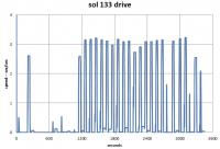
Coming up with drive stats, like the number of drives, for how much distance, what speed, etc. turns out to be tricky! Seems that the rover goes in short bursts, at least according to the SPICE data. Here's a speed vs. time plot of the last drive of about 21 meters on sol 133:
So it took about an hour, with a number of bursts of speed of about 3 cm/sec. Whew! Each sprint is about 1 meter. -------------------- |
|
|
|
|
|
|
Dec 23 2012, 03:30 AM
Post
#110
|
|
|
Solar System Cartographer Group: Members Posts: 10153 Joined: 5-April 05 From: Canada Member No.: 227 |
Hold on to your hat! I really like what you're doing with all this data. Maybe there's a hazard check after each short move?
Phil -------------------- ... because the Solar System ain't gonna map itself.
Also to be found posting similar content on https://mastodon.social/@PhilStooke Maps for download (free PD: https://upload.wikimedia.org/wikipedia/comm...Cartography.pdf NOTE: everything created by me which I post on UMSF is considered to be in the public domain (NOT CC, public domain) |
|
|
|
|
Dec 23 2012, 07:37 PM
Post
#111
|
|
|
Senior Member Group: Members Posts: 1465 Joined: 9-February 04 From: Columbus OH USA Member No.: 13 |
Maybe its nickname could be Chitty Chitty Bang Bang--it just hasn't deployed the wings and propeller yet.
-------------------- |
|
|
|
|
Dec 23 2012, 08:15 PM
Post
#112
|
|
|
Senior Member Group: Moderator Posts: 4279 Joined: 19-April 05 From: .br at .es Member No.: 253 |
QUOTE (Phil Stooke @ Dec 23 2012, 04:30 AM)  Maybe there's a hazard check after each short move? Seems the same as with the MERs when driving with "visodom". |
|
|
|
|
Dec 24 2012, 06:30 AM
Post
#113
|
|
|
Member Group: Admin Posts: 976 Joined: 29-September 06 From: Pasadena, CA - USA Member No.: 1200 |
QUOTE (Tesheiner @ Dec 23 2012, 12:15 PM) Seems the same as with the MERs when driving with "visodom". This drive, as most of the recent drives were done with VisOdom. The 133 drive also had a NavMap checkout during teh first two 1m steps. Paolo -------------------- Disclaimer: all opinions, ideas and information included here are my own,and should not be intended to represent opinion or policy of my employer.
|
|
|
|
|
Dec 27 2012, 02:20 PM
Post
#114
|
|
|
Senior Member Group: Members Posts: 1465 Joined: 9-February 04 From: Columbus OH USA Member No.: 13 |
Here's a page with a log of all the drives to date, based on SPICE files:
Curiosity drive log For each drive there are links for a map and a speed/elevation vs. time plot. Since the rover does a lot of starting and stopping in the midst of drives it's a little arbitrary to define drive boundaries. My code allows stopping intervals of up to 5000 seconds during a drive before it marks it complete. That seems to give a consistent number of drives and confines each one to one sol. That comes out to 34 drives to date--don't know how they officially number the drives, if they do. -------------------- |
|
|
|
|
Dec 27 2012, 05:16 PM
Post
#115
|
|
|
Senior Member Group: Moderator Posts: 4279 Joined: 19-April 05 From: .br at .es Member No.: 253 |
Can't get the links working.
 E.g. "Drive 34 map" shows some data like distance and duration but no map. I'm using IE7 / WinXP on this computer. QUOTE (jmknapp @ Dec 27 2012, 03:20 PM) That comes out to 34 drives to date--don't know how they officially number the drives, if they do. They seem to be using a similar approach as with Spirit / Opportunity, keeping two counters named "site" and "drive". On MER they can be seen on each image filename but on MSL is a bit more complicated. At least we can find them on the navcams e.g. on this one (NLA_409829640EDR_M0051858NCAM00505M_) taken on sol 139, site/drive is 005/1858. |
|
|
|
|
Dec 27 2012, 06:16 PM
Post
#116
|
|
|
Senior Member Group: Members Posts: 1465 Joined: 9-February 04 From: Columbus OH USA Member No.: 13 |
QUOTE (Tesheiner @ Dec 27 2012, 12:16 PM) Can't get the links working. E.g. "Drive 34 map" shows some data like distance and duration but no map. I'm using IE7 / WinXP on this computer. Try setting "compatibility" mode in IE--I think I can do that in the markup but am away from my computer at the moment (sent from my mobile). I wonder what the drive counter signifies--doesn't appear to be meters. EDIT: made a change that appears to have fixed the IE problem. -------------------- |
|
|
|
|
Dec 28 2012, 07:01 PM
Post
#117
|
|
|
Senior Member Group: Moderator Posts: 4279 Joined: 19-April 05 From: .br at .es Member No.: 253 |
QUOTE (jmknapp @ Dec 27 2012, 07:16 PM) I wonder what the drive counter signifies--doesn't appear to be meters. No it's not related to distance but to the number of drive commands within a driving sequence. At least on MER. |
|
|
|
|
Dec 28 2012, 07:05 PM
Post
#118
|
|
|
Solar System Cartographer Group: Members Posts: 10153 Joined: 5-April 05 From: Canada Member No.: 227 |
Just a quick reminder - I'm travelling and will update my map early January when back in my office. The things jmknapp is doing for us are amazing and very welcome.
Phil -------------------- ... because the Solar System ain't gonna map itself.
Also to be found posting similar content on https://mastodon.social/@PhilStooke Maps for download (free PD: https://upload.wikimedia.org/wikipedia/comm...Cartography.pdf NOTE: everything created by me which I post on UMSF is considered to be in the public domain (NOT CC, public domain) |
|
|
|
|
Dec 28 2012, 10:59 PM
Post
#119
|
|
|
Member Group: Admin Posts: 976 Joined: 29-September 06 From: Pasadena, CA - USA Member No.: 1200 |
QUOTE (Tesheiner @ Dec 28 2012, 11:01 AM) No it's not related to distance but to the number of drive commands within a driving sequence. At least on MER. It is the same on MSL as well. It is used to identify a specific location within a drive, and by extension, within a site. Paolo -------------------- Disclaimer: all opinions, ideas and information included here are my own,and should not be intended to represent opinion or policy of my employer.
|
|
|
|
|
Jan 3 2013, 05:05 PM
Post
#120
|
|
|
Senior Member Group: Members Posts: 1465 Joined: 9-February 04 From: Columbus OH USA Member No.: 13 |
Here's a way to get notified by twitter when Curiosity logs a drive:
https://twitter.com/CuriosityLog Follow that to get a tweet when the NAIF position data is updated. The stream currently has the 34 drives to date added in one shot (the most recent drive was on Dec. 20), but future drives should have a more contemporaneous twitter time stamp. My code checks the NAIF files every hour, so there should be no more than a hour between the update and the tweet. Be among the first to know! 
-------------------- |
|
|
|
|

|
Lo-Fi Version | Time is now: 26th April 2024 - 11:51 PM |
|
RULES AND GUIDELINES Please read the Forum Rules and Guidelines before posting. IMAGE COPYRIGHT |
OPINIONS AND MODERATION Opinions expressed on UnmannedSpaceflight.com are those of the individual posters and do not necessarily reflect the opinions of UnmannedSpaceflight.com or The Planetary Society. The all-volunteer UnmannedSpaceflight.com moderation team is wholly independent of The Planetary Society. The Planetary Society has no influence over decisions made by the UnmannedSpaceflight.com moderators. |
SUPPORT THE FORUM Unmannedspaceflight.com is funded by the Planetary Society. Please consider supporting our work and many other projects by donating to the Society or becoming a member. |
|