First drill stop: John Klein in Yellowknife Bay, Site 6, Sol 166-271, January 23-May 12, 2013 |

  |
First drill stop: John Klein in Yellowknife Bay, Site 6, Sol 166-271, January 23-May 12, 2013 |
 Jan 29 2013, 07:17 PM Jan 29 2013, 07:17 PM
Post
#46
|
|
|
Solar System Cartographer  Group: Members Posts: 10153 Joined: 5-April 05 From: Canada Member No.: 227 |
The site counter tells you what coordinate system is being used to locate the rover and targets. Back at the landing site the first images could be used to make a base map showing where everything is, so the cameras, ChemCam etc. can be pointed to specific locations. After the rover drove a short distance on sol 16, and again on sol 21, the same coordinate system still works for new observation planning. But eventually you get too far away and you have to set up a new coordinate system. That's a new site. The counter gets incremented as each new one is established.
Spirit and Opportunity have had hundreds of sites between them. Eventually Curiosity will have lots as well. Phil -------------------- ... because the Solar System ain't gonna map itself.
Also to be found posting similar content on https://mastodon.social/@PhilStooke Maps for download (free PD: https://upload.wikimedia.org/wikipedia/comm...Cartography.pdf NOTE: everything created by me which I post on UMSF is considered to be in the public domain (NOT CC, public domain) |
 |
 
|
|
Jan 29 2013, 07:22 PM
Post
#47
|
|
 Senior Member Group: Moderator Posts: 3431 Joined: 11-August 04 From: USA Member No.: 98 |
QUOTE (centsworth_II @ Jan 29 2013, 01:02 PM)  Could you explain the purpose of the site counter and what incrementing it means? Funny you should mention it, looks like it's explained here (see the last three paragraphs or so). This isn't something new to MSL, by the way; the same system is used on MER, and (Oops, didn't see Phil's earlier post.) |
|
|
|
|
Jan 29 2013, 08:02 PM
Post
#48
|
|
 Senior Member Group: Members Posts: 2173 Joined: 28-December 04 From: Florida, USA Member No.: 132 |
QUOTE (mhoward @ Jan 29 2013, 02:22 PM) Funny you should mention it.... Oy! Thanks to you and Phil for the explanations and thanks for the link. That's what happens when one fails to keep up with Emily's blog! An unusual lapse on my part. |
|
|
|
|
Jan 29 2013, 10:47 PM
Post
#49
|
|
|
Member Group: Admin Posts: 976 Joined: 29-September 06 From: Pasadena, CA - USA Member No.: 1200 |
QUOTE (centsworth_II @ Jan 29 2013, 11:02 AM) Normally I don' t bother with the tech talk that goes over my head, but this one is bothering me. Could you explain the purpose of the site counter and what incrementing it means? It is a convenience. After you drive for a while, the rover coordinates, and the coordinates of various targets, start to have many significant digits and it is easy to make mistakes when manually checking large numbers. Therefore, we periodically reset the origin of the coordinate system and we refer the new X, and Y coordinates to the new "site index" to avoid confusing the same coordinates but relative to a different origin. These coordinate systems are always parallel to each other, that is, X is always pointed to North and Y is always pointed to East but the location of coordinate 0, 0 changes at each site index. Paolo -------------------- Disclaimer: all opinions, ideas and information included here are my own,and should not be intended to represent opinion or policy of my employer.
|
|
|
|
|
Jan 29 2013, 11:52 PM
Post
#50
|
|
 Administrator Group: Admin Posts: 5172 Joined: 4-August 05 From: Pasadena, CA, USA, Earth Member No.: 454 |
ChemCam views of the drill bit coming down now! Neato.
This one begs the question, which one is scarier to have pointed at you -- a percussive drill or a laser beam? -------------------- My website - My Patreon - @elakdawalla on Twitter - Please support unmannedspaceflight.com by donating here.
|
|
|
|
|
Jan 30 2013, 12:11 AM
Post
#51
|
|
 Senior Member Group: Admin Posts: 3108 Joined: 21-December 05 From: Canberra, Australia Member No.: 615 |
 I'll take MSL's laser over the drill anyday. Mainly for the less blood and gore factor I'll take MSL's laser over the drill anyday. Mainly for the less blood and gore factor
|
|
|
|
|
Jan 30 2013, 12:24 AM
Post
#52
|
|
|
Solar System Cartographer Group: Members Posts: 10153 Joined: 5-April 05 From: Canada Member No.: 227 |
This just in - the rock which was brushed a few sols ago is called Wernecke (from the 'where is Curiosity' part of the MSL website).
It's really bugging me that i can't find that last drill contact location. Anyone else see it? Phil -------------------- ... because the Solar System ain't gonna map itself.
Also to be found posting similar content on https://mastodon.social/@PhilStooke Maps for download (free PD: https://upload.wikimedia.org/wikipedia/comm...Cartography.pdf NOTE: everything created by me which I post on UMSF is considered to be in the public domain (NOT CC, public domain) |
|
|
|
|
Jan 30 2013, 01:01 AM
Post
#53
|
|
 Member Group: Members Posts: 161 Joined: 12-August 12 From: Hillsborough, NJ Member No.: 6546 |
Here's an animated GIF of the drill bit (ChemCam - Sol 172).
 http://makeagif.com/media/1-29-2013/OzNl2F.gif -------------------- |
|
|
|
|
Jan 30 2013, 02:52 AM
Post
#54
|
|||
 Member Group: Members Posts: 408 Joined: 3-August 05 Member No.: 453 |
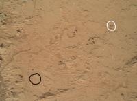
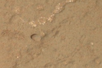
I think I found the missing contact point (circled in white); looks like the post rested on a small pebble which then moved just a little bit - it is more than just the shadow moving. I used lines on each image to verify that is was indeed the pebble that moved, and the
Blink animation, scaled 200%:
Airbag |
||
|
|
|
||
|
Jan 30 2013, 02:57 AM
Post
#55
|
|
|
Solar System Cartographer Group: Members Posts: 10153 Joined: 5-April 05 From: Canada Member No.: 227 |
I think you're right!
Phil -------------------- ... because the Solar System ain't gonna map itself.
Also to be found posting similar content on https://mastodon.social/@PhilStooke Maps for download (free PD: https://upload.wikimedia.org/wikipedia/comm...Cartography.pdf NOTE: everything created by me which I post on UMSF is considered to be in the public domain (NOT CC, public domain) |
|
|
|
|
Jan 30 2013, 04:58 AM
Post
#56
|
|
|
Newbie Group: Members Posts: 3 Joined: 9-October 12 Member No.: 6693 |
QUOTE (iMPREPREX @ Jan 29 2013, 05:01 PM) Here's an animated GIF of the drill bit (ChemCam - Sol 172). http://makeagif.com/media/1-29-2013/OzNl2F.gif Forgive me as I'm a noob. But I do know rock "Hiliti" type drills (only in Concrete and Granite type rock). This looks like the fouling they were worried about. EDIT: I realize now that the angle makes the flukes look fouled. But that is not the case. |
|
|
|
|
Jan 30 2013, 05:35 PM
Post
#57
|
|
 Member Group: Members Posts: 222 Joined: 7-August 12 From: Garberville, CA Member No.: 6500 |
Here's a preliminary look at the very nice (and huge!) Sol 170 MC34 panorama. Interestingly, it seems the big 15 frame block that's missing at upper right seems to have been purposefully skipped, as the row sequence numbers do not show any numeric break across the 3 rows of the gap. This faces the low sun angle, so not sure if that was a consideration or not. The other two missing frames at right have thumbs down so presumably will be in soon, and there are two more missing frames that appear to extend the far upper right of the pan. There's a small stitching anomaly at the left flank and base of Mt.Sharp I'll try and fix in the final version. There's a ton of detail in here of areas not previously covered by the MC's on the flat of bay.
Click thumb for half resolution version (15000 x 4285 px - 9.24MB):  The original came in at just over 32,000 pixels so I reduced it to 30,000 for now to save the JPG easily after PS post-processing. Will render a full sized version when the missing frames are in. For now, the near full resolution version (30000 x 8569 px - 26.72MB - ZIP File) is here: Sol170-MC34-Mt.Sharp-Yellowknife-Panorama-30000x8569px.zip -------------------- "We shall not cease from exploration, and the end of all our exploring will be to arrive where we started and know the place for the first time." -T.S. Eliot
|
|
|
|
|
Jan 30 2013, 05:50 PM
Post
#58
|
|
|
Senior Member Group: Members Posts: 2511 Joined: 13-September 05 Member No.: 497 |
QUOTE (EdTruthan @ Jan 30 2013, 10:35 AM) Interestingly, it seems the big 15 frame block that's missing at upper right seems to have been purposefully skipped... The big block at the lower left also appears to have been purposefully skipped  Seriously, I don't know why they would skip a big area like that; perhaps it was covered by some earlier sequence or that's the divide between multiple sequences which will be filled in shortly? -------------------- Disclaimer: This post is based on public information only. Any opinions are my own.
|
|
|
|
|
Jan 30 2013, 07:31 PM
Post
#59
|
|
|
Administrator Group: Admin Posts: 5172 Joined: 4-August 05 From: Pasadena, CA, USA, Earth Member No.: 454 |
This is a seriously scenic spot; it would be absolutely crazy not to fill in that "missing block at lower left"!! There's gotta be something we can do to make some noise about that.
-------------------- My website - My Patreon - @elakdawalla on Twitter - Please support unmannedspaceflight.com by donating here.
|
|
|
|
|
Jan 30 2013, 07:37 PM
Post
#60
|
|
|
Solar System Cartographer Group: Members Posts: 10153 Joined: 5-April 05 From: Canada Member No.: 227 |
Patience! We'll be here for weeks.
Phil -------------------- ... because the Solar System ain't gonna map itself.
Also to be found posting similar content on https://mastodon.social/@PhilStooke Maps for download (free PD: https://upload.wikimedia.org/wikipedia/comm...Cartography.pdf NOTE: everything created by me which I post on UMSF is considered to be in the public domain (NOT CC, public domain) |
|
|
|
|

|
Lo-Fi Version | Time is now: 27th April 2024 - 02:59 PM |
|
RULES AND GUIDELINES Please read the Forum Rules and Guidelines before posting. IMAGE COPYRIGHT |
OPINIONS AND MODERATION Opinions expressed on UnmannedSpaceflight.com are those of the individual posters and do not necessarily reflect the opinions of UnmannedSpaceflight.com or The Planetary Society. The all-volunteer UnmannedSpaceflight.com moderation team is wholly independent of The Planetary Society. The Planetary Society has no influence over decisions made by the UnmannedSpaceflight.com moderators. |
SUPPORT THE FORUM Unmannedspaceflight.com is funded by the Planetary Society. Please consider supporting our work and many other projects by donating to the Society or becoming a member. |
|